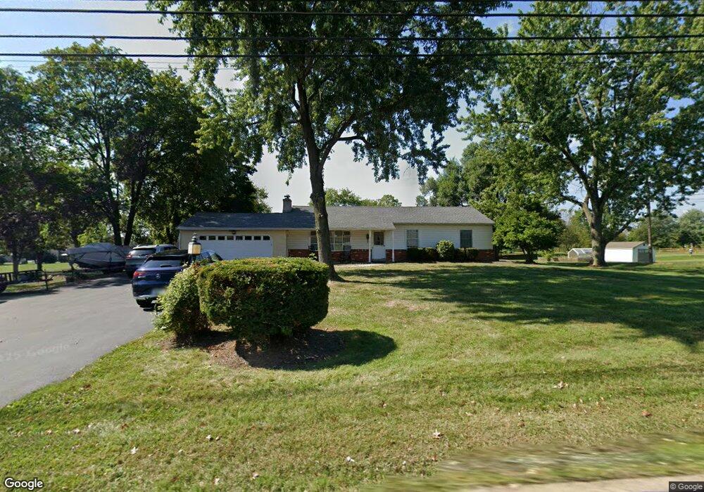
372 Moyer Rd Souderton, PA 18964
Estimated Value: $472,000 - $506,000
3
Beds
2
Baths
1,548
Sq Ft
$316/Sq Ft
Est. Value
About This Home
This home is located at 372 Moyer Rd, Souderton, PA 18964 and is currently estimated at $488,799, approximately $315 per square foot. 372 Moyer Rd is a home located in Montgomery County with nearby schools including West Broad Street Elementary School, Indian Crest Middle School, and Souderton Area Senior High School.
Ownership History
Date
Name
Owned For
Owner Type
Purchase Details
Closed on
Feb 23, 2004
Sold by
Derstine Robert B and Derstine Catherine A
Bought by
Derstine Robert B and Derstine Catherine A
Current Estimated Value
Home Financials for this Owner
Home Financials are based on the most recent Mortgage that was taken out on this home.
Original Mortgage
$165,000
Outstanding Balance
$76,254
Interest Rate
5.62%
Estimated Equity
$412,545
Purchase Details
Closed on
Nov 1, 1996
Sold by
Cherry Wayne G and Cherry Joan L
Bought by
Derstine Robert B
Create a Home Valuation Report for This Property
The Home Valuation Report is an in-depth analysis detailing your home's value as well as a comparison with similar homes in the area
Home Values in the Area
Average Home Value in this Area
Purchase History
| Date | Buyer | Sale Price | Title Company |
|---|---|---|---|
| Derstine Robert B | -- | -- | |
| Derstine Robert B | $125,000 | -- |
Source: Public Records
Mortgage History
| Date | Status | Borrower | Loan Amount |
|---|---|---|---|
| Open | Derstine Robert B | $165,000 |
Source: Public Records
Tax History Compared to Growth
Tax History
| Year | Tax Paid | Tax Assessment Tax Assessment Total Assessment is a certain percentage of the fair market value that is determined by local assessors to be the total taxable value of land and additions on the property. | Land | Improvement |
|---|---|---|---|---|
| 2025 | $5,923 | $147,480 | $55,180 | $92,300 |
| 2024 | $5,923 | $147,480 | $55,180 | $92,300 |
| 2023 | $5,652 | $147,480 | $55,180 | $92,300 |
| 2022 | $5,479 | $147,480 | $55,180 | $92,300 |
| 2021 | $5,364 | $147,480 | $55,180 | $92,300 |
| 2020 | $5,291 | $147,480 | $55,180 | $92,300 |
| 2019 | $4,830 | $147,480 | $55,180 | $92,300 |
| 2018 | $5,228 | $147,480 | $55,180 | $92,300 |
| 2017 | $5,096 | $147,480 | $55,180 | $92,300 |
| 2016 | $5,039 | $147,480 | $55,180 | $92,300 |
| 2015 | $4,902 | $147,480 | $55,180 | $92,300 |
| 2014 | $4,902 | $147,480 | $55,180 | $92,300 |
Source: Public Records
Map
Nearby Homes
- 0000 Halteman Rd
- 264 Wilton Ct
- 244 Sumner Ct
- 624 Keller Creamery Rd
- 137 Bridle View Way
- 635 Elroy Rd
- 552 Creekside Dr
- 654 Allentown Rd
- 478 Smokepipe Rd
- 723 Finlay Dr
- 265 Maple Ave
- Westchester Plan at Reserve at Franconia
- Ashton Plan at Reserve at Franconia - Townhomes Series
- 110 Trevor Square
- 292 Florence Dr
- 624 Crestwood Dr
- 531-537-545 Main St
- 62 Oxford Terrace
- 317 Pleasant Valley Dr
- 3443 Devlin Way