Estimated Value: $258,000 - $395,126
Studio
--
Bath
--
Sq Ft
10,890
Sq Ft Lot
About This Home
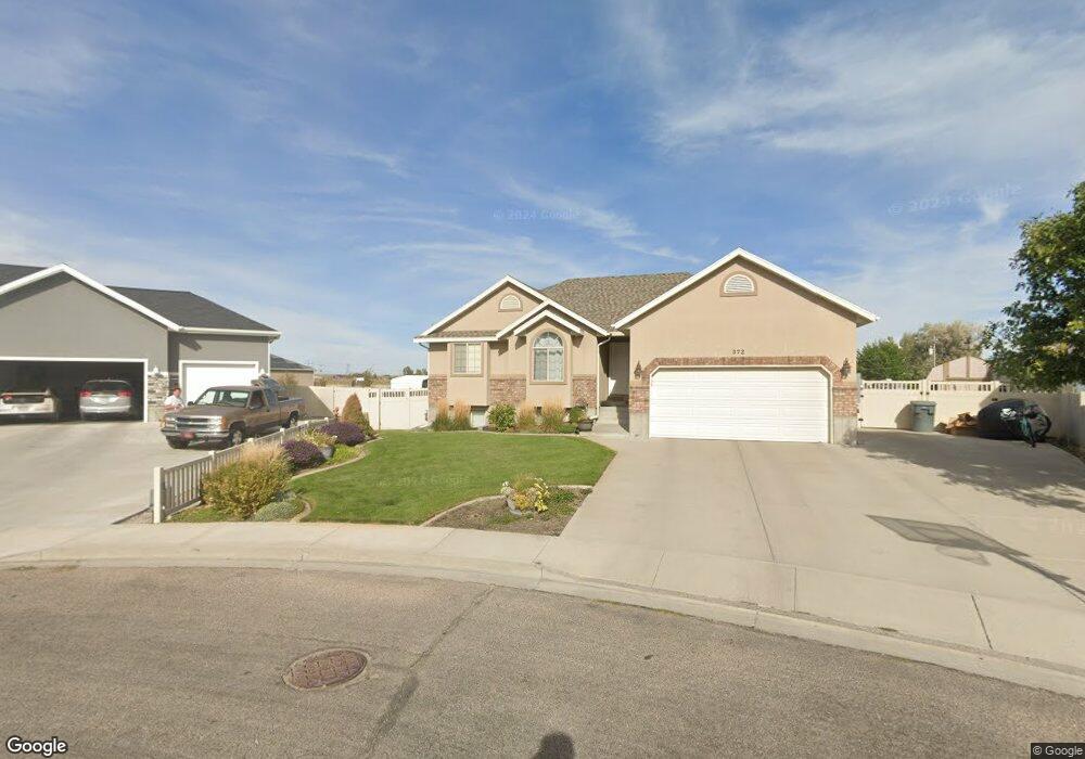
This home is located at 372 N 525 E, Delta, UT 84624 and is currently estimated at $343,709. 372 N 525 E is a home with nearby schools including Cba Center and White River Academy.
Ownership History
Date
Name
Owned For
Owner Type
Purchase Details
Closed on
Feb 14, 2006
Sold by
Sr Pratt Construction & Home Repair I
Bought by
Allred Brain Wade and Allred Tiffany Monique
Current Estimated Value
Home Financials for this Owner
Home Financials are based on the most recent Mortgage that was taken out on this home.
Original Mortgage
$136,000
Outstanding Balance
$86,723
Interest Rate
6.04%
Estimated Equity
$256,986
Purchase Details
Closed on
Jan 31, 2006
Sold by
Grant S Nielson Family Partnership Ll
Bought by
S R Pratt Construction & Home Repair In
Home Financials for this Owner
Home Financials are based on the most recent Mortgage that was taken out on this home.
Original Mortgage
$136,000
Outstanding Balance
$86,723
Interest Rate
6.04%
Estimated Equity
$256,986
Create a Home Valuation Report for This Property
The Home Valuation Report is an in-depth analysis detailing your home's value as well as a comparison with similar homes in the area
Home Values in the Area
Average Home Value in this Area
Purchase History
| Date | Buyer | Sale Price | Title Company |
|---|---|---|---|
| Allred Brain Wade | -- | -- | |
| S R Pratt Construction & Home Repair In | -- | -- |
Source: Public Records
Mortgage History
| Date | Status | Borrower | Loan Amount |
|---|---|---|---|
| Open | Allred Brain Wade | $136,000 |
Source: Public Records
Tax History
| Year | Tax Paid | Tax Assessment Tax Assessment Total Assessment is a certain percentage of the fair market value that is determined by local assessors to be the total taxable value of land and additions on the property. | Land | Improvement |
|---|---|---|---|---|
| 2025 | $2,515 | $269,077 | $16,546 | $252,531 |
| 2024 | $2,515 | $216,642 | $14,899 | $201,743 |
| 2023 | $2,674 | $216,642 | $14,899 | $201,743 |
| 2022 | $2,051 | $154,364 | $13,544 | $140,820 |
| 2021 | $1,760 | $126,437 | $11,778 | $114,659 |
| 2020 | $1,639 | $117,005 | $10,707 | $106,298 |
| 2019 | $1,372 | $98,040 | $10,395 | $87,645 |
| 2018 | $1,323 | $95,274 | $10,395 | $84,879 |
| 2017 | $1,373 | $95,274 | $10,395 | $84,879 |
| 2016 | $1,331 | $95,274 | $10,395 | $84,879 |
| 2015 | $1,330 | $95,274 | $10,395 | $84,879 |
| 2014 | -- | $82,919 | $10,395 | $72,524 |
| 2013 | -- | $82,919 | $10,395 | $72,524 |
Source: Public Records
Map
Nearby Homes
- 628 Sunset St
- 520 E 450 North Rd
- 7900 E 250 Rd N
- 445 Topaz Blvd Unit 10
- 901 E 750 Rd N
- Locust Ave Unit LotWP001
- 44 E 300 S
- 0 E Highway 6 Unit LotWP001 16586023
- 87 S 300 East Rd
- 321 E 200 S
- 325 N 100 W
- 700 N Highway 6
- 648 Tamarix St
- 38 E 300 S
- 32 E 300 S
- 163 W 100 S
- 98 W 1000 N
- 7430 W 3000 N
- 451 W 300 N
- 341 W 100 S
Your Personal Tour Guide
Ask me questions while you tour the home.