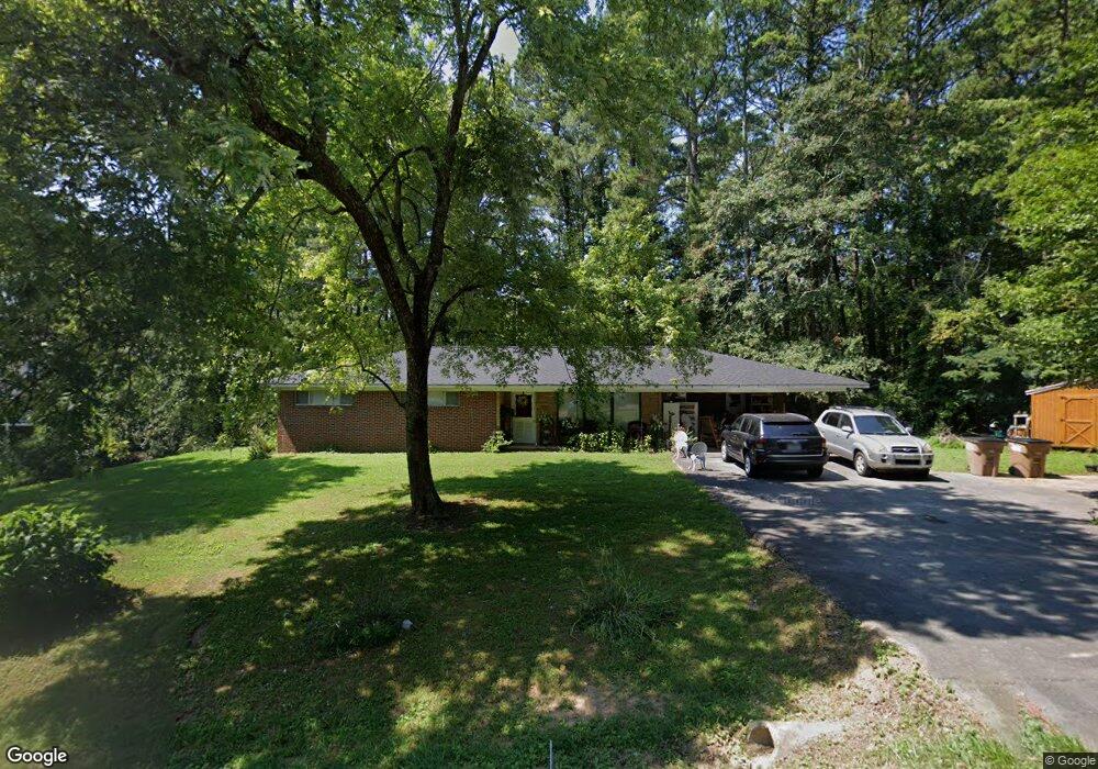
3724 Airport Rd SE Dalton, GA 30721
Estimated Value: $189,000 - $268,000
3
Beds
2
Baths
1,535
Sq Ft
$150/Sq Ft
Est. Value
About This Home
This home is located at 3724 Airport Rd SE, Dalton, GA 30721 and is currently estimated at $230,477, approximately $150 per square foot. 3724 Airport Rd SE is a home located in Whitfield County with nearby schools including Cedar Ridge Elementary School, Eastbrook Middle School, and Southeast Whitfield County High School.
Ownership History
Date
Name
Owned For
Owner Type
Purchase Details
Closed on
Jun 27, 2016
Sold by
Flowers Heather Nicole
Bought by
Rittenhouse Richard David
Current Estimated Value
Purchase Details
Closed on
Jul 18, 2013
Sold by
Souther Gordon Anthony
Bought by
Roberts J Ralph
Purchase Details
Closed on
Jul 28, 2004
Sold by
Souther Miles G
Bought by
Souther Gordon Anthony
Purchase Details
Closed on
Jun 24, 2004
Sold by
Souther Gordon and Souther Eloise
Bought by
Souther Miles G and Souther Gordon A
Purchase Details
Closed on
Jul 28, 2003
Sold by
Souther Gordon and Souther Eloise
Bought by
Souther Gordon Anthony
Purchase Details
Closed on
Sep 1, 1999
Bought by
Souther Gordon and Souther Eloise
Create a Home Valuation Report for This Property
The Home Valuation Report is an in-depth analysis detailing your home's value as well as a comparison with similar homes in the area
Home Values in the Area
Average Home Value in this Area
Purchase History
| Date | Buyer | Sale Price | Title Company |
|---|---|---|---|
| Rittenhouse Richard David | -- | -- | |
| Roberts J Ralph | $50,000 | -- | |
| Souther Gordon Anthony | -- | -- | |
| Souther Miles G | -- | -- | |
| Souther Miles G | -- | -- | |
| Souther Gordon Anthony | -- | -- | |
| Souther Gordon | $2,000 | -- |
Source: Public Records
Tax History Compared to Growth
Tax History
| Year | Tax Paid | Tax Assessment Tax Assessment Total Assessment is a certain percentage of the fair market value that is determined by local assessors to be the total taxable value of land and additions on the property. | Land | Improvement |
|---|---|---|---|---|
| 2024 | $1,734 | $78,487 | $5,656 | $72,831 |
| 2023 | $1,734 | $57,964 | $3,620 | $54,344 |
| 2022 | $1,204 | $40,832 | $3,552 | $37,280 |
| 2021 | $1,205 | $40,832 | $3,552 | $37,280 |
| 2020 | $1,246 | $40,832 | $3,552 | $37,280 |
| 2019 | $1,266 | $40,832 | $3,552 | $37,280 |
| 2018 | $1,264 | $40,104 | $2,824 | $37,280 |
| 2017 | $1,264 | $40,104 | $2,824 | $37,280 |
| 2016 | $1,115 | $36,767 | $2,824 | $33,943 |
| 2014 | $538 | $17,715 | $4,381 | $33,943 |
| 2013 | -- | $38,324 | $4,381 | $33,942 |
Source: Public Records
Map
Nearby Homes
- 3657 Airport Rd
- 01 Headrick Cir SE
- 00 Headrick Cir SE
- 1142 Ben Hill Rd SE
- 296 Wagner Dr
- 1271 Ridge Rd SE
- 760 Keith Rd SE
- 00 Tibbs Bridge Rd
- 2200 Ridge Rd SE
- 4322 Banks Dr SE
- 00 Hill Rd
- 0 Tibbs Bridge Rd SE
- 185 Cedar Ridge Rd
- 1401 Eastbrook Dr SE
- 118 Hill Rd
- TBD Old Grade Rd
- 0 Old Grade Rd
- 136 Wiltshire Dr
- 4386 Tibbs Bridge Rd SE
- 1401 Eastbrook Rd SE
- 140 Della Way
- 3741 Airport Rd SE
- 188 Della Way
- 185 Della Way
- 153 Della Way
- 3698 Airport Rd SE
- 3742 Airport Rd SE
- 1216 Lynn Dr SE
- 1134 Mobley Mill Rd SE
- 3728 Airport Rd SE
- 1221 Lynn Dr SE
- 1132 Mobley Mill Rd SE
- 2016 Ashton Ln SE
- 3703 Airport Rd
- 3749 Airport Rd SE
- 1128 Mobley Mill Rd SE
- 1124 Rodger Dr
- 3699 Airport Rd SE
- 1122 Mobley Mill Rd SE
- 1131 Mobley Mill Rd SE