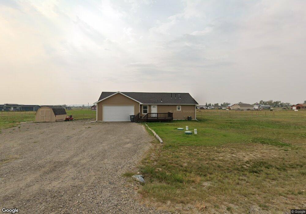
3726 Osness Rd Shepherd, MT 59079
Estimated Value: $336,000 - $385,000
3
Beds
2
Baths
1,316
Sq Ft
$275/Sq Ft
Est. Value
About This Home
This home is located at 3726 Osness Rd, Shepherd, MT 59079 and is currently estimated at $361,311, approximately $274 per square foot. 3726 Osness Rd is a home located in Yellowstone County with nearby schools including Shepherd Elementary School, Shepherd Middle School, and Shepherd High School.
Ownership History
Date
Name
Owned For
Owner Type
Purchase Details
Closed on
Feb 28, 2024
Sold by
Commercial Funding Consultants Llc
Bought by
Brown Scott L and Brown Kaylee H
Current Estimated Value
Home Financials for this Owner
Home Financials are based on the most recent Mortgage that was taken out on this home.
Original Mortgage
$247,000
Outstanding Balance
$158,750
Interest Rate
10%
Mortgage Type
New Conventional
Estimated Equity
$202,561
Purchase Details
Closed on
May 13, 2010
Sold by
F P Inc
Bought by
Lilleberg Philip A and Lilleberg Betty J
Purchase Details
Closed on
Mar 2, 2010
Sold by
F P Inc
Bought by
Lilleberg Philip A and Lilleberg Betty J
Create a Home Valuation Report for This Property
The Home Valuation Report is an in-depth analysis detailing your home's value as well as a comparison with similar homes in the area
Purchase History
| Date | Buyer | Sale Price | Title Company |
|---|---|---|---|
| Brown Scott L | -- | None Listed On Document | |
| Lilleberg Philip A | -- | None Available | |
| Lilleberg Philip A | -- | None Available |
Source: Public Records
Mortgage History
| Date | Status | Borrower | Loan Amount |
|---|---|---|---|
| Open | Brown Scott L | $247,000 |
Source: Public Records
Tax History
| Year | Tax Paid | Tax Assessment Tax Assessment Total Assessment is a certain percentage of the fair market value that is determined by local assessors to be the total taxable value of land and additions on the property. | Land | Improvement |
|---|---|---|---|---|
| 2025 | $2,586 | $311,300 | $35,787 | $275,513 |
| 2024 | $2,586 | $296,200 | $28,192 | $268,008 |
| 2023 | $2,630 | $296,200 | $28,192 | $268,008 |
| 2022 | $1,934 | $205,700 | $0 | $0 |
| 2021 | $2,056 | $205,700 | $0 | $0 |
| 2020 | $2,084 | $202,000 | $0 | $0 |
| 2019 | $1,733 | $202,000 | $0 | $0 |
| 2018 | $1,744 | $191,400 | $0 | $0 |
| 2017 | $1,712 | $191,400 | $0 | $0 |
| 2016 | $1,572 | $182,700 | $0 | $0 |
| 2015 | $1,565 | $201,200 | $0 | $0 |
| 2014 | $1,344 | $84,217 | $0 | $0 |
Source: Public Records
Map
Nearby Homes
- L11B2 Rio Lobo Cir
- L13B2 High Noon Dr
- L12B2 High Noon Dr
- L11B3 High Noon Dr
- L10B3 High Noon Dr
- L8B2 High Noon Dr
- L12B3 Molly Dr
- L13B3 Molly Dr
- L8B3 High Noon Dr
- TBD High Noon Dr
- L3B4 Trumbo Cir
- L6B2 High Noon Dr
- L15B3 True Grit St
- L2B4 True Grit St
- L6B3 High Noon Dr
- 3514 High Noon
- L4B4 Trumbo Cir
- L1B4 True Grit St
- L5B4 Trumbo Cir
- L16B3 True Grit St
- 3708 Osness Rd
- 3810 Osness Rd
- 3803 Pheasant Rd
- 3819 Pheasant Rd
- 6733 High Hill Rd
- 3804 Pheasant Rd
- 3620 Orville Cir
- 3818 Pheasant Rd
- 6732 High Hill Rd
- 3835 Pheasant Rd
- 3680 Orville Cir
- 6710 High Hill Rd
- 6637 High Hill Rd
- 6635 Killdeer Ln
- 3906 Osness Rd
- 3909 Pheasant Rd
- 6731 Steiner Dr
- 6707 Steiner Dr
- 0 Pheasant Rd Unit 344956
- 0 Pheasant Rd
Your Personal Tour Guide
Ask me questions while you tour the home.