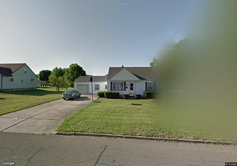
373 Brandon Ave Struthers, OH 44471
Estimated Value: $138,000 - $180,000
3
Beds
2
Baths
1,634
Sq Ft
$99/Sq Ft
Est. Value
About This Home
This home is located at 373 Brandon Ave, Struthers, OH 44471 and is currently estimated at $161,068, approximately $98 per square foot. 373 Brandon Ave is a home located in Mahoning County with nearby schools including Struthers Elementary School, Struthers Middle School, and Struthers High School.
Ownership History
Date
Name
Owned For
Owner Type
Purchase Details
Closed on
Oct 26, 2021
Bought by
Sandra Carson
Current Estimated Value
Purchase Details
Closed on
Jul 28, 1997
Bought by
Mary Ellen Morocco
Purchase Details
Closed on
Jan 19, 1972
Bought by
Mickler John S and Mickler Marion
Create a Home Valuation Report for This Property
The Home Valuation Report is an in-depth analysis detailing your home's value as well as a comparison with similar homes in the area
Home Values in the Area
Average Home Value in this Area
Purchase History
| Date | Buyer | Sale Price | Title Company |
|---|---|---|---|
| Sandra Carson | -- | -- | |
| Mary Ellen Morocco | -- | -- | |
| Mickler John S | -- | -- |
Source: Public Records
Tax History
| Year | Tax Paid | Tax Assessment Tax Assessment Total Assessment is a certain percentage of the fair market value that is determined by local assessors to be the total taxable value of land and additions on the property. | Land | Improvement |
|---|---|---|---|---|
| 2025 | $1,549 | $36,390 | $2,660 | $33,730 |
| 2024 | $1,549 | $36,390 | $2,660 | $33,730 |
| 2023 | $1,490 | $36,390 | $2,660 | $33,730 |
| 2022 | $1,449 | $25,520 | $2,500 | $23,020 |
| 2021 | $1,400 | $25,520 | $2,500 | $23,020 |
| 2020 | $1,406 | $25,520 | $2,500 | $23,020 |
| 2019 | $1,347 | $22,200 | $2,180 | $20,020 |
| 2018 | $1,486 | $22,200 | $2,180 | $20,020 |
| 2017 | $1,386 | $22,200 | $2,180 | $20,020 |
| 2016 | $1,488 | $26,340 | $2,540 | $23,800 |
| 2015 | $1,527 | $26,340 | $2,540 | $23,800 |
| 2014 | $1,459 | $26,340 | $2,540 | $23,800 |
| 2013 | $1,360 | $26,340 | $2,540 | $23,800 |
Source: Public Records
Map
Nearby Homes
- 795 5th St
- 453 W Omar St
- 227 Wilson St
- 587 Edison St
- 1054 Runge Ave
- 250 E Manor Ave
- 611 W Wilson St
- 0 Smithfield St Unit 4336782
- 143 Wilson St
- 457 Sexton St
- 281 Sexton St
- 265 Sexton St
- 306 Maplewood Ave
- 464 Elm St
- 227 Maplewood Ave
- 2089 Shetland Ln
- 59 Harvey St
- 627 Poland Ave
- 2370 Lyon Blvd
- 39 Renee Dr
- 367 Brandon Ave
- 385 Brandon Ave
- 359 Brandon Ave
- 372 Geneva Ave
- 366 Geneva Ave
- 360 Geneva Ave
- 393 Brandon Ave
- 368 Brandon Ave
- 384 Geneva Ave
- 378 Brandon Ave
- 352 Geneva Ave
- 386 Brandon Ave
- 394 Geneva Ave
- 345 Brandon Ave
- 360 Brandon Ave
- 394 Brandon Ave
- 397 Brandon Ave
- 400 Geneva Ave
- 348 Geneva Ave
- 400 Brandon Ave
Your Personal Tour Guide
Ask me questions while you tour the home.