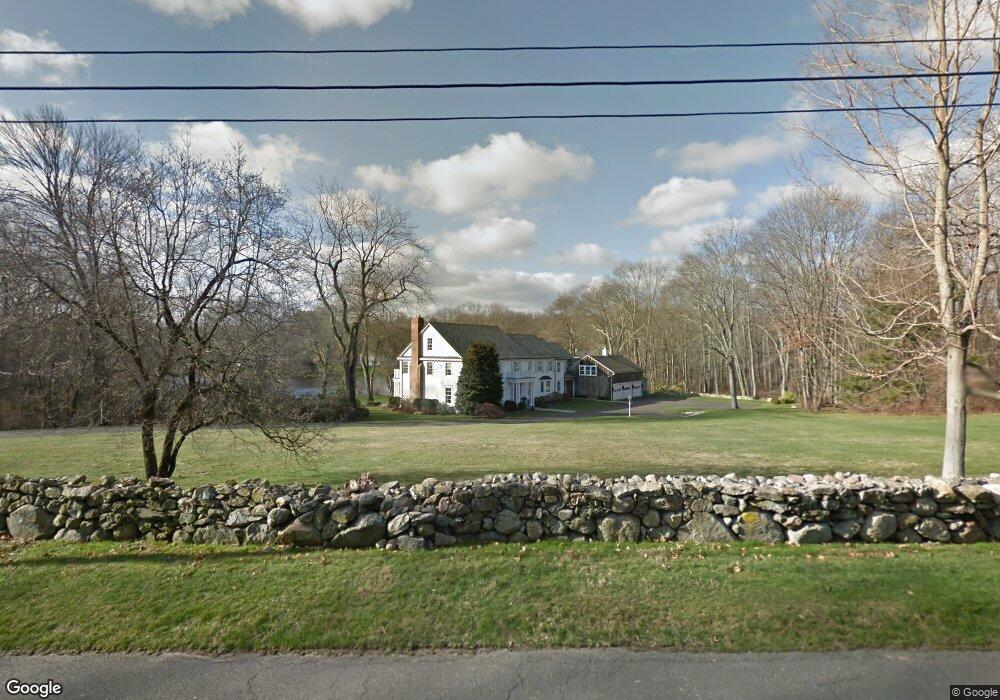
373 Brookside Rd Darien, CT 06820
Estimated Value: $3,975,000 - $6,020,484
5
Beds
6
Baths
5,085
Sq Ft
$993/Sq Ft
Est. Value
About This Home
This home is located at 373 Brookside Rd, Darien, CT 06820 and is currently estimated at $5,051,371, approximately $993 per square foot. 373 Brookside Rd is a home located in Fairfield County with nearby schools including Ox Ridge Elementary School, Middlesex Middle School, and Darien High School.
Ownership History
Date
Name
Owned For
Owner Type
Purchase Details
Closed on
Aug 2, 2021
Sold by
Leonard Robert G and Leonard Jacqueline E
Bought by
Blackwell Tyler and Barth Alexandra
Current Estimated Value
Home Financials for this Owner
Home Financials are based on the most recent Mortgage that was taken out on this home.
Original Mortgage
$2,800,000
Outstanding Balance
$2,549,863
Interest Rate
3%
Mortgage Type
Purchase Money Mortgage
Estimated Equity
$2,501,508
Purchase Details
Closed on
Jun 7, 2004
Sold by
Noyes-Ludemann Audrey
Bought by
Leonard Robert G and Leonard Jacqueline E
Home Financials for this Owner
Home Financials are based on the most recent Mortgage that was taken out on this home.
Original Mortgage
$500,000
Interest Rate
4.25%
Create a Home Valuation Report for This Property
The Home Valuation Report is an in-depth analysis detailing your home's value as well as a comparison with similar homes in the area
Home Values in the Area
Average Home Value in this Area
Purchase History
| Date | Buyer | Sale Price | Title Company |
|---|---|---|---|
| Blackwell Tyler | $4,450,000 | None Available | |
| Leonard Robert G | $4,100,000 | -- |
Source: Public Records
Mortgage History
| Date | Status | Borrower | Loan Amount |
|---|---|---|---|
| Open | Blackwell Tyler | $2,800,000 | |
| Previous Owner | Leonard Robert G | $500,000 | |
| Previous Owner | Leonard Robert G | $500,000 | |
| Previous Owner | Leonard Robert G | $500,000 |
Source: Public Records
Tax History
| Year | Tax Paid | Tax Assessment Tax Assessment Total Assessment is a certain percentage of the fair market value that is determined by local assessors to be the total taxable value of land and additions on the property. | Land | Improvement |
|---|---|---|---|---|
| 2025 | $50,083 | $3,235,330 | $1,495,550 | $1,739,780 |
| 2024 | $42,585 | $2,898,910 | $1,495,550 | $1,403,360 |
| 2023 | $39,031 | $2,216,410 | $1,163,190 | $1,053,220 |
| 2022 | $38,189 | $2,216,410 | $1,163,190 | $1,053,220 |
| 2021 | $37,324 | $2,216,410 | $1,163,190 | $1,053,220 |
| 2020 | $36,260 | $2,216,410 | $1,163,190 | $1,053,220 |
| 2019 | $36,504 | $2,216,410 | $1,163,190 | $1,053,220 |
| 2018 | $40,966 | $2,547,650 | $1,288,280 | $1,259,370 |
| 2017 | $41,170 | $2,547,650 | $1,288,280 | $1,259,370 |
| 2016 | $40,176 | $2,547,650 | $1,288,280 | $1,259,370 |
| 2015 | $39,106 | $2,547,650 | $1,288,280 | $1,259,370 |
| 2014 | $38,240 | $2,547,650 | $1,288,280 | $1,259,370 |
Source: Public Records
Map
Nearby Homes
- 63 Dorchester Rd
- 20 Marianne Rd
- 15 Marianne Rd
- 201 W Norwalk Rd
- 7 Tommys Ln
- 45 Princes Pine Rd
- 58 Old Rock Ln
- 561 Middlesex Rd
- 7 Buttonwood Ln
- 226 Putnam Rd
- 1 Douglas Dr
- 28 Crooked Mile Rd
- 12 Dellwood Rd
- 48 Green Meadow Ln
- 105 White Oak Shade Rd
- 97 Richards Ave Unit B10
- 9 Point o Woods Rd S
- 105 Richards Ave Unit 1407
- 12 Field Crest Rd
- 29 Richmond Dr
- 390 Brookside Rd
- 394 Brookside Rd
- 376 Brookside Rd
- 79 Dorchester Rd
- 19 Stephen Mather Rd
- 21 Dorchester Rd
- 91 Dorchester Rd
- 1 Dorchester Rd
- 366 Brookside Rd
- 378 Brookside Rd
- 99 Stephen Mather Rd
- 62 Stephen Mather Rd
- 9 Stephen Mather Rd
- 362 Brookside Rd
- 0 Stephen Mather Rd Unit 31609
- 23 Stephen Mather Rd
- 19 Forest Hill Rd
- 356 Brookside Rd
- 22 Forest Hill Rd
- 68 Dorchester Rd
Your Personal Tour Guide
Ask me questions while you tour the home.