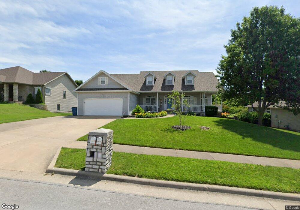
3738 N Mill Ridge Ave Springfield, MO 65803
Estimated Value: $389,000 - $441,000
4
Beds
3
Baths
3,308
Sq Ft
$123/Sq Ft
Est. Value
About This Home
This home is located at 3738 N Mill Ridge Ave, Springfield, MO 65803 and is currently estimated at $406,134, approximately $122 per square foot. 3738 N Mill Ridge Ave is a home located in Greene County with nearby schools including Pleasant View Elementary School, Pleasant View K-8 School, and Hillcrest High School.
Ownership History
Date
Name
Owned For
Owner Type
Purchase Details
Closed on
May 20, 2020
Sold by
Wilson Gary W and Wilson Lisa J
Bought by
Demers Thomas R and Demers Laura L
Current Estimated Value
Home Financials for this Owner
Home Financials are based on the most recent Mortgage that was taken out on this home.
Original Mortgage
$256,500
Outstanding Balance
$226,796
Interest Rate
3.3%
Mortgage Type
New Conventional
Estimated Equity
$179,338
Create a Home Valuation Report for This Property
The Home Valuation Report is an in-depth analysis detailing your home's value as well as a comparison with similar homes in the area
Home Values in the Area
Average Home Value in this Area
Purchase History
| Date | Buyer | Sale Price | Title Company |
|---|---|---|---|
| Demers Thomas R | -- | None Available |
Source: Public Records
Mortgage History
| Date | Status | Borrower | Loan Amount |
|---|---|---|---|
| Open | Demers Thomas R | $256,500 |
Source: Public Records
Tax History Compared to Growth
Tax History
| Year | Tax Paid | Tax Assessment Tax Assessment Total Assessment is a certain percentage of the fair market value that is determined by local assessors to be the total taxable value of land and additions on the property. | Land | Improvement |
|---|---|---|---|---|
| 2025 | $2,848 | $55,520 | $7,700 | $47,820 |
| 2024 | $2,848 | $49,190 | $5,700 | $43,490 |
| 2023 | $2,833 | $49,190 | $5,700 | $43,490 |
| 2022 | $2,604 | $44,310 | $5,700 | $38,610 |
| 2021 | $2,491 | $44,310 | $5,700 | $38,610 |
| 2020 | $2,515 | $42,470 | $5,700 | $36,770 |
| 2019 | $2,444 | $42,470 | $5,700 | $36,770 |
| 2018 | $2,431 | $42,030 | $5,320 | $36,710 |
| 2017 | $2,409 | $42,030 | $5,320 | $36,710 |
| 2016 | $2,404 | $42,030 | $5,320 | $36,710 |
| 2015 | $2,387 | $42,030 | $5,320 | $36,710 |
| 2014 | $2,356 | $41,520 | $5,320 | $36,200 |
Source: Public Records
Map
Nearby Homes
- Lot 1 E Stoneridge Dr
- 3481 N Marwin Ave
- 3839 N Stewart Ave
- 4260 N State Highway H
- 0 N State Highway H Unit 60272431
- 4159 N Farm Road 173
- 3749 N Pickwick Ave
- 3753 N Pickwick Ave
- 1464 E Burntwood St
- 4541b N Lanier Ln
- 4541 N Lanier Ln
- 3320 N Weller Ave
- 1338 E Burntwood St
- 1439 E McClernon St
- 1270 E Ogorman Ct
- 1425 E McClernon St
- 3957 N Springlawn Ave
- 1214 Evington Ct
- 1316 E Smith St
- 1255 E Smith St
- 3726 N Mill Ridge Ave
- 3750 N Mill Ridge Ave
- 3759 N Valley Place
- 3765 N Valley Place
- 3762 N Mill Ridge Ave
- 3739 N Mill Ridge Ave
- 3727 N Mill Ridge Ave
- 3751 N Mill Ridge Ave
- 3762 N Valley Place
- 3774 N Mill Ridge Ave
- 3763 N Mill Ridge Ave
- 1996 E Wheatridge Dr
- 2010 E Stoneridge Dr
- 0 N Valley Place
- 3736 N Nias Ave
- 1978 E Wheatridge Dr
- 3768 N Valley Place
- 3748 N Nias Ave
- 2004 E Stoneridge Dr
- 3760 N Nias Ave