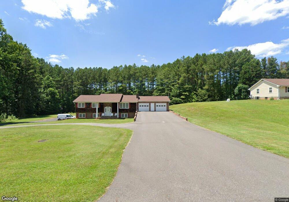
374 Black Mountain Rd Pilot Mountain, NC 27041
Estimated Value: $163,754 - $223,000
2
Beds
1
Bath
1,018
Sq Ft
$191/Sq Ft
Est. Value
About This Home
This home is located at 374 Black Mountain Rd, Pilot Mountain, NC 27041 and is currently estimated at $194,689, approximately $191 per square foot. 374 Black Mountain Rd is a home with nearby schools including Pilot Mountain Elementary School, Pilot Mountain Middle School, and East Surry High School.
Ownership History
Date
Name
Owned For
Owner Type
Purchase Details
Closed on
Apr 1, 2013
Sold by
King Deanna Wilmoth and King Clark M
Bought by
Knopf Christopher M and Knopf Amy C
Current Estimated Value
Purchase Details
Closed on
Mar 28, 2013
Sold by
Knopf Christopher M and Knopf Amy C
Bought by
Culler Roy A and Culler Jean A
Purchase Details
Closed on
Sep 24, 2007
Sold by
King Deanna Wilmoth and King Clark M
Bought by
King Deanna Wilmoth and King Clark M
Purchase Details
Closed on
Apr 13, 2007
Sold by
Wilmoth Buster L and Wilmoth Shirley W
Bought by
King Deanna Wilmoth
Purchase Details
Closed on
Jun 1, 1983
Purchase Details
Closed on
Sep 1, 1977
Create a Home Valuation Report for This Property
The Home Valuation Report is an in-depth analysis detailing your home's value as well as a comparison with similar homes in the area
Home Values in the Area
Average Home Value in this Area
Purchase History
| Date | Buyer | Sale Price | Title Company |
|---|---|---|---|
| Knopf Christopher M | $84,000 | None Available | |
| Culler Roy A | -- | None Available | |
| King Deanna Wilmoth | -- | Chicago Title Insurance Comp | |
| King Deanna Wilmoth | -- | Chicago Title Insurance Comp | |
| -- | -- | -- | |
| -- | -- | -- |
Source: Public Records
Tax History Compared to Growth
Tax History
| Year | Tax Paid | Tax Assessment Tax Assessment Total Assessment is a certain percentage of the fair market value that is determined by local assessors to be the total taxable value of land and additions on the property. | Land | Improvement |
|---|---|---|---|---|
| 2025 | $641 | $109,210 | $42,480 | $66,730 |
| 2024 | $592 | $91,940 | $46,020 | $45,920 |
| 2023 | $581 | $91,940 | $46,020 | $45,920 |
| 2022 | $581 | $91,940 | $46,020 | $45,920 |
| 2021 | $592 | $91,940 | $46,020 | $45,920 |
| 2020 | $571 | $84,510 | $42,480 | $42,030 |
| 2019 | $568 | $84,510 | $0 | $0 |
| 2018 | $558 | $84,510 | $0 | $0 |
| 2017 | $565 | $84,510 | $0 | $0 |
| 2016 | $565 | $84,510 | $0 | $0 |
| 2013 | -- | $83,270 | $0 | $0 |
Source: Public Records
Map
Nearby Homes
- TBD Golf Course Rd
- 0 S Key St
- 00 Whitaker Chapel Rd Unit 2
- 00 Whitaker Chapel Rd Unit 1
- 00 Whitaker Chapel Rd Unit 10
- 0 Heatherly Creek Dr
- TBD S Key St
- 00 Deer Trace Ln
- 267 Pine Ridge Trail
- 104 Windover Dr
- 0 Pine Ridge Trail
- 522 Butler St
- 502 S Key St
- o N Carolina 268
- 00 Golf Course Rd
- 402 Lynchburg Rd
- 267 S Boyles St
- 261 S Boyles St
- 205 S Key St
- 225 E Main St
- 394 Black Mountain Rd
- 440 Black Mountain Rd
- 122 Gotham Ln
- 283 Mountain Loop Rd
- 505 Black Mountain Rd
- 512 Black Mountain Rd
- 225 Mountain Loop Rd
- 163 Mountain Loop Rd
- 157 Queen St
- 194 Mountain Loop Rd
- 00 Stone Dr
- 536 Black Mountain Rd
- 2.84 Acres Stone Dr
- 140 Hidden Vista Ln
- 539 Black Mountain Rd
- 212 Stone Dr
- 149 Queen St
- 216 Friendly Ln
- 198 Stone Dr
- 158 Queen St