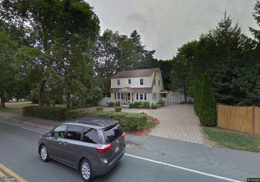
374 Weston Rd Unit 374 Wellesley, MA 02482
Estimated Value: $1,301,000 - $1,486,451
4
Beds
2
Baths
1,627
Sq Ft
$862/Sq Ft
Est. Value
About This Home
This home is located at 374 Weston Rd Unit 374, Wellesley, MA 02482 and is currently estimated at $1,402,113, approximately $861 per square foot. 374 Weston Rd Unit 374 is a home located in Norfolk County with nearby schools including Katharine Lee Bates Elementary School, Wellesley Middle School, and Wellesley Sr High School.
Ownership History
Date
Name
Owned For
Owner Type
Purchase Details
Closed on
Aug 30, 2025
Sold by
Avakian Adam and Kremen Jessica
Bought by
374 Weston Road Rt and Pearce
Current Estimated Value
Purchase Details
Closed on
Apr 26, 2024
Sold by
Mcmahon Eamon T
Bought by
Avakian Adam and Kremen Jessica
Home Financials for this Owner
Home Financials are based on the most recent Mortgage that was taken out on this home.
Original Mortgage
$1,105,000
Interest Rate
6.63%
Mortgage Type
Purchase Money Mortgage
Purchase Details
Closed on
Oct 26, 2018
Sold by
Mcmahon Eamon T and Rafferty Pamela
Bought by
Mcmahon Eamon T
Purchase Details
Closed on
Aug 24, 2007
Sold by
Biela Bernardeta D
Bought by
Mcmahon Eamon T and Mcmahon Pamela J
Home Financials for this Owner
Home Financials are based on the most recent Mortgage that was taken out on this home.
Original Mortgage
$536,000
Interest Rate
6.78%
Mortgage Type
Purchase Money Mortgage
Purchase Details
Closed on
Jun 1, 2005
Sold by
Goss John and Goss Lynn
Bought by
Biela Bernadeta D and Biela Marek
Create a Home Valuation Report for This Property
The Home Valuation Report is an in-depth analysis detailing your home's value as well as a comparison with similar homes in the area
Home Values in the Area
Average Home Value in this Area
Purchase History
| Date | Buyer | Sale Price | Title Company |
|---|---|---|---|
| 374 Weston Road Rt | -- | -- | |
| Avakian Adam | $1,300,000 | None Available | |
| Mcmahon Eamon T | -- | -- | |
| Mcmahon Eamon T | -- | -- | |
| Mcmahon Eamon T | $670,000 | -- | |
| Mcmahon Eamon T | $670,000 | -- | |
| Mcmahon Eamon T | $670,000 | -- | |
| Biela Bernadeta D | $630,000 | -- | |
| Biela Bernadeta D | $630,000 | -- | |
| Biela Bernadeta D | $630,000 | -- |
Source: Public Records
Mortgage History
| Date | Status | Borrower | Loan Amount |
|---|---|---|---|
| Previous Owner | Avakian Adam | $1,105,000 | |
| Previous Owner | Biela Bernadeta D | $465,000 | |
| Previous Owner | Mcmahon Eamon T | $536,000 | |
| Previous Owner | Mcmahon Eamon T | $67,000 |
Source: Public Records
Tax History Compared to Growth
Tax History
| Year | Tax Paid | Tax Assessment Tax Assessment Total Assessment is a certain percentage of the fair market value that is determined by local assessors to be the total taxable value of land and additions on the property. | Land | Improvement |
|---|---|---|---|---|
| 2025 | $12,285 | $1,195,000 | $1,007,000 | $188,000 |
| 2024 | $11,399 | $1,095,000 | $911,000 | $184,000 |
| 2023 | $11,633 | $1,016,000 | $860,000 | $156,000 |
| 2022 | $10,372 | $888,000 | $670,000 | $218,000 |
| 2021 | $10,434 | $888,000 | $670,000 | $218,000 |
| 2020 | $10,265 | $888,000 | $670,000 | $218,000 |
| 2019 | $10,274 | $888,000 | $670,000 | $218,000 |
| 2018 | $8,915 | $746,000 | $591,000 | $155,000 |
| 2017 | $8,795 | $746,000 | $591,000 | $155,000 |
| 2016 | $8,660 | $732,000 | $581,000 | $151,000 |
| 2015 | $7,722 | $668,000 | $523,000 | $145,000 |
Source: Public Records
Map
Nearby Homes