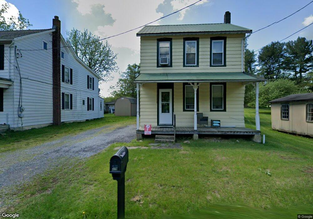
377 Lowland Rd Hamburg, PA 19526
Estimated Value: $230,357 - $285,000
3
Beds
1
Bath
1,596
Sq Ft
$164/Sq Ft
Est. Value
About This Home
This home is located at 377 Lowland Rd, Hamburg, PA 19526 and is currently estimated at $262,089, approximately $164 per square foot. 377 Lowland Rd is a home located in Berks County with nearby schools including Hamburg Area High School, Blue Mountain Seventh-day Adventist Elementary School, and Blue Mountain Academy.
Ownership History
Date
Name
Owned For
Owner Type
Purchase Details
Closed on
Dec 28, 2007
Sold by
Tlc Real Estate Solutions Inc
Bought by
Merkel Jacki L and Kutzler Paul E
Current Estimated Value
Home Financials for this Owner
Home Financials are based on the most recent Mortgage that was taken out on this home.
Original Mortgage
$145,000
Outstanding Balance
$92,050
Interest Rate
6.27%
Mortgage Type
Purchase Money Mortgage
Estimated Equity
$170,039
Purchase Details
Closed on
Jul 31, 2006
Sold by
Utsch Jeffrey T
Bought by
Susquehanna Patriot Bank
Purchase Details
Closed on
Nov 23, 2004
Sold by
Wetzel John F and Wetzel Gloria A
Bought by
Utsch Jeffrey T
Home Financials for this Owner
Home Financials are based on the most recent Mortgage that was taken out on this home.
Original Mortgage
$106,000
Interest Rate
5.81%
Mortgage Type
Fannie Mae Freddie Mac
Create a Home Valuation Report for This Property
The Home Valuation Report is an in-depth analysis detailing your home's value as well as a comparison with similar homes in the area
Home Values in the Area
Average Home Value in this Area
Purchase History
| Date | Buyer | Sale Price | Title Company |
|---|---|---|---|
| Merkel Jacki L | $145,000 | None Available | |
| Susquehanna Patriot Bank | -- | None Available | |
| Utsch Jeffrey T | $106,000 | Fidelity Natl Title Ins Co |
Source: Public Records
Mortgage History
| Date | Status | Borrower | Loan Amount |
|---|---|---|---|
| Open | Merkel Jacki L | $145,000 | |
| Previous Owner | Utsch Jeffrey T | $106,000 |
Source: Public Records
Tax History Compared to Growth
Tax History
| Year | Tax Paid | Tax Assessment Tax Assessment Total Assessment is a certain percentage of the fair market value that is determined by local assessors to be the total taxable value of land and additions on the property. | Land | Improvement |
|---|---|---|---|---|
| 2025 | $711 | $62,600 | $27,800 | $34,800 |
| 2024 | $2,357 | $62,600 | $27,800 | $34,800 |
| 2023 | $2,305 | $62,600 | $27,800 | $34,800 |
| 2022 | $2,298 | $62,600 | $27,800 | $34,800 |
| 2021 | $2,298 | $62,600 | $27,800 | $34,800 |
| 2020 | $2,298 | $62,600 | $27,800 | $34,800 |
| 2019 | $2,305 | $62,600 | $27,800 | $34,800 |
| 2018 | $2,258 | $62,600 | $27,800 | $34,800 |
| 2017 | $2,224 | $62,600 | $27,800 | $34,800 |
| 2016 | $552 | $62,600 | $27,800 | $34,800 |
| 2015 | $541 | $62,600 | $27,800 | $34,800 |
| 2014 | $541 | $62,600 | $27,800 | $34,800 |
Source: Public Records
Map
Nearby Homes
- 379 Lowland Rd
- 371 Lowland Rd
- 385 Lowland Rd
- 363 Lowland Rd
- 361 Lowland Rd
- 351 Lowland Rd
- 0 Lowland Rd
- 337 Lowland Rd
- 333 Lowland Rd
- 323 Lowland Rd
- 920 Port Clinton Ave
- 311 Lowland Rd
- 1010 Port Clinton Ave
- 915 Port Clinton Ave
- 40 Mountain Ln
- 1014 Port Clinton Ave
- 463 Lowland Rd
- 722 Port Clinton Ave
- 1018 Port Clinton Ave
- 462 Lowland Rd