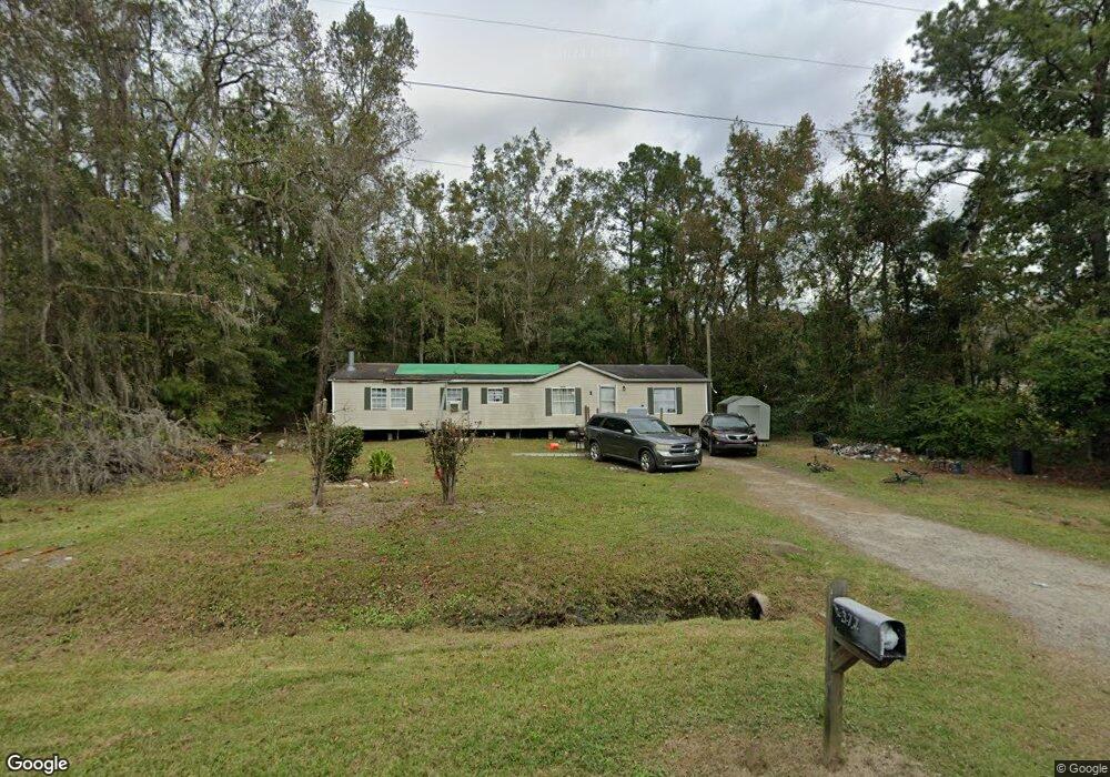
377 Screven Fork Rd Midway, GA 31320
Estimated Value: $89,590 - $353,000
3
Beds
1
Bath
943
Sq Ft
$209/Sq Ft
Est. Value
About This Home
This home is located at 377 Screven Fork Rd, Midway, GA 31320 and is currently estimated at $197,148, approximately $209 per square foot. 377 Screven Fork Rd is a home located in Liberty County with nearby schools including Liberty Elementary School, Midway Middle School, and Liberty County High School.
Ownership History
Date
Name
Owned For
Owner Type
Purchase Details
Closed on
Feb 27, 2014
Sold by
Bradley Norma J
Bought by
Groover Deborah Strickland
Current Estimated Value
Purchase Details
Closed on
Oct 10, 2012
Sold by
Spartan Mtg Inc
Bought by
Bradley Norma J
Purchase Details
Closed on
Apr 21, 1997
Bought by
Robertson Gwendolyn Y
Purchase Details
Closed on
Mar 15, 1996
Bought by
Robertson Gwendolyn Y
Purchase Details
Closed on
Sep 8, 1995
Bought by
Jarrideau Lucille
Purchase Details
Closed on
Apr 1, 1972
Bought by
Jarrideau William
Create a Home Valuation Report for This Property
The Home Valuation Report is an in-depth analysis detailing your home's value as well as a comparison with similar homes in the area
Home Values in the Area
Average Home Value in this Area
Purchase History
| Date | Buyer | Sale Price | Title Company |
|---|---|---|---|
| Groover Deborah Strickland | -- | -- | |
| Bradley Norma J | -- | -- | |
| Robertson Gwendolyn Y | -- | -- | |
| Robertson Gwendolyn Y | -- | -- | |
| Jarrideau Lucille | -- | -- | |
| Jarrideau William | -- | -- |
Source: Public Records
Tax History Compared to Growth
Tax History
| Year | Tax Paid | Tax Assessment Tax Assessment Total Assessment is a certain percentage of the fair market value that is determined by local assessors to be the total taxable value of land and additions on the property. | Land | Improvement |
|---|---|---|---|---|
| 2024 | $210 | $4,968 | $4,916 | $52 |
| 2023 | $191 | $4,962 | $4,916 | $46 |
| 2022 | $191 | $4,952 | $4,916 | $36 |
| 2021 | $190 | $4,948 | $4,916 | $32 |
| 2020 | $191 | $4,948 | $4,916 | $32 |
| 2019 | $186 | $4,948 | $4,916 | $32 |
| 2018 | $183 | $4,948 | $4,916 | $32 |
| 2017 | $163 | $4,948 | $4,916 | $32 |
| 2016 | $171 | $4,947 | $4,916 | $32 |
Source: Public Records
Map
Nearby Homes
- 176 Dave Williams Rd
- 2 Acres Walthour Rd
- 8578 E B Cooper Hwy
- 7337 E Oglethorpe Hwy
- 8701 E Oglethorpe Hwy
- 6228 E Oglethorpe Hwy
- 296 River Bend Dr
- 1.0 Acre Holmestown Rd
- 1 Acre Holmestown Rd
- 0 E Oglethorpe Unit SA341930
- 0 E Oglethorpe Unit 153327
- 0 E Oglethorpe Unit 10592168
- 327 River Bend Dr
- 364 River Bend Dr
- 223 Claudia Ln
- 21 Smiley Loop Rd
- 1123 Stone Ct
- 211 Smiley Loop Rd
- 90 Charleston Ct
- 984 Stone Ct
- 353 Screven Fork Rd
- 413 Screven Fork Rd
- 301 Screven Fork Rd
- 86 Screven Fork Rd
- 0 Screven Fork Rd Unit 36132
- 0 Screven Fork Rd Unit 112959
- 0 Screven Fork Rd Unit 112958
- 545 Screven Fork Rd
- 2959 Lewis Frasier Rd
- 183 Screven Fork Rd
- 2801 Lewis Frasier Rd
- 2997 Lewis Frasier Rd
- - Bill Carter Rd
- 2950 Lewis Frasier Rd
- 641 Screven Fork Rd
- 265 Kings Rd
- 741 Screven Fork Rd
- 2707 Lewis Frasier Rd
- 3142 Lewis Frasier Rd
- 755 Screven Fork Rd