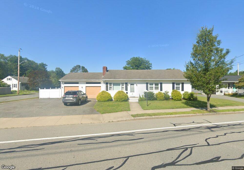
3773 Acushnet Ave New Bedford, MA 02745
Estimated Value: $460,000 - $500,514
3
Beds
2
Baths
1,568
Sq Ft
$308/Sq Ft
Est. Value
About This Home
This home is located at 3773 Acushnet Ave, New Bedford, MA 02745 and is currently estimated at $482,629, approximately $307 per square foot. 3773 Acushnet Ave is a home located in Bristol County with nearby schools including Casimir Pulaski Elementary School, Normandin Middle School, and New Bedford High School.
Ownership History
Date
Name
Owned For
Owner Type
Purchase Details
Closed on
Nov 12, 2014
Sold by
Antao Maximino C and Antao Maria L
Bought by
Antao Ft and Antao
Current Estimated Value
Purchase Details
Closed on
Jul 30, 2010
Sold by
1St Citizens Fcu
Bought by
Antao Maximino C and Antao Maria L
Purchase Details
Closed on
Jun 24, 2010
Sold by
Bois Andrew G and First Citizens Fcu
Bought by
First Citizens Fcu
Purchase Details
Closed on
Dec 26, 1997
Sold by
Sa Acacio S
Bought by
Bois Andrew G
Purchase Details
Closed on
Sep 23, 1988
Sold by
Sa Ema
Bought by
Sa Acacio S
Create a Home Valuation Report for This Property
The Home Valuation Report is an in-depth analysis detailing your home's value as well as a comparison with similar homes in the area
Home Values in the Area
Average Home Value in this Area
Purchase History
| Date | Buyer | Sale Price | Title Company |
|---|---|---|---|
| Antao Ft | -- | -- | |
| Antao Ft | -- | -- | |
| Antao Maximino C | $182,500 | -- | |
| Antao Maximino C | $182,500 | -- | |
| First Citizens Fcu | $99,000 | -- | |
| First Citizens Fcu | $99,000 | -- | |
| Bois Andrew G | $150,000 | -- | |
| Bois Andrew G | $150,000 | -- | |
| Sa Acacio S | $85,000 | -- |
Source: Public Records
Mortgage History
| Date | Status | Borrower | Loan Amount |
|---|---|---|---|
| Previous Owner | Sa Acacio S | $186,500 | |
| Previous Owner | Sa Acacio S | $116,000 |
Source: Public Records
Tax History Compared to Growth
Tax History
| Year | Tax Paid | Tax Assessment Tax Assessment Total Assessment is a certain percentage of the fair market value that is determined by local assessors to be the total taxable value of land and additions on the property. | Land | Improvement |
|---|---|---|---|---|
| 2025 | $5,121 | $452,800 | $135,400 | $317,400 |
| 2024 | $4,962 | $413,500 | $126,900 | $286,600 |
| 2023 | $4,919 | $344,200 | $107,900 | $236,300 |
| 2022 | $4,681 | $301,200 | $107,900 | $193,300 |
| 2021 | $4,562 | $292,600 | $105,800 | $186,800 |
| 2020 | $4,619 | $285,800 | $105,800 | $180,000 |
| 2019 | $4,472 | $271,500 | $105,800 | $165,700 |
| 2018 | $4,196 | $252,300 | $105,800 | $146,500 |
| 2017 | $3,994 | $239,300 | $103,600 | $135,700 |
| 2016 | $3,585 | $217,400 | $95,200 | $122,200 |
| 2015 | $3,347 | $212,800 | $93,100 | $119,700 |
| 2014 | $3,270 | $215,700 | $95,200 | $120,500 |
Source: Public Records
Map
Nearby Homes
- SS Charbonneau Ln
- 1063 Westgate St
- 145 Heritage Dr
- 34 Poplar Rd
- 62 Longview Rd
- 210 Heritage Dr
- 64 Blaze Rd
- 26 Blueberry Dr
- 1269 Bartlett St
- 8 Holly Tree Ln
- 12 Randall St
- 700 Pine Hill Dr
- 888 Hillcrest Rd
- 1069 Cherokee St
- 1045 Forbes St
- 2 Woodland Rd
- 16 Swallow St
- 13 Luscomb Ln
- 1350 Phillips Rd
- ES Acushnet Ave
- 1015 Beverly St
- 3783 Acushnet Ave
- 3759 Acushnet Ave
- 1016 Beverly St
- 3782 Acushnet Ave
- 3770 Acushnet Ave
- 1027 Beverly St
- 3792 Acushnet Ave
- 1028 Beverly St
- 1024 Churchill St
- 3762 Acushnet Ave
- 3799 Acushnet Ave
- 3747 Acushnet Ave
- 1028 Churchill St
- 3806 Acushnet Ave
- 988 Beverly St
- 1017 Churchill St
- 3748 Acushnet Ave
- 3811 Acushnet Ave
- 1045 Beverly St