Estimated Value: $350,000 - $752,000
3
Beds
3
Baths
2,100
Sq Ft
$267/Sq Ft
Est. Value
About This Home
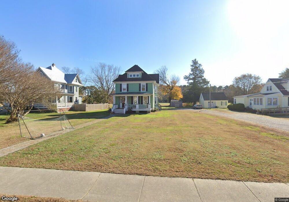
This home is located at 3778 Weems Rd, Weems, VA 22576 and is currently estimated at $560,714, approximately $267 per square foot. 3778 Weems Rd is a home located in Lancaster County with nearby schools including Lancaster Primary School, Lancaster Middle School, and Lancaster High School.
Ownership History
Date
Name
Owned For
Owner Type
Purchase Details
Closed on
Dec 21, 2017
Sold by
Par Llc A Virginia Limited Liability Com
Bought by
Pittman Robert E and Pittman Sarah Elizabeth
Current Estimated Value
Home Financials for this Owner
Home Financials are based on the most recent Mortgage that was taken out on this home.
Original Mortgage
$215,000
Outstanding Balance
$180,065
Interest Rate
3.92%
Mortgage Type
Commercial
Estimated Equity
$380,649
Purchase Details
Closed on
Jun 1, 2015
Sold by
Blunt John D and Blunt Janet M
Bought by
Par Llc
Purchase Details
Closed on
Sep 15, 2008
Sold by
Cockrell Genevieve W
Bought by
Blunt John D
Create a Home Valuation Report for This Property
The Home Valuation Report is an in-depth analysis detailing your home's value as well as a comparison with similar homes in the area
Purchase History
| Date | Buyer | Sale Price | Title Company |
|---|---|---|---|
| Pittman Robert E | $300,000 | Lawyers Title Mid Peninsula | |
| Par Llc | -- | None Available | |
| Blunt John D | $135,500 | -- |
Source: Public Records
Mortgage History
| Date | Status | Borrower | Loan Amount |
|---|---|---|---|
| Open | Pittman Robert E | $215,000 |
Source: Public Records
Tax History
| Year | Tax Paid | Tax Assessment Tax Assessment Total Assessment is a certain percentage of the fair market value that is determined by local assessors to be the total taxable value of land and additions on the property. | Land | Improvement |
|---|---|---|---|---|
| 2025 | $2,235 | $406,400 | $31,600 | $374,800 |
| 2024 | $2,235 | $406,400 | $31,600 | $374,800 |
| 2023 | $1,664 | $264,100 | $31,600 | $232,500 |
| 2022 | $1,664 | $264,100 | $31,600 | $232,500 |
| 2021 | $1,664 | $264,100 | $31,600 | $232,500 |
| 2020 | $1,664 | $264,100 | $31,600 | $232,500 |
| 2019 | $1,664 | $264,100 | $31,600 | $232,500 |
| 2018 | $1,137 | $192,700 | $18,100 | $174,600 |
| 2017 | $1,137 | $192,700 | $18,100 | $174,600 |
| 2016 | -- | $192,700 | $18,100 | $174,600 |
| 2014 | -- | $0 | $0 | $0 |
| 2013 | -- | $0 | $0 | $0 |
Source: Public Records
Map
Nearby Homes
- 3755 Weems Rd
- 289 King Carter Ln
- 19 Wharton Grove Ln
- 176 King Carter Ln
- Map 3324C Sunset Dr
- 12 Benson Rd
- Lot 16 Cedar Pointe Dr
- 783 King Carter Dr
- 212 Gordon Dr
- 0 Yopps Cove Rd
- 108 Spindrift Rd
- 44 Muirfield Ct
- 391 Steamboat Rd
- 370 King Carter Dr
- TM27223C York Rd
- 182 King Carter Dr
- 924 Indiantown Rd
- 48 Steamboat Rd
- 40 Cedardale Ln
- 147 Sir Guy Dr
Your Personal Tour Guide
Ask me questions while you tour the home.