Estimated Value: $843,000 - $970,000
3
Beds
3
Baths
1,970
Sq Ft
$469/Sq Ft
Est. Value
About This Home
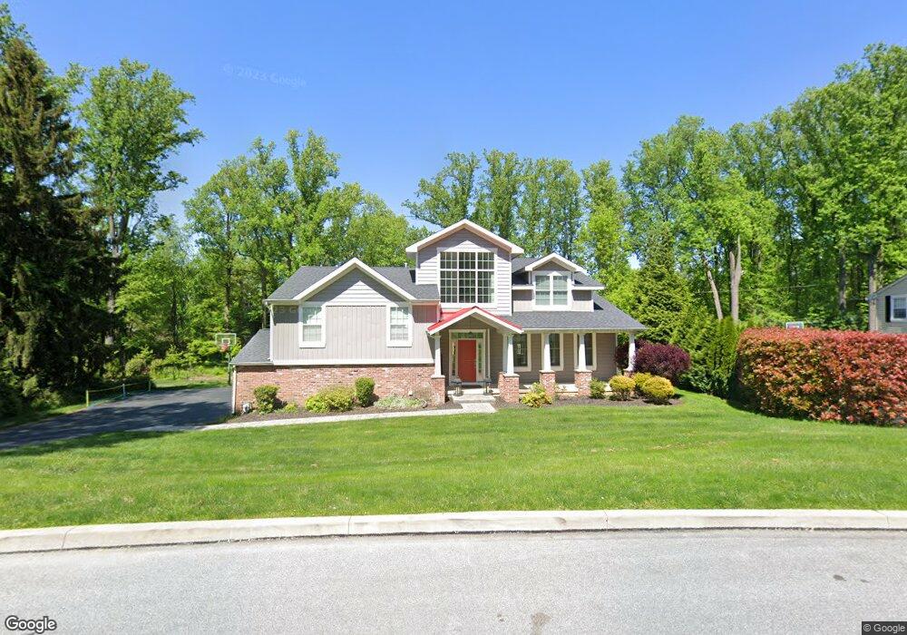
This home is located at 378 Friendship Dr, Paoli, PA 19301 and is currently estimated at $924,208, approximately $469 per square foot. 378 Friendship Dr is a home located in Chester County with nearby schools including Hillside Elementary School, Valley Forge Middle School, and Conestoga Senior High School.
Ownership History
Date
Name
Owned For
Owner Type
Purchase Details
Closed on
Oct 21, 2011
Sold by
Martin David L and Martin Evyonne M
Bought by
Dunn Thomas J and Dunn Lindsey R
Current Estimated Value
Home Financials for this Owner
Home Financials are based on the most recent Mortgage that was taken out on this home.
Original Mortgage
$285,000
Outstanding Balance
$192,686
Interest Rate
3.92%
Mortgage Type
New Conventional
Estimated Equity
$731,522
Create a Home Valuation Report for This Property
The Home Valuation Report is an in-depth analysis detailing your home's value as well as a comparison with similar homes in the area
Home Values in the Area
Average Home Value in this Area
Purchase History
| Date | Buyer | Sale Price | Title Company |
|---|---|---|---|
| Dunn Thomas J | $357,000 | None Available |
Source: Public Records
Mortgage History
| Date | Status | Borrower | Loan Amount |
|---|---|---|---|
| Open | Dunn Thomas J | $285,000 |
Source: Public Records
Tax History Compared to Growth
Tax History
| Year | Tax Paid | Tax Assessment Tax Assessment Total Assessment is a certain percentage of the fair market value that is determined by local assessors to be the total taxable value of land and additions on the property. | Land | Improvement |
|---|---|---|---|---|
| 2025 | $10,145 | $288,030 | $85,900 | $202,130 |
| 2024 | $10,145 | $288,030 | $85,900 | $202,130 |
| 2023 | $9,530 | $288,030 | $85,900 | $202,130 |
| 2022 | $9,284 | $288,030 | $85,900 | $202,130 |
| 2021 | $9,108 | $288,030 | $85,900 | $202,130 |
| 2020 | $8,856 | $288,030 | $85,900 | $202,130 |
| 2019 | $8,577 | $288,030 | $85,900 | $202,130 |
| 2018 | $8,407 | $288,030 | $85,900 | $202,130 |
| 2017 | $6,185 | $217,090 | $85,900 | $131,190 |
| 2016 | -- | $217,090 | $85,900 | $131,190 |
| 2015 | -- | $217,090 | $85,900 | $131,190 |
| 2014 | -- | $217,090 | $85,900 | $131,190 |
Source: Public Records
Map
Nearby Homes
- 109 Vincent Rd
- 202 Shoreline Dr
- 1250 Swedesford Rd
- 5 Kent Ln
- 1242 Old Lancaster Rd
- 106 N Valley Rd
- 1 Whitworth Ave
- 211 Wooded Way
- 1441 Berwyn Paoli Rd
- 521 Foxwood Ln
- 2102 Quail Ridge Dr
- 896 Conestoga Rd
- 1304 Weatherstone Dr Unit 1304
- 32 Manchester Ct
- 1705 Weatherstone Dr
- 21 Manor Rd
- 29 Manor Rd
- 793 Tory Hollow Rd
- 104 Lynbrook Rd
- 12 Moreland Rd
- 382 Friendship Dr
- 374 Friendship Dr
- 375 Friendship Dr
- 386 Friendship Dr
- 383 Friendship Dr
- 428 Hilltop Rd
- 370 Friendship Dr
- 434 Hilltop Rd
- 367 Friendship Dr
- 474 Hilltop Rd
- 387 Friendship Dr
- 420 Hilltop Rd
- 366 Friendship Dr
- 442 Hilltop Rd
- 393 Friendship Dr
- 494 Hilltop Rd
- 404 Hilltop Rd
- 363 Friendship Dr
- 412 Hilltop Rd
- 504 Hilltop Rd