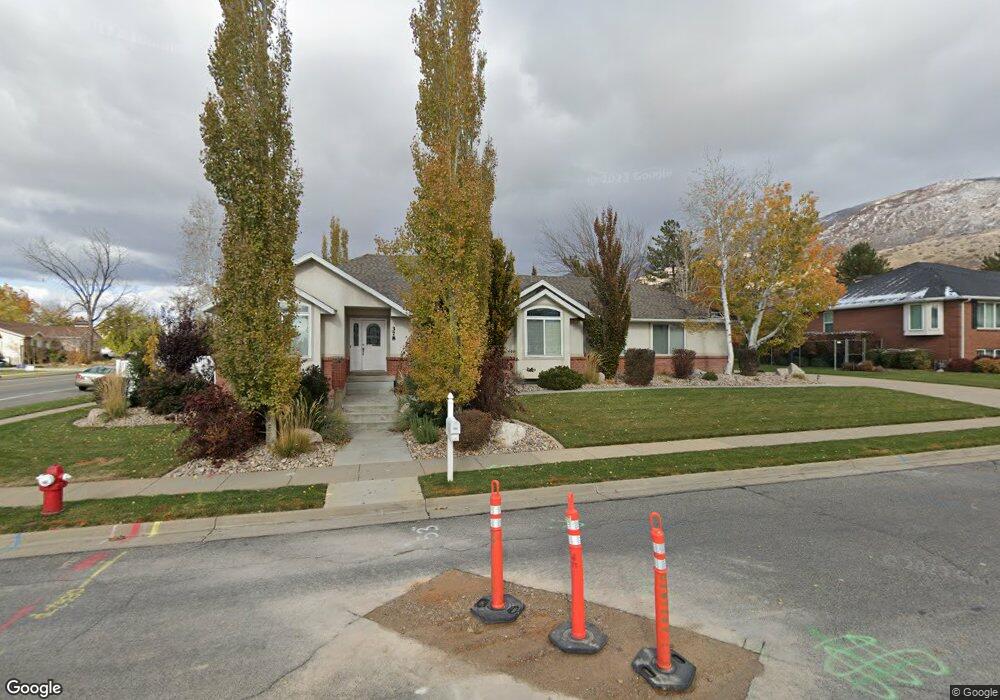
378 W 1450 N Centerville, UT 84014
Estimated Value: $639,000 - $850,000
5
Beds
3
Baths
4,379
Sq Ft
$175/Sq Ft
Est. Value
About This Home
This home is located at 378 W 1450 N, Centerville, UT 84014 and is currently estimated at $767,006, approximately $175 per square foot. 378 W 1450 N is a home located in Davis County with nearby schools including Stewart Elementary School, Centerville Jr High, and Viewmont High School.
Ownership History
Date
Name
Owned For
Owner Type
Purchase Details
Closed on
Jun 5, 2023
Sold by
Gibson Rodney R
Bought by
Rodney And Marian Gibson Living Trust
Current Estimated Value
Purchase Details
Closed on
Feb 11, 2011
Sold by
Hayes Robert S and Hayes Marie
Bought by
Gibson Rodney R and Gibson Marian
Home Financials for this Owner
Home Financials are based on the most recent Mortgage that was taken out on this home.
Original Mortgage
$218,000
Interest Rate
4.84%
Mortgage Type
Purchase Money Mortgage
Purchase Details
Closed on
Apr 23, 2003
Sold by
Hayes Marie
Bought by
Hayes Robert S and Hayes Marie
Purchase Details
Closed on
Dec 31, 2001
Sold by
Mitchell Robert C and Laree Mitchell K
Bought by
Mitchell Robert C and Mitchell Katherine Laree
Home Financials for this Owner
Home Financials are based on the most recent Mortgage that was taken out on this home.
Original Mortgage
$166,360
Interest Rate
6.73%
Create a Home Valuation Report for This Property
The Home Valuation Report is an in-depth analysis detailing your home's value as well as a comparison with similar homes in the area
Purchase History
We collect this data history from publicly available records. To have your information removed, we recommend requesting removal directly through your county’s website.
| Date | Buyer | Sale Price | Title Company |
|---|---|---|---|
| Rodney And Marian Gibson Living Trust | -- | None Listed On Document | |
| Gibson Rodney R | -- | Equity Title Ins Agency Inc | |
| Hayes Robert S | -- | Pinnacle Title | |
| Hayes Marie | -- | First American Title Co | |
| Mitchell Robert C | -- | Security Title Company |
Source: Public Records
Mortgage History
We collect this data history from publicly available records. To have your information removed, we recommend requesting removal directly through your county’s website.
| Date | Status | Borrower | Loan Amount |
|---|---|---|---|
| Previous Owner | Gibson Rodney R | $218,000 | |
| Previous Owner | Mitchell Robert C | $166,360 |
Source: Public Records
Tax History
| Year | Tax Paid | Tax Assessment Tax Assessment Total Assessment is a certain percentage of the fair market value that is determined by local assessors to be the total taxable value of land and additions on the property. | Land | Improvement |
|---|---|---|---|---|
| 2025 | $4,441 | $389,950 | $168,030 | $221,920 |
| 2024 | $4,242 | $379,500 | $154,250 | $225,250 |
| 2023 | $4,166 | $677,000 | $248,785 | $428,215 |
| 2022 | $4,332 | $390,500 | $126,482 | $264,018 |
| 2021 | $3,887 | $543,000 | $197,871 | $345,129 |
| 2020 | $3,589 | $500,000 | $190,829 | $309,171 |
| 2019 | $3,592 | $492,000 | $183,298 | $308,702 |
| 2018 | $3,368 | $456,000 | $169,654 | $286,346 |
| 2016 | $2,927 | $222,860 | $57,235 | $165,625 |
| 2015 | $2,911 | $209,275 | $57,235 | $152,040 |
| 2014 | $2,712 | $198,879 | $57,235 | $141,644 |
| 2013 | -- | $181,202 | $45,935 | $135,267 |
Source: Public Records
Map
Nearby Homes
Your Personal Tour Guide
Ask me questions while you tour the home.