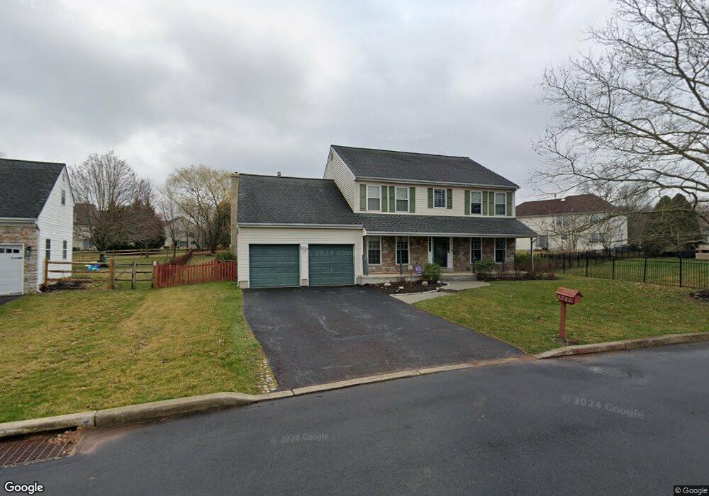
3785 Daystar Dr Doylestown, PA 18902
Estimated Value: $788,268 - $898,000
4
Beds
3
Baths
2,596
Sq Ft
$327/Sq Ft
Est. Value
About This Home
This home is located at 3785 Daystar Dr, Doylestown, PA 18902 and is currently estimated at $848,817, approximately $326 per square foot. 3785 Daystar Dr is a home located in Bucks County with nearby schools including Cold Spring Elementary School, Holicong Middle School, and Central Bucks High School - East.
Ownership History
Date
Name
Owned For
Owner Type
Purchase Details
Closed on
Dec 7, 1994
Sold by
Barnside Development Company
Bought by
Mccaul Dermot and Mccaul Elizabeth
Current Estimated Value
Home Financials for this Owner
Home Financials are based on the most recent Mortgage that was taken out on this home.
Original Mortgage
$188,000
Interest Rate
9.2%
Create a Home Valuation Report for This Property
The Home Valuation Report is an in-depth analysis detailing your home's value as well as a comparison with similar homes in the area
Home Values in the Area
Average Home Value in this Area
Purchase History
| Date | Buyer | Sale Price | Title Company |
|---|---|---|---|
| Mccaul Dermot | $209,150 | -- |
Source: Public Records
Mortgage History
| Date | Status | Borrower | Loan Amount |
|---|---|---|---|
| Closed | Mccaul Dermot | $188,000 |
Source: Public Records
Tax History Compared to Growth
Tax History
| Year | Tax Paid | Tax Assessment Tax Assessment Total Assessment is a certain percentage of the fair market value that is determined by local assessors to be the total taxable value of land and additions on the property. | Land | Improvement |
|---|---|---|---|---|
| 2025 | $6,838 | $42,000 | $10,280 | $31,720 |
| 2024 | $6,838 | $42,000 | $10,280 | $31,720 |
| 2023 | $6,606 | $42,000 | $10,280 | $31,720 |
| 2022 | $6,527 | $42,000 | $10,280 | $31,720 |
| 2021 | $6,449 | $42,000 | $10,280 | $31,720 |
| 2020 | $6,449 | $42,000 | $10,280 | $31,720 |
| 2019 | $6,407 | $42,000 | $10,280 | $31,720 |
| 2018 | $6,407 | $42,000 | $10,280 | $31,720 |
| 2017 | $6,355 | $42,000 | $10,280 | $31,720 |
| 2016 | $6,418 | $42,000 | $10,280 | $31,720 |
| 2015 | -- | $42,000 | $10,280 | $31,720 |
| 2014 | -- | $42,000 | $10,280 | $31,720 |
Source: Public Records
Map
Nearby Homes
- 5063 Sagewood Ct
- 5115 Sugar Hill Ct
- 3975 Amberton Ct
- 5281 Harrington Ct
- 3479 Durham Rd
- 3455 Durham Rd
- 3468 Holicong Rd
- 4936 Davis Dr
- 4925 Redfield Rd
- 3689 Hancock Ln
- 4928 Edgewood Rd
- 5491 Long Ln
- 4250 Aly Dr
- 4605 Twinbrook Cir
- 5110 Harmony Ct W
- 3865 Burnt House Hill Rd
- 4542 Deep Creek Way
- 4201 Sir Andrew Cir
- 4871 E Blossom Dr
- 4190 Milords Ln
- 3791 Daystar Dr
- 5026 Rosewood Dr
- 5034 Rosewood Dr
- 5012 Rosewood Dr
- 3797 Daystar Dr
- 5026 Sundance Ct
- 5042 Rosewood Dr
- 5056 Raintree Ct
- 5058 Raintree Ct
- 5060 Raintree Ct
- 5062 Raintree Ct
- 5025 Sundance Ct
- 3805 Daystar Dr
- 5065 Raintree Ct
- 5046 Rosewood Dr
- 5022 Sundance Ct
- 5021 Sundance Ct
- 5066 Raintree Ct
- 3814 Daystar Dr
- Rosewood Dr