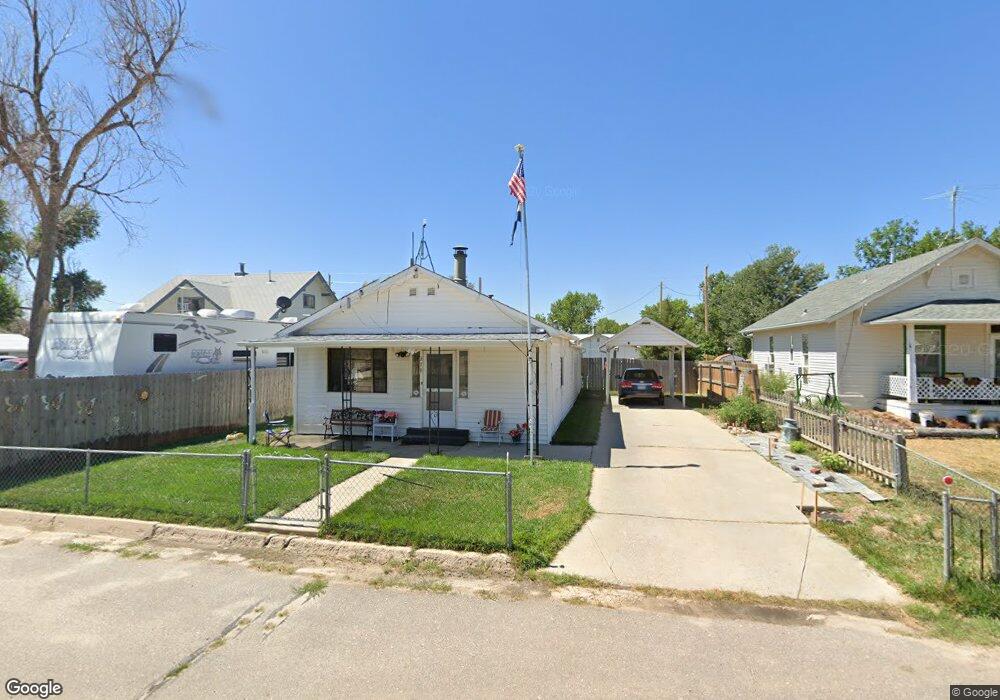
379 2nd Ave Deer Trail, CO 80105
Estimated Value: $259,000 - $312,000
2
Beds
1
Bath
1,126
Sq Ft
$257/Sq Ft
Est. Value
About This Home
This home is located at 379 2nd Ave, Deer Trail, CO 80105 and is currently estimated at $288,940, approximately $256 per square foot. 379 2nd Ave is a home with nearby schools including Deer Trail Elementary School and Deer Trail Junior/Senior High School.
Ownership History
Date
Name
Owned For
Owner Type
Purchase Details
Closed on
Jan 23, 1998
Sold by
Venter Lorraine C and Schaffer Ronald A
Bought by
Schaffer Ronald A and Schaffer Katherine Gayle
Current Estimated Value
Purchase Details
Closed on
Feb 20, 1991
Sold by
Wolf Bennie F Wolf Betty M
Bought by
Schaffer Ronald A Venter Lorraine C
Purchase Details
Closed on
Feb 14, 1991
Sold by
Conversion Arapco
Bought by
Wolf Bennie F Wolf Betty M
Purchase Details
Closed on
Apr 1, 1986
Sold by
Conversion Arapco
Bought by
Conversion Arapco
Purchase Details
Closed on
Jul 4, 1776
Bought by
Conversion Arapco
Create a Home Valuation Report for This Property
The Home Valuation Report is an in-depth analysis detailing your home's value as well as a comparison with similar homes in the area
Purchase History
| Date | Buyer | Sale Price | Title Company |
|---|---|---|---|
| Schaffer Ronald A | -- | -- | |
| Schaffer Ronald A Venter Lorraine C | -- | -- | |
| Wolf Bennie F Wolf Betty M | -- | -- | |
| Conversion Arapco | -- | -- | |
| Conversion Arapco | -- | -- |
Source: Public Records
Tax History
| Year | Tax Paid | Tax Assessment Tax Assessment Total Assessment is a certain percentage of the fair market value that is determined by local assessors to be the total taxable value of land and additions on the property. | Land | Improvement |
|---|---|---|---|---|
| 2025 | $1,367 | $17,169 | -- | -- |
| 2024 | $1,367 | $17,052 | -- | -- |
| 2023 | $1,282 | $17,052 | $0 | $0 |
| 2022 | $1,003 | $13,420 | $0 | $0 |
| 2021 | $1,051 | $13,420 | $0 | $0 |
| 2020 | $982 | $12,441 | $0 | $0 |
| 2019 | $968 | $12,441 | $0 | $0 |
| 2018 | $781 | $9,288 | $0 | $0 |
| 2017 | $781 | $9,288 | $0 | $0 |
| 2016 | $419 | $5,891 | $0 | $0 |
| 2015 | $410 | $5,891 | $0 | $0 |
| 2014 | -- | $6,487 | $0 | $0 |
| 2013 | -- | $6,040 | $0 | $0 |
Source: Public Records
Map
Nearby Homes
- 444 3rd Ave
- 492 3rd Ave
- 805 Cedar St
- 691 3rd Ave
- 1434 4th Ct
- 0 7th Ave
- 54 S 4th Place
- 84 S 4th Ave
- 192 S 4th Ave
- 265 S 4th Ct
- Vacant land 7 11th Ave
- Vacant Land 5 11th Ave
- 0 Vacant Land 6 Unit 6 REC6098118
- 306 S 4th Ct
- 310 S 4th Ct
- 0 Date St Unit REC7529128
- 436 S 3rd Ave
- 217 S Price Rd
- 4055 S Co Road 193
- 4295 S County Road 193
Your Personal Tour Guide
Ask me questions while you tour the home.