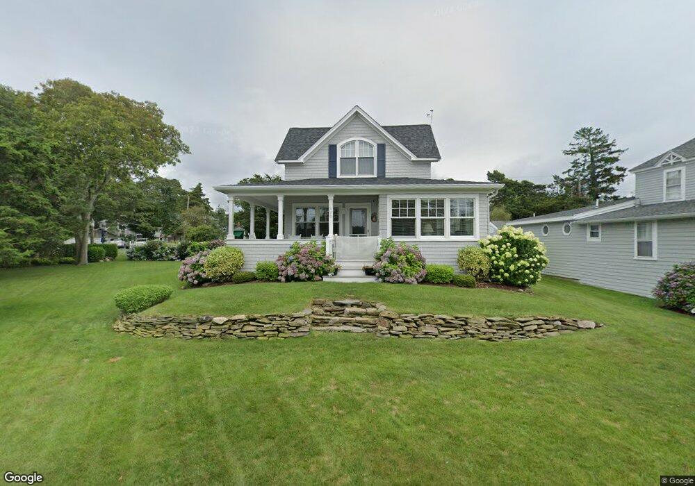
379 Circuit Ave Pocasset, MA 02559
Estimated Value: $948,000 - $2,177,000
4
Beds
2
Baths
1,839
Sq Ft
$735/Sq Ft
Est. Value
About This Home
This home is located at 379 Circuit Ave, Pocasset, MA 02559 and is currently estimated at $1,351,939, approximately $735 per square foot. 379 Circuit Ave is a home located in Barnstable County with nearby schools including Bourne High School and Cadence Academy Preschool - Bourne.
Ownership History
Date
Name
Owned For
Owner Type
Purchase Details
Closed on
May 28, 2008
Sold by
Dickson John H and Dickson Nancy C
Bought by
Dickson Nancy C
Current Estimated Value
Purchase Details
Closed on
May 27, 2008
Sold by
Dickson John H and Dickson Nancy C
Bought by
Dickson Nancy C
Purchase Details
Closed on
Jan 9, 2004
Sold by
White Edith Alice
Bought by
Dickson John H and Dickson Nancy C
Home Financials for this Owner
Home Financials are based on the most recent Mortgage that was taken out on this home.
Original Mortgage
$322,700
Interest Rate
5.88%
Mortgage Type
Purchase Money Mortgage
Create a Home Valuation Report for This Property
The Home Valuation Report is an in-depth analysis detailing your home's value as well as a comparison with similar homes in the area
Home Values in the Area
Average Home Value in this Area
Purchase History
| Date | Buyer | Sale Price | Title Company |
|---|---|---|---|
| Dickson Nancy C | -- | -- | |
| Dickson Nancy C | -- | -- | |
| Dickson Nancy C | -- | -- | |
| Dickson Nancy C | -- | -- | |
| Dickson John H | $1,050,000 | -- | |
| Dickson John H | $1,050,000 | -- |
Source: Public Records
Mortgage History
| Date | Status | Borrower | Loan Amount |
|---|---|---|---|
| Previous Owner | Dickson John H | $322,700 | |
| Previous Owner | Dickson John H | $99,000 | |
| Previous Owner | Dickson John H | $104,750 |
Source: Public Records
Tax History Compared to Growth
Tax History
| Year | Tax Paid | Tax Assessment Tax Assessment Total Assessment is a certain percentage of the fair market value that is determined by local assessors to be the total taxable value of land and additions on the property. | Land | Improvement |
|---|---|---|---|---|
| 2025 | $8,541 | $1,093,600 | $725,800 | $367,800 |
| 2024 | $8,351 | $1,041,300 | $691,100 | $350,200 |
| 2023 | $8,795 | $998,300 | $688,100 | $310,200 |
| 2022 | $9,181 | $909,900 | $663,100 | $246,800 |
| 2021 | $9,155 | $850,000 | $603,500 | $246,500 |
| 2020 | $9,070 | $844,500 | $597,700 | $246,800 |
| 2019 | $8,732 | $830,800 | $597,700 | $233,100 |
| 2018 | $8,342 | $791,500 | $569,300 | $222,200 |
| 2017 | $7,924 | $769,300 | $564,000 | $205,300 |
| 2016 | $7,767 | $764,500 | $564,000 | $200,500 |
| 2015 | $7,699 | $764,500 | $564,000 | $200,500 |
Source: Public Records
Map
Nearby Homes
- 51 Penobscot Ave
- 51 Penobscot Ave
- 9 Penobscot Ave
- 9 Penobscot Ave
- 22 Island Dr
- 89 Harbor Dr
- 41 Kenwood Rd
- 34 Kenwood Rd
- 45 Kenwood Rd
- 7 Spruce Dr
- 22 Nairn Rd
- 70 North Rd
- 70 Wings Neck Rd
- 24 Richmond Rd
- 1090 Shore Rd Unit 4
- 48 Red Brook Harbor Rd
- 3 Red Brook Pond Dr
- 1094 County Rd
- 10 Squeteague Harbor Rd