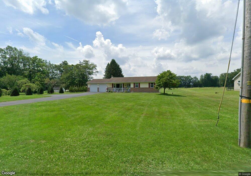
379 Mill Rd Lehighton, PA 18235
Estimated Value: $268,881 - $336,000
3
Beds
2
Baths
1,392
Sq Ft
$222/Sq Ft
Est. Value
About This Home
This home is located at 379 Mill Rd, Lehighton, PA 18235 and is currently estimated at $308,720, approximately $221 per square foot. 379 Mill Rd is a home located in Carbon County with nearby schools including Lehighton Area High School.
Ownership History
Date
Name
Owned For
Owner Type
Purchase Details
Closed on
Jan 11, 2016
Sold by
Galonsky Deborah A and Miller Jeffrey B
Bought by
Klotz Martin P and Klotz Linda K
Current Estimated Value
Home Financials for this Owner
Home Financials are based on the most recent Mortgage that was taken out on this home.
Original Mortgage
$135,000
Outstanding Balance
$107,368
Interest Rate
3.96%
Mortgage Type
New Conventional
Estimated Equity
$201,352
Purchase Details
Closed on
Oct 29, 2010
Sold by
Miller Burton R
Bought by
Miller Jeffrey B and Galonsky Deborah A
Create a Home Valuation Report for This Property
The Home Valuation Report is an in-depth analysis detailing your home's value as well as a comparison with similar homes in the area
Home Values in the Area
Average Home Value in this Area
Purchase History
| Date | Buyer | Sale Price | Title Company |
|---|---|---|---|
| Klotz Martin P | $150,000 | Attorney | |
| Miller Jeffrey B | -- | None Available |
Source: Public Records
Mortgage History
| Date | Status | Borrower | Loan Amount |
|---|---|---|---|
| Open | Klotz Martin P | $135,000 |
Source: Public Records
Tax History Compared to Growth
Tax History
| Year | Tax Paid | Tax Assessment Tax Assessment Total Assessment is a certain percentage of the fair market value that is determined by local assessors to be the total taxable value of land and additions on the property. | Land | Improvement |
|---|---|---|---|---|
| 2025 | $4,105 | $53,650 | $9,750 | $43,900 |
| 2024 | $3,944 | $53,650 | $9,750 | $43,900 |
| 2023 | $3,904 | $53,650 | $9,750 | $43,900 |
| 2022 | $3,850 | $53,650 | $9,750 | $43,900 |
| 2021 | $3,736 | $53,650 | $9,750 | $43,900 |
| 2020 | $3,642 | $53,650 | $9,750 | $43,900 |
| 2019 | $3,454 | $53,650 | $9,750 | $43,900 |
| 2018 | $3,414 | $53,650 | $9,750 | $43,900 |
| 2017 | $3,414 | $53,650 | $9,750 | $43,900 |
| 2016 | -- | $53,650 | $9,750 | $43,900 |
| 2015 | -- | $53,650 | $9,750 | $43,900 |
| 2014 | -- | $53,650 | $9,750 | $43,900 |
Source: Public Records
Map
Nearby Homes
- 265 Mill Rd
- 1772 Mahoning Dr W
- 0 Beacon Pointe Plan at Summit Ridge
- 0 Blue Ridge Plan at Summit Ridge Unit PACC2005476
- 0 Georgia Mae Plan at Summit Ridge Unit PACC2005482
- Abbey Plan at Summit Ridge
- Beacon Pointe Plan at Summit Ridge
- White Oak Plan at Summit Ridge
- Black Cherry Plan at Summit Ridge
- Blue Ridge Plan at Summit Ridge
- Copper Beech Plan at Summit Ridge
- Sweet Birch Plan at Summit Ridge
- Georgia Mae Plan at Summit Ridge
- Emily Plan at Summit Ridge
- 134 Huron Dr
- 437 Chapel Dr
- 0 Abbey Plan at Summit Ridge Unit PACC2005470
- 0 Huron Ct Unit Lot 06
- TBD Heron Ct
- 93 Heartwood Ct