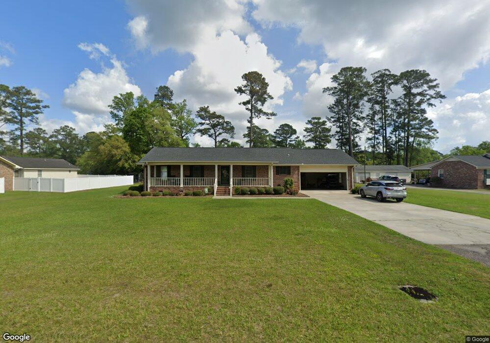
379 Walnut Ave Georgetown, SC 29440
Estimated Value: $285,000 - $369,000
3
Beds
2
Baths
1,736
Sq Ft
$186/Sq Ft
Est. Value
About This Home
This home is located at 379 Walnut Ave, Georgetown, SC 29440 and is currently estimated at $322,526, approximately $185 per square foot. 379 Walnut Ave is a home located in Georgetown County with nearby schools including Kensington Elementary School, Georgetown Middle School, and Georgetown High School.
Ownership History
Date
Name
Owned For
Owner Type
Purchase Details
Closed on
Oct 9, 2019
Sold by
Moore Lindsey R and Williams James F
Bought by
Moore Lindsey R
Current Estimated Value
Purchase Details
Closed on
Aug 24, 2016
Sold by
Loadholt Judith
Bought by
Moore Lindsey R and Williams James F
Home Financials for this Owner
Home Financials are based on the most recent Mortgage that was taken out on this home.
Original Mortgage
$204,250
Interest Rate
3.48%
Mortgage Type
New Conventional
Create a Home Valuation Report for This Property
The Home Valuation Report is an in-depth analysis detailing your home's value as well as a comparison with similar homes in the area
Purchase History
| Date | Buyer | Sale Price | Title Company |
|---|---|---|---|
| Moore Lindsey R | $20,000 | None Available | |
| Moore Lindsey R | $180,000 | -- |
Source: Public Records
Mortgage History
| Date | Status | Borrower | Loan Amount |
|---|---|---|---|
| Previous Owner | Moore Lindsey R | $204,250 |
Source: Public Records
Tax History
| Year | Tax Paid | Tax Assessment Tax Assessment Total Assessment is a certain percentage of the fair market value that is determined by local assessors to be the total taxable value of land and additions on the property. | Land | Improvement |
|---|---|---|---|---|
| 2025 | $1,238 | $8,574 | $1,414 | $7,160 |
| 2024 | $1,238 | $7,450 | $1,050 | $6,400 |
| 2023 | $1,172 | $7,450 | $1,050 | $6,400 |
| 2022 | $1,085 | $7,450 | $1,050 | $6,400 |
| 2021 | $1,057 | $7,456 | $1,052 | $6,404 |
| 2020 | $1,055 | $7,456 | $1,052 | $6,404 |
| 2019 | $1,012 | $7,164 | $1,052 | $6,112 |
| 2018 | $1,034 | $71,640 | $0 | $0 |
| 2017 | $2,451 | $71,640 | $0 | $0 |
| 2016 | $737 | $8,168 | $0 | $0 |
| 2015 | $977 | $0 | $0 | $0 |
| 2014 | $977 | $197,700 | $26,300 | $171,400 |
| 2012 | -- | $197,700 | $26,300 | $171,400 |
Source: Public Records
Map
Nearby Homes
- 1824 Sumter St
- 2347 Devine St
- 2516 N Fraser St Unit 12.26 acres
- 465 Summit Ave Unit Lot 13 - Abaco
- 814 2nd Ave Unit Colonial Estates
- 1841 Jasper St
- 1738 Jasper St
- Lot 3 3rd Ave
- TBD Weehaw Plantation Dr Unit 65 Acres
- 380 Rose Ave
- 459 Garden Ave
- 607 Garden Ave
- 621 Garden Ave
- 0 Rainey Dr
- TBD U S 701 Hwy
- 2478 N Fraser St Unit 12+ acres
- 902 Palm St
- 815 N Congdon St
- 0 Legion St
- 615 Palm St
- 407 Walnut Ave
- 359 Walnut Ave
- 414 Lakewood Ave Unit Kensington Estates
- 414 Lakewood Ave
- 378 Lakewood Ave
- 435 Walnut Ave
- 359 Forest Ave
- 425 Forest Ave
- 454 Lakewood Ave
- 356 Lakewood Ave
- 369 Lakewood Ave
- 435 Lakewood Ave
- 463 Walnut Ave
- 455 Forest Ave
- 296 Walnut Ave
- 321 Forest Ave
- 361 Lakewood Ave
- 334 Lakewood Ave
- 2287 Brook St
- 494 Lakewood Ave
Your Personal Tour Guide
Ask me questions while you tour the home.