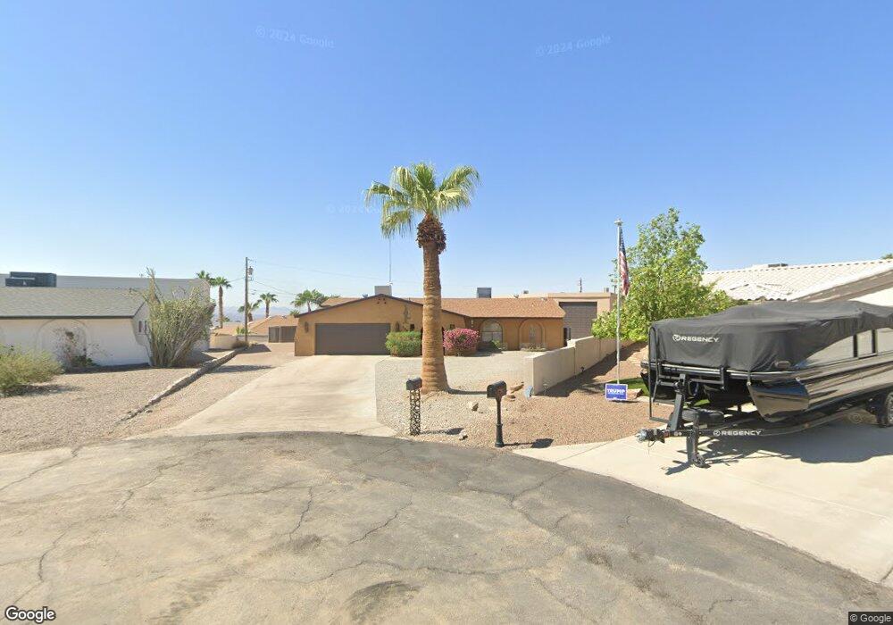
3799 Solar Cir Lake Havasu City, AZ 86406
Estimated Value: $466,981 - $739,000
3
Beds
2
Baths
1,435
Sq Ft
$388/Sq Ft
Est. Value
About This Home
This home is located at 3799 Solar Cir, Lake Havasu City, AZ 86406 and is currently estimated at $556,745, approximately $387 per square foot. 3799 Solar Cir is a home located in Mohave County with nearby schools including Jamaica Elementary School, Thunderbolt Middle School, and Lake Havasu High School.
Ownership History
Date
Name
Owned For
Owner Type
Purchase Details
Closed on
Sep 7, 2023
Sold by
Finch William B and Finch Tammy L
Bought by
Finch Family Trust and Finch
Current Estimated Value
Purchase Details
Closed on
Nov 6, 2008
Sold by
Deutsche Bank National Trust Company
Bought by
Finch William B and Finch Tammy L
Home Financials for this Owner
Home Financials are based on the most recent Mortgage that was taken out on this home.
Original Mortgage
$81,000
Interest Rate
6.37%
Mortgage Type
New Conventional
Purchase Details
Closed on
Mar 28, 2008
Sold by
Matus David G
Bought by
Deutsche Bank National Trust Co
Purchase Details
Closed on
Jul 26, 2002
Sold by
Matus Teresa K
Bought by
Matus David G
Purchase Details
Closed on
Jun 20, 2002
Sold by
Mathis Gladys M
Bought by
Matus David G
Create a Home Valuation Report for This Property
The Home Valuation Report is an in-depth analysis detailing your home's value as well as a comparison with similar homes in the area
Home Values in the Area
Average Home Value in this Area
Purchase History
| Date | Buyer | Sale Price | Title Company |
|---|---|---|---|
| Finch Family Trust | -- | None Listed On Document | |
| Finch William B | $90,000 | Dhi Title Of Arizona Inc | |
| Deutsche Bank National Trust Co | $110,810 | First American Title Insuran | |
| Matus David G | -- | Transnation Title Insurance | |
| Matus David G | $112,900 | Transnation Title Insurance |
Source: Public Records
Mortgage History
| Date | Status | Borrower | Loan Amount |
|---|---|---|---|
| Previous Owner | Finch William B | $81,000 |
Source: Public Records
Tax History Compared to Growth
Tax History
| Year | Tax Paid | Tax Assessment Tax Assessment Total Assessment is a certain percentage of the fair market value that is determined by local assessors to be the total taxable value of land and additions on the property. | Land | Improvement |
|---|---|---|---|---|
| 2026 | -- | -- | -- | -- |
| 2025 | $1,863 | $52,325 | $0 | $0 |
| 2024 | $1,863 | $47,292 | $0 | $0 |
| 2023 | $1,863 | $27,411 | $0 | $0 |
| 2022 | $965 | $18,329 | $0 | $0 |
| 2021 | $1,142 | $18,559 | $0 | $0 |
| 2019 | $1,088 | $14,695 | $0 | $0 |
| 2018 | $1,053 | $13,920 | $0 | $0 |
| 2017 | $1,036 | $13,204 | $0 | $0 |
| 2016 | $923 | $12,029 | $0 | $0 |
| 2015 | $900 | $10,581 | $0 | $0 |
Source: Public Records
Map
Nearby Homes
- 3852 Solar Dr
- 3856 Mission Dr N
- 3828 Cherry Tree Blvd
- 3751 Mission Dr S
- 3812 Yonder Dr
- 250 Geronimo Blvd
- 3937 Comet Dr
- 3883 Sloop Dr
- 3956 Cherry Tree Blvd
- 3873 Packard Place
- 3665 Pelican Place
- 3776 Hiawatha Dr
- 3780 Hiawatha Dr
- 3565 El Rey Ln
- 4014 Cherry Tree Blvd
- 4019 Black Hill Dr
- 3504 Pioneer Dr
- 4050 Cherry Tree Blvd
- 3808 Whaler Dr
- 4051 Northstar Dr