
Seller's Agent in 2025
Kimberly Gates
Gateway Real Estate
(860) 944-8733
4 in this area
127 Total Sales
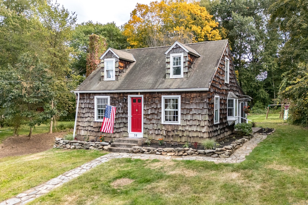
Charming & Quaint New England 3 BR Cape Cod at end of Cul-de-Sac is steps away from Hop River Rail Trail and easy access to routes for commuting to Hartford or any surrounding areas * Open Kitchen & Dining Area is Bright and Inviting * Living Room has Fireplace & Hardwood Floors * 1st Floor BR has ceiling fan & hardwood floors * Enclosed Sunroom overlooks a Spacious, Level Backyard, perfect for entertaining, playing, gardening, etc! * Upstairs BRs have newer flooring and built-ins (wood planks under flooring)* Walk-ouit Basement provides storage and can also be easily finished * Updates include New Heating system, New Well Pressue Tank, Flooring, Paint, Landscaping, light fixtures
Last Agent to Sell the Property
Gateway Real Estate Brokerage Phone: (860) 944-8733 License #REB.0794558 Listed on: 09/17/2025
| Date | Type | Sale Price | Title Company |
|---|---|---|---|
| Executors Deed | $138,000 | -- | |
| Executors Deed | $138,000 | -- | |
| Deed | -- | -- |
| Date | Status | Loan Amount | Loan Type |
|---|---|---|---|
| Open | $135,500 | Unknown |
| Date | Event | Price | List to Sale | Price per Sq Ft |
|---|---|---|---|---|
| 11/13/2025 11/13/25 | Sold | $290,000 | +1.8% | $288 / Sq Ft |
| 11/13/2025 11/13/25 | Pending | -- | -- | -- |
| 10/05/2025 10/05/25 | Price Changed | $285,000 | -3.2% | $283 / Sq Ft |
| 09/17/2025 09/17/25 | For Sale | $294,500 | -- | $292 / Sq Ft |
| Year | Tax Paid | Tax Assessment Tax Assessment Total Assessment is a certain percentage of the fair market value that is determined by local assessors to be the total taxable value of land and additions on the property. | Land | Improvement |
|---|---|---|---|---|
| 2025 | $3,328 | $105,350 | $32,340 | $73,010 |
| 2024 | $3,314 | $105,350 | $32,340 | $73,010 |
| 2023 | $3,296 | $105,350 | $32,340 | $73,010 |
| 2022 | $3,362 | $105,350 | $32,340 | $73,010 |
| 2021 | $3,791 | $105,300 | $42,800 | $62,500 |
| 2020 | $3,750 | $105,300 | $42,800 | $62,500 |
| 2019 | $3,684 | $105,300 | $42,800 | $62,500 |
| 2018 | $3,575 | $105,300 | $42,800 | $62,500 |
| 2017 | $3,422 | $105,300 | $42,800 | $62,500 |
| 2016 | $3,223 | $104,900 | $42,800 | $62,100 |
| 2015 | $3,223 | $104,900 | $42,800 | $62,100 |
| 2014 | $3,223 | $104,900 | $42,800 | $62,100 |
Seller's Agent in 2025
Kimberly Gates
Gateway Real Estate
(860) 944-8733
4 in this area
127 Total Sales
Buyer's Agent in 2025
Sarah Bezdelovs
Berkshire Hathaway Home Services
(860) 816-3034
1 in this area
15 Total Sales
Source: SmartMLS
MLS Number: 24127297
APN: ANDO-000028-000005-000017
Disclaimer: Certain information contained herein is derived from information provided by parties other than Homes.com. All information provided is deemed reliable, but is not guaranteed to be accurate and should be independently verified.
![]() IDX information is provided exclusively for personal, non-commercial use, and may not be used for any purpose other than to identify prospective properties consumers may be interested in purchasing. Information is deemed reliable but not guaranteed.
IDX information is provided exclusively for personal, non-commercial use, and may not be used for any purpose other than to identify prospective properties consumers may be interested in purchasing. Information is deemed reliable but not guaranteed.