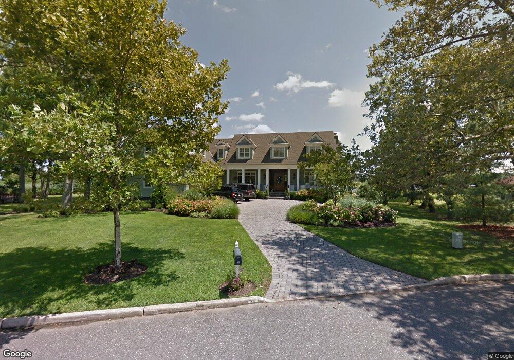
38 Breezy Point Rd Little Silver, NJ 07739
Estimated Value: $2,960,000 - $3,641,563
5
Beds
6
Baths
7,025
Sq Ft
$475/Sq Ft
Est. Value
About This Home
This home is located at 38 Breezy Point Rd, Little Silver, NJ 07739 and is currently estimated at $3,334,891, approximately $474 per square foot. 38 Breezy Point Rd is a home located in Monmouth County with nearby schools including Point Road School, Markham Place School, and Red Bank Regional High School.
Ownership History
Date
Name
Owned For
Owner Type
Purchase Details
Closed on
Mar 26, 2009
Sold by
Mcloone Elizabeth
Bought by
Mcloone Elizabeth and Mcloone Timothy
Current Estimated Value
Purchase Details
Closed on
Oct 4, 2000
Sold by
Schmelz Steven
Bought by
Mcloone Elizabeth
Home Financials for this Owner
Home Financials are based on the most recent Mortgage that was taken out on this home.
Original Mortgage
$528,750
Outstanding Balance
$192,278
Interest Rate
7.88%
Mortgage Type
Purchase Money Mortgage
Estimated Equity
$3,142,613
Purchase Details
Closed on
Aug 31, 1999
Sold by
Doyle Joyce
Bought by
Rosenstrach Dawn and Soviero Peter
Home Financials for this Owner
Home Financials are based on the most recent Mortgage that was taken out on this home.
Original Mortgage
$500,000
Interest Rate
7.85%
Mortgage Type
Purchase Money Mortgage
Create a Home Valuation Report for This Property
The Home Valuation Report is an in-depth analysis detailing your home's value as well as a comparison with similar homes in the area
Home Values in the Area
Average Home Value in this Area
Purchase History
| Date | Buyer | Sale Price | Title Company |
|---|---|---|---|
| Mcloone Elizabeth | -- | None Available | |
| Mcloone Elizabeth | $705,000 | -- | |
| Rosenstrach Dawn | $650,000 | -- |
Source: Public Records
Mortgage History
| Date | Status | Borrower | Loan Amount |
|---|---|---|---|
| Open | Mcloone Elizabeth | $528,750 | |
| Previous Owner | Rosenstrach Dawn | $500,000 |
Source: Public Records
Tax History Compared to Growth
Tax History
| Year | Tax Paid | Tax Assessment Tax Assessment Total Assessment is a certain percentage of the fair market value that is determined by local assessors to be the total taxable value of land and additions on the property. | Land | Improvement |
|---|---|---|---|---|
| 2025 | $39,400 | $3,081,400 | $1,091,900 | $1,989,500 |
| 2024 | $39,400 | $2,380,700 | $972,500 | $1,408,200 |
| 2023 | $39,400 | $2,188,900 | $803,700 | $1,385,200 |
| 2022 | $37,686 | $2,043,200 | $709,200 | $1,334,000 |
| 2021 | $37,686 | $1,909,100 | $709,200 | $1,199,900 |
| 2020 | $38,414 | $1,895,100 | $709,200 | $1,185,900 |
| 2019 | $38,093 | $1,914,200 | $709,200 | $1,205,000 |
| 2018 | $37,127 | $1,858,200 | $709,200 | $1,149,000 |
| 2017 | $36,851 | $1,835,200 | $709,200 | $1,126,000 |
| 2016 | $36,081 | $1,818,600 | $709,200 | $1,109,400 |
| 2015 | $35,829 | $1,783,400 | $691,200 | $1,092,200 |
| 2014 | $35,436 | $1,648,200 | $691,200 | $957,000 |
Source: Public Records
Map
Nearby Homes
- 3 Foggia Way
- 10 Asbury Ave
- 41 Edgewood Ave
- 66 Shrewsbury Ave
- 3 Sandbar Alley
- 212 Willow Dr
- 27 Ithaca Ave
- 16 Haskell Way
- 50 Willow Dr
- 35 Sunnybank Dr
- 8 Pocahontas Ave
- 33 Willow Dr
- 26 Prince Place
- 13 Morris Place
- 14 Oceanport Ave
- 15 Signal Ave
- 40 Brookside Ln
- 36 Maple Ave
- 55 Cheshire Square
- 580 Patten Ave Unit 47
- 32 Breezy Point Rd
- 42 Breezy Point Rd
- 26 Breezy Point Rd
- 33 Breezy Point Rd
- 41 Breezy Point Rd
- 27 Breezy Point Rd
- 18 Breezy Point Rd
- 21 Breezy Point Rd
- 12 Silverside Ave
- 35 Alwin Terrace
- 10 Breezy Point Rd
- 31 Alwin Terrace
- 39 Alwin Terrace
- 13 Breezy Point Rd
- 25 Alwin Terrace
- 19 Alwin Terrace
- 9 Breezy Point Rd
- 2 Silverside Ave
- 4 Breezy Point Rd
- 15 Alwin Terrace