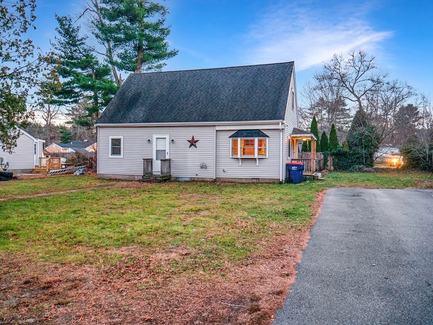


38 Cedar Dr Carver, MA 02330
Estimated payment $2,805/month
Highlights
- Cape Cod Architecture
- Wood Flooring
- Porch
- Wooded Lot
- No HOA
- Outdoor Storage
About This Home
Great starter home in a quiet neighborhood near Crystal Lake. This 3 bedroom, 1 bath Single Family home sits on a level lot with bedrooms on both levels, a bonus room ideal for an office, playroom or guest space, and a full basement for storage or future finishing. Cosmetic updates are optional for buyers who want to add their own style. Private well with water softener and a newer septic system in place (Title V inspection scheduled 12/12/25). A great fit for a first time homebuyer or anyone looking for an affordable single family to grow into. Vacant, easy to show and potentially a quick closing. Estate sale.
Home Details
Home Type
- Single Family
Est. Annual Taxes
- $5,085
Year Built
- Built in 1954
Lot Details
- 8,276 Sq Ft Lot
- Wooded Lot
- Property is zoned RA
Parking
- 2 Open Parking Spaces
Home Design
- 1,332 Sq Ft Home
- Cape Cod Architecture
- Frame Construction
- Asphalt Roof
- Concrete Perimeter Foundation
Kitchen
- Oven
- Range
- Microwave
- ENERGY STAR Qualified Refrigerator
Flooring
- Wood
- Carpet
Bedrooms and Bathrooms
- 3 Bedrooms
- 1 Full Bathroom
Laundry
- Washer and Electric Dryer Hookup
Unfinished Basement
- Interior Basement Entry
- Block Basement Construction
Outdoor Features
- Outdoor Storage
- Porch
Utilities
- No Cooling
- Heating System Uses Oil
- Baseboard Heating
- Private Water Source
- Water Heater
- Private Sewer
- Satellite Dish
Community Details
- No Home Owners Association
Listing and Financial Details
- Assessor Parcel Number M:62 P:115,991357
Map
Home Values in the Area
Average Home Value in this Area
Tax History
| Year | Tax Paid | Tax Assessment Tax Assessment Total Assessment is a certain percentage of the fair market value that is determined by local assessors to be the total taxable value of land and additions on the property. | Land | Improvement |
|---|---|---|---|---|
| 2025 | $5,085 | $366,600 | $121,500 | $245,100 |
| 2024 | $4,775 | $337,000 | $119,200 | $217,800 |
| 2023 | $4,663 | $319,600 | $119,200 | $200,400 |
| 2022 | $4,398 | $275,200 | $101,900 | $173,300 |
| 2021 | $4,189 | $247,300 | $91,000 | $156,300 |
| 2020 | $4,022 | $234,000 | $85,000 | $149,000 |
| 2019 | $3,881 | $227,600 | $82,500 | $145,100 |
| 2018 | $3,655 | $207,300 | $82,500 | $124,800 |
| 2017 | $4,562 | $199,500 | $79,400 | $120,100 |
| 2016 | $3,311 | $194,400 | $79,400 | $115,000 |
| 2015 | $3,225 | $189,600 | $79,400 | $110,200 |
| 2014 | $3,206 | $188,500 | $95,600 | $92,900 |
Property History
| Date | Event | Price | List to Sale | Price per Sq Ft |
|---|---|---|---|---|
| 12/30/2025 12/30/25 | Pending | -- | -- | -- |
| 12/27/2025 12/27/25 | For Sale | $459,900 | 0.0% | $345 / Sq Ft |
| 12/10/2025 12/10/25 | Pending | -- | -- | -- |
| 12/08/2025 12/08/25 | For Sale | $459,900 | -- | $345 / Sq Ft |
Purchase History
| Date | Type | Sale Price | Title Company |
|---|---|---|---|
| Quit Claim Deed | -- | -- | |
| Deed | $210,000 | -- | |
| Deed | $92,000 | -- |
Mortgage History
| Date | Status | Loan Amount | Loan Type |
|---|---|---|---|
| Previous Owner | $217,600 | No Value Available | |
| Previous Owner | $168,000 | Purchase Money Mortgage | |
| Previous Owner | $91,250 | No Value Available | |
| Previous Owner | $91,800 | Purchase Money Mortgage |
Source: MLS Property Information Network (MLS PIN)
MLS Number: 73460568
APN: CARV-000062-000000-000115
Disclaimer: Certain information contained herein is derived from information provided by parties other than Homes.com. All information provided is deemed reliable, but is not guaranteed to be accurate and should be independently verified.
![]() The property listing data and information, or the Images, set forth herein were provided to MLS Property Information Network, Inc. from third party sources, including sellers, lessors and public records, and were compiled by MLS Property Information Network, Inc. The property listing data and information, and the Images, are for the personal, non-commercial use of consumers having a good faith interest in purchasing or leasing listed properties of the type displayed to them and may not be used for any purpose other than to identify prospective properties which such consumers may have a good faith interest in purchasing or leasing. MLS Property Information Network, Inc. and its subscribers disclaim any and all representations and warranties as to the accuracy of the property listing data and information, or as to the accuracy of any of the Images, set forth herein.
The property listing data and information, or the Images, set forth herein were provided to MLS Property Information Network, Inc. from third party sources, including sellers, lessors and public records, and were compiled by MLS Property Information Network, Inc. The property listing data and information, and the Images, are for the personal, non-commercial use of consumers having a good faith interest in purchasing or leasing listed properties of the type displayed to them and may not be used for any purpose other than to identify prospective properties which such consumers may have a good faith interest in purchasing or leasing. MLS Property Information Network, Inc. and its subscribers disclaim any and all representations and warranties as to the accuracy of the property listing data and information, or as to the accuracy of any of the Images, set forth herein.
- 32 Doreen Way
- 235 Main St
- 35 Silva St
- 81 Center St
- 269 Purchase St
- 48 S Meadow Village
- 29 S Meadow Village
- 22 S Meadow Village
- 11 Brockton Ave
- 7 Green St
- 26 Santana Way Unit 26
- 135 Plymouth St
- 146 S Meadow Rd
- 28 S Main St
- Lot1 Elk Run Dr
- 13 Pond View Way
- 56 Bunnys Rd
- Lot 1 Ohana Way
- Lot 2 Ohana Way
- 6 Susan Cir
