Estimated Value: $216,349 - $279,000
--
Bed
--
Bath
1,563
Sq Ft
$163/Sq Ft
Est. Value
About This Home
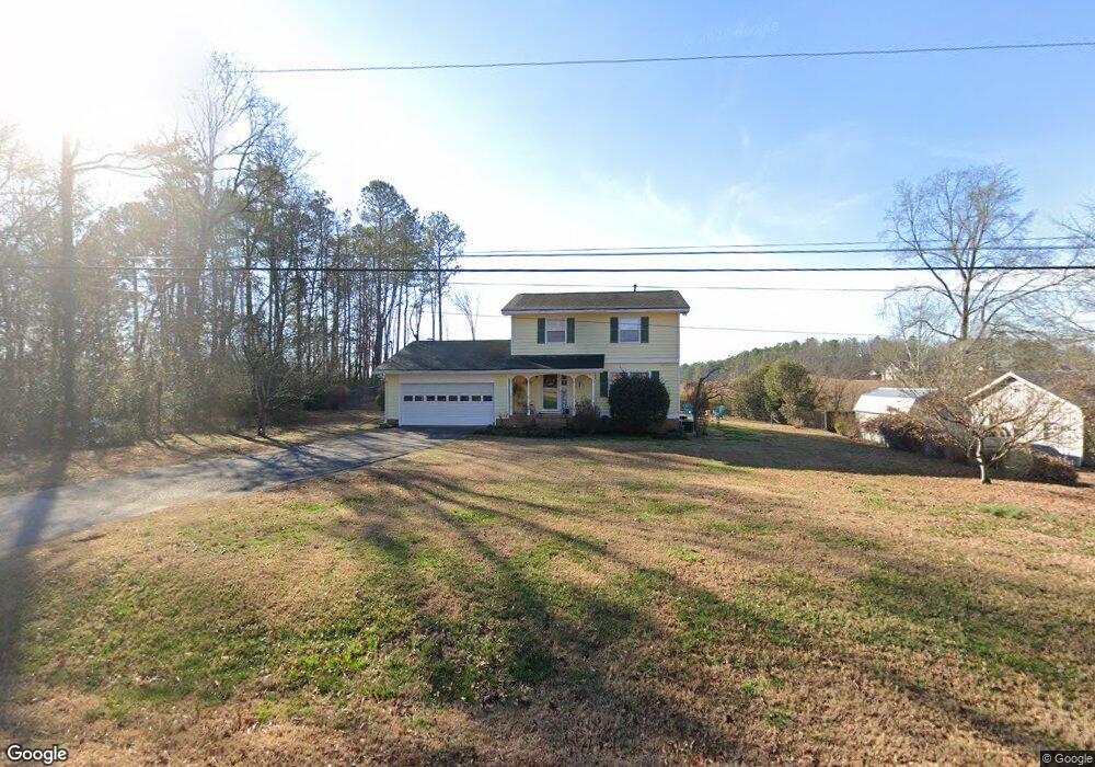
This home is located at 38 Ford Rd SE, Rome, GA 30161 and is currently estimated at $254,087, approximately $162 per square foot. 38 Ford Rd SE is a home located in Floyd County with nearby schools including Model Middle School, Model High School, and Unity Christian School.
Ownership History
Date
Name
Owned For
Owner Type
Purchase Details
Closed on
Aug 11, 1993
Sold by
Minshew Steve and Minshew Karen C
Bought by
Payne Scott and Payne Susan D
Current Estimated Value
Purchase Details
Closed on
Mar 11, 1980
Sold by
Rhodes Charles D and Rhodes Evelyn E
Bought by
Minshew Steve and Minshew Karen C
Purchase Details
Closed on
Jan 26, 1979
Sold by
Equitable Life Assurance Soc Of Us
Bought by
Rhodes Charles D and Rhodes Evelyn E
Purchase Details
Closed on
Jun 29, 1978
Sold by
Black Thomas M
Bought by
Equitable Life Assurance Soc Of Us
Purchase Details
Closed on
Nov 25, 1975
Bought by
P and R
Purchase Details
Closed on
Oct 20, 1975
Sold by
Blankenship Henry E
Bought by
Black Thomas M
Purchase Details
Closed on
Jun 12, 1975
Sold by
Munchak Theodore J
Bought by
Blankenship Henry E
Purchase Details
Closed on
Mar 17, 1970
Bought by
Munchak Theodore J
Create a Home Valuation Report for This Property
The Home Valuation Report is an in-depth analysis detailing your home's value as well as a comparison with similar homes in the area
Home Values in the Area
Average Home Value in this Area
Purchase History
| Date | Buyer | Sale Price | Title Company |
|---|---|---|---|
| Payne Scott | $74,500 | -- | |
| Minshew Steve | $48,500 | -- | |
| Rhodes Charles D | -- | -- | |
| Equitable Life Assurance Soc Of Us | $39,800 | -- | |
| P | -- | -- | |
| Black Thomas M | $39,000 | -- | |
| Blankenship Henry E | $38,500 | -- | |
| Munchak Theodore J | -- | -- |
Source: Public Records
Tax History Compared to Growth
Tax History
| Year | Tax Paid | Tax Assessment Tax Assessment Total Assessment is a certain percentage of the fair market value that is determined by local assessors to be the total taxable value of land and additions on the property. | Land | Improvement |
|---|---|---|---|---|
| 2024 | $1,638 | $73,939 | $14,572 | $59,367 |
| 2023 | $1,620 | $71,095 | $12,953 | $58,142 |
| 2022 | $1,453 | $59,335 | $10,794 | $48,541 |
| 2021 | $1,406 | $55,461 | $10,794 | $44,667 |
| 2020 | $1,338 | $51,181 | $8,096 | $43,085 |
| 2019 | $1,292 | $49,450 | $8,096 | $41,354 |
| 2018 | $1,262 | $47,660 | $8,096 | $39,564 |
| 2017 | $1,254 | $47,092 | $8,096 | $38,996 |
| 2016 | $1,263 | $46,720 | $8,080 | $38,640 |
| 2015 | $1,222 | $45,767 | $8,080 | $37,687 |
| 2014 | $1,222 | $45,767 | $8,080 | $37,687 |
Source: Public Records
Map
Nearby Homes
- 38 Busby Dr SE
- 36 Busby Dr SE
- 0 Old Freeman Ferry Rd SE Unit 10611047
- 13 Breckenridge Rd SE
- 11 Breckenridge Rd SE
- 230 Old Freeman Ferry Rd SE
- 4 Covey Rise Dr SE
- 14 Laurchris Dr SE
- 9 Heather Rd SE
- 100 Valley Brook Dr SE
- 4 Bridgeview Dr SE
- 0 Moran Lake Rd NE Unit 10592848
- 0 Moran Lake Rd NE Unit 7639960
- 0 Moran Lake Rd NE Unit 229 10584708
- 8 Covey Rise Dr SE
- 12 Covey Rise Dr SE
- 120 Keown Rd SE
- 22 Robin Hood Rd NE
- 113 Etowah Dr SE
- 6 Friar Tuck Rd NE
- 36 Ford Rd SE
- 0 Wildflower Rd NE
- 0 Wildflower Rd NE Unit 10341951
- 0 Wildflower Rd NE Unit 7423952
- 0 Wildflower Rd NE Unit 7153645
- 0 Wildflower Rd NE Unit 7622248
- 0 Wildflower Rd NE Unit 8072612
- 0 Wildflower Rd NE Unit 8926692
- 0 Wildflower Rd NE Unit 3258887
- 0 Wildflower Rd NE Unit 7105051
- 0 Wildflower Rd NE Unit 7119686
- 0 Wildflower Rd NE Unit 7150381
- 0 Wildflower Rd NE Unit 8192902
- 0 Wildflower Rd NE Unit 8225429
- 0 Wildflower Rd NE Unit 8444299
- 0 Wildflower Rd NE Unit 8558643
- 40 Ford Rd SE
- 17 Heights Dr SE
- 34 Ford Rd SE
- 37 Ford Rd SE