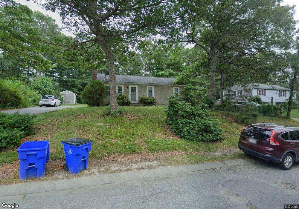
38 Howard Ave Bourne, MA 2532
Monument Beach NeighborhoodEstimated Value: $399,000 - $557,000
3
Beds
1
Bath
960
Sq Ft
$500/Sq Ft
Est. Value
About This Home
This home is located at 38 Howard Ave, Bourne, MA 2532 and is currently estimated at $480,155, approximately $500 per square foot. 38 Howard Ave is a home located in Barnstable County with nearby schools including Bourne High School, Cadence Academy Preschool - Bourne, and St Margaret Regional School.
Ownership History
Date
Name
Owned For
Owner Type
Purchase Details
Closed on
May 25, 1994
Sold by
Halle Rene C
Bought by
Deveer Joseph M and Deveer Charlene R
Current Estimated Value
Home Financials for this Owner
Home Financials are based on the most recent Mortgage that was taken out on this home.
Original Mortgage
$103,180
Interest Rate
8.22%
Mortgage Type
Purchase Money Mortgage
Purchase Details
Closed on
May 8, 1992
Sold by
Halle Rene Conrad and Halle Lorraine A
Bought by
Halle Rene C
Home Financials for this Owner
Home Financials are based on the most recent Mortgage that was taken out on this home.
Original Mortgage
$75,000
Interest Rate
8.91%
Mortgage Type
Purchase Money Mortgage
Create a Home Valuation Report for This Property
The Home Valuation Report is an in-depth analysis detailing your home's value as well as a comparison with similar homes in the area
Home Values in the Area
Average Home Value in this Area
Purchase History
| Date | Buyer | Sale Price | Title Company |
|---|---|---|---|
| Deveer Joseph M | $102,900 | -- | |
| Deveer Joseph M | $102,900 | -- | |
| Halle Rene C | $43,000 | -- | |
| Halle Rene C | $43,000 | -- |
Source: Public Records
Mortgage History
| Date | Status | Borrower | Loan Amount |
|---|---|---|---|
| Open | Halle Rene C | $110,500 | |
| Closed | Halle Rene C | $103,180 | |
| Previous Owner | Halle Rene C | $75,000 |
Source: Public Records
Tax History
| Year | Tax Paid | Tax Assessment Tax Assessment Total Assessment is a certain percentage of the fair market value that is determined by local assessors to be the total taxable value of land and additions on the property. | Land | Improvement |
|---|---|---|---|---|
| 2025 | $2,969 | $380,100 | $192,000 | $188,100 |
| 2024 | $2,903 | $362,000 | $182,900 | $179,100 |
| 2023 | $2,823 | $320,400 | $161,900 | $158,500 |
| 2022 | $2,730 | $270,600 | $143,200 | $127,400 |
| 2021 | $2,654 | $246,400 | $130,400 | $116,000 |
| 2020 | $2,567 | $239,000 | $129,100 | $109,900 |
| 2019 | $2,447 | $232,800 | $129,100 | $103,700 |
| 2018 | $2,222 | $210,800 | $117,100 | $93,700 |
| 2017 | $2,028 | $196,900 | $116,000 | $80,900 |
| 2016 | $1,984 | $195,300 | $116,000 | $79,300 |
| 2015 | $1,967 | $195,300 | $116,000 | $79,300 |
Source: Public Records
Map
Nearby Homes
- 10 Howard Ave
- 10 Howard Ave
- 20 Colony Ave
- 5 Harbor Hill Dr
- 4 Harbor Hill Dr
- 566 Shore Rd
- 16 Amberwood Ct
- 203 County Rd
- 12 Turnberry Rd Unit 12
- 4 Hollyhock Knoll Ct Unit 4
- 4 Hollyhock Knoll Ct Unit 4
- 2 Applewood Ct
- 13 Laurel Hill Ct
- 3 1st St
- 5 Sea Knoll Ct
- 709 County Rd
- 3 4th Ave
- 7 4th Ave
- 14 Navajo Rd
- 254 Barlows Landing Rd
Your Personal Tour Guide
Ask me questions while you tour the home.