Estimated Value: $241,000 - $279,000
3
Beds
2
Baths
1,758
Sq Ft
$148/Sq Ft
Est. Value
About This Home
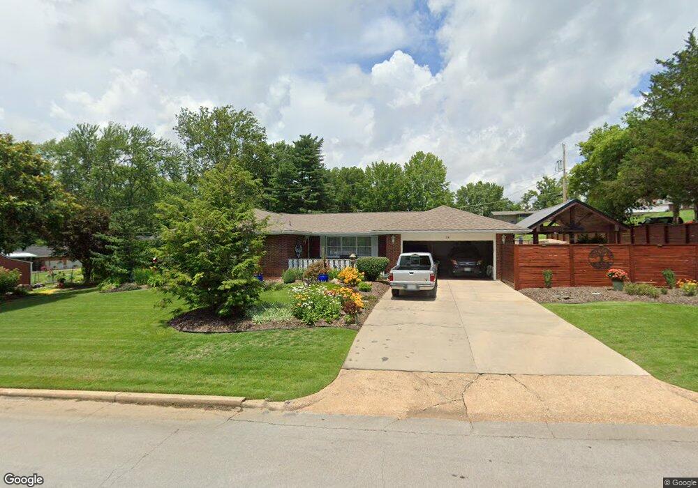
This home is located at 38 Mcfarland Dr, Rolla, MO 65401 and is currently estimated at $260,611, approximately $148 per square foot. 38 Mcfarland Dr is a home located in Phelps County with nearby schools including Rolla Junior High School, Rolla Senior High School, and Rolla Seventh-Day Adventist School.
Ownership History
Date
Name
Owned For
Owner Type
Purchase Details
Closed on
Jun 12, 2014
Current Estimated Value
Purchase Details
Closed on
May 20, 2014
Purchase Details
Closed on
May 16, 2014
Purchase Details
Closed on
Sep 10, 2010
Purchase Details
Closed on
Feb 23, 2005
Purchase Details
Closed on
Apr 14, 2003
Purchase Details
Closed on
Sep 14, 2000
Purchase Details
Closed on
Oct 23, 1992
Purchase Details
Closed on
May 10, 1967
Create a Home Valuation Report for This Property
The Home Valuation Report is an in-depth analysis detailing your home's value as well as a comparison with similar homes in the area
Home Values in the Area
Average Home Value in this Area
Purchase History
| Date | Buyer | Sale Price | Title Company |
|---|---|---|---|
| -- | -- | -- | |
| -- | -- | -- | |
| -- | -- | -- | |
| -- | -- | -- | |
| -- | -- | -- | |
| -- | -- | -- | |
| -- | -- | -- | |
| -- | -- | -- | |
| -- | -- | -- |
Source: Public Records
Tax History
| Year | Tax Paid | Tax Assessment Tax Assessment Total Assessment is a certain percentage of the fair market value that is determined by local assessors to be the total taxable value of land and additions on the property. | Land | Improvement |
|---|---|---|---|---|
| 2025 | $1,842 | $35,290 | $3,850 | $31,440 |
| 2024 | $1,690 | $31,430 | $2,850 | $28,580 |
| 2023 | $1,700 | $31,430 | $2,850 | $28,580 |
| 2022 | $1,444 | $31,430 | $2,850 | $28,580 |
| 2021 | $1,454 | $31,430 | $2,850 | $28,580 |
| 2020 | $1,313 | $27,700 | $2,850 | $24,850 |
| 2019 | $1,306 | $27,700 | $2,850 | $24,850 |
| 2018 | $1,294 | $27,700 | $2,850 | $24,850 |
| 2017 | $1,292 | $27,700 | $2,850 | $24,850 |
| 2016 | $1,250 | $27,700 | $2,850 | $24,850 |
| 2015 | -- | $27,700 | $2,850 | $24,850 |
| 2014 | -- | $27,700 | $2,850 | $24,850 |
| 2013 | -- | $27,700 | $0 | $0 |
Source: Public Records
Map
Nearby Homes
- 45 Mcfarland Dr
- 38 Johnson Dr
- 1102 Sycamore Dr
- Lot 74 B Cedar Hill Ct
- Lot 74 A Cedar Hill Ct
- 622 Scottsvale Dr
- 821 Cambridge Dr
- 909 Cypress Dr
- 60 Richard Dr
- 816 Laurel Dr
- 814 Oxford Dr
- 0 Sherwood Unit MIS25076064
- 1601 E State Route 72
- 1206 Elliott Dr
- 807 Lariat Ln
- 1132 Leonard Ave
- 821 Highway O
- 687 Salem Ave
- 403 Hutchinson Dr
- 1608 Coventry Ln
- 35 Sydney Ct
- 37 Mcfarland Dr
- 39 Mcfarland Dr
- 34 Sydney Ct
- 11 Mcfarland Dr
- 12 Mcfarland Dr
- 36 Mcfarland Dr
- 10 Mcfarland Dr
- 29 Sydney Ct
- 1207 Devonshire Ln
- 13 Mcfarland Dr
- 1209 Devonshire Ln
- 1205 Devonshire Ln
- 33 Sydney Ct
- 15 Mcfarland Dr
- 14 Mcfarland Dr
- 1203 Devonshire Ln
- 26 Mcfarland Dr
- 9 Mcfarland Dr
- 16 Mcfarland Dr
Your Personal Tour Guide
Ask me questions while you tour the home.