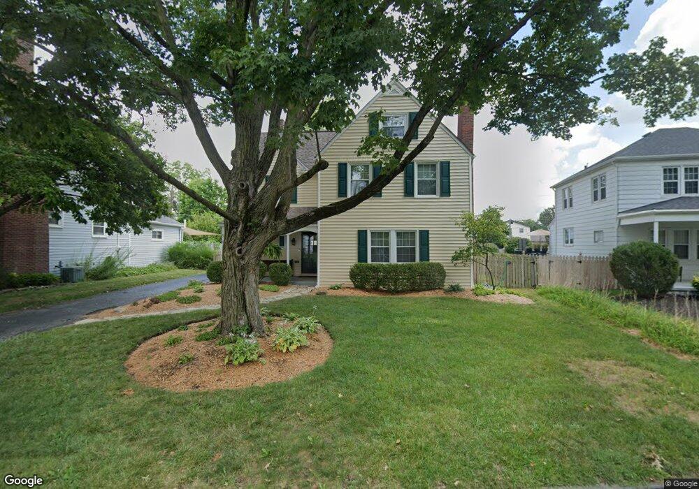
38 Powhatan Ave Columbus, OH 43204
Westgate NeighborhoodEstimated Value: $312,000 - $321,000
3
Beds
2
Baths
1,620
Sq Ft
$196/Sq Ft
Est. Value
About This Home
This home is located at 38 Powhatan Ave, Columbus, OH 43204 and is currently estimated at $317,394, approximately $195 per square foot. 38 Powhatan Ave is a home located in Franklin County with nearby schools including Westgate Alternative Elementary School, Westmoor Middle School, and West High School.
Ownership History
Date
Name
Owned For
Owner Type
Purchase Details
Closed on
Nov 10, 2025
Sold by
Carter Kim L and Caldwell Teresa A
Bought by
Sparks Wolfgang and Villarreal Veronica
Current Estimated Value
Home Financials for this Owner
Home Financials are based on the most recent Mortgage that was taken out on this home.
Original Mortgage
$256,000
Outstanding Balance
$255,280
Interest Rate
6.34%
Mortgage Type
New Conventional
Estimated Equity
$62,114
Purchase Details
Closed on
Feb 19, 2008
Sold by
Rudolph Eugene M and Rudolph Maria
Bought by
Carter Kim L and Caldwell Teresa A
Home Financials for this Owner
Home Financials are based on the most recent Mortgage that was taken out on this home.
Original Mortgage
$166,500
Interest Rate
5.9%
Mortgage Type
Purchase Money Mortgage
Purchase Details
Closed on
Mar 31, 1983
Bought by
Rudolph Eugene M
Create a Home Valuation Report for This Property
The Home Valuation Report is an in-depth analysis detailing your home's value as well as a comparison with similar homes in the area
Home Values in the Area
Average Home Value in this Area
Purchase History
| Date | Buyer | Sale Price | Title Company |
|---|---|---|---|
| Sparks Wolfgang | $320,000 | Search2close | |
| Carter Kim L | $166,500 | Valmer Land | |
| Rudolph Eugene M | -- | -- |
Source: Public Records
Mortgage History
| Date | Status | Borrower | Loan Amount |
|---|---|---|---|
| Open | Sparks Wolfgang | $256,000 | |
| Previous Owner | Carter Kim L | $166,500 |
Source: Public Records
Tax History
| Year | Tax Paid | Tax Assessment Tax Assessment Total Assessment is a certain percentage of the fair market value that is determined by local assessors to be the total taxable value of land and additions on the property. | Land | Improvement |
|---|---|---|---|---|
| 2025 | $3,799 | $84,640 | $21,950 | $62,690 |
| 2024 | $3,799 | $84,640 | $21,950 | $62,690 |
| 2023 | $3,750 | $84,630 | $21,945 | $62,685 |
| 2022 | $3,317 | $63,950 | $9,170 | $54,780 |
| 2021 | $3,323 | $63,950 | $9,170 | $54,780 |
| 2020 | $3,327 | $63,950 | $9,170 | $54,780 |
| 2019 | $3,274 | $53,970 | $7,630 | $46,340 |
| 2018 | $3,067 | $53,970 | $7,630 | $46,340 |
| 2017 | $3,272 | $53,970 | $7,630 | $46,340 |
| 2016 | $3,158 | $47,680 | $8,720 | $38,960 |
| 2015 | $2,867 | $47,680 | $8,720 | $38,960 |
| 2014 | $2,874 | $47,680 | $8,720 | $38,960 |
| 2013 | $1,492 | $50,190 | $9,170 | $41,020 |
Source: Public Records
Map
Nearby Homes
- 77 S Brinker Ave
- 3096 Ellis Place
- 144 S Brinker Ave
- 162 S Southampton Ave
- 122 N Westgate Ave
- 75 N Huron Ave
- 139 Demorest Ave
- 160 S Huron Ave
- 107 Haldy Ave
- 154-156 N Huron Ave
- 328 S Sylvan Ave
- 162 S Roys Ave
- 235 S Roys Ave
- 277 Josephine Ave
- 2816-2820 Steele Ave
- 65 S Hague Ave
- 3001 Wicklow Rd
- 327 S Chase Ave
- 2845 Fremont St
- 363 S Chase Ave
- 46 Powhatan Ave
- 26 Powhatan Ave
- 25 S Algonquin Ave
- 41 Powhatan Ave
- 31 S Algonquin Ave
- 39 S Algonquin Ave
- 47 Powhatan Ave
- 60 Powhatan Ave
- 47 S Algonquin Ave
- 33 Powhatan Ave
- 15 S Algonquin Ave Unit 17
- 55 Powhatan Ave
- 53 S Algonquin Ave
- 66 Powhatan Ave
- 59 S Algonquin Ave
- 63 Powhatan Ave
- 3225 W Broad St
- 34 S Sylvan Ave
- 72 Powhatan Ave
- 65 S Algonquin Ave
Your Personal Tour Guide
Ask me questions while you tour the home.