
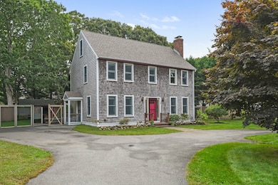
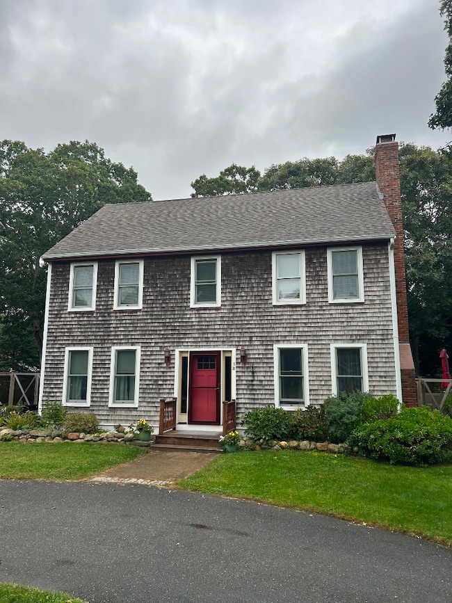
38 Rogers Way Oak Bluffs, MA 02557
Oak Bluffs NeighborhoodEstimated payment $9,140/month
Highlights
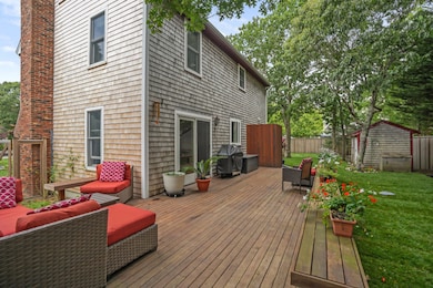
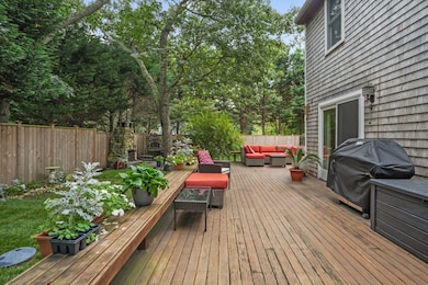
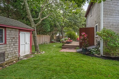
- Deck
- Patio
- Garden
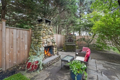
- Fireplace
About This Home
Tucked away in a private desirable Oak Bluffs neighborhood yet only minutes from the charm of downtown and the incredible OB beaches, this home is a wonderful island retreat. With four levels of finished living space, it offers room to gather, relax, entertain, and create memories in every season. Hardwood floors, open concept kitchen and living areas, crackling fireplace set the tone indoors. Step outside and you’ll discover a backyard designed for celebration and entertaining—mature plantings, a built in exterior fireplace that invites long summer evenings, and a wood-fired pizza oven ready for family feasts. The paved circular driveway offers plenty of space for the boat! Every corner of the property has been carefully maintained and thoughtfully updated, from the roof (2019) to the
windows and doors (2020) to the beautiful cedar fence (2024) and all interior paint (2022), so all you have to do is settle in and enjoy. Here, you can bike into town for morning coffee, spend the afternoon at the beach, and return home to evenings under the stars.
This house is move in ready and a rare opportunity in this wonderful neighborhood.
SHOWINGS BEGIN MONDAY 10/20
Listing Agent
Jon Hartzband
Martha's Vineyard Island-Wide Realty Listed on: 10/16/2025
Home Details
Home Type
- Single Family
Est. Annual Taxes
- $5,575
Year Built
- Built in 2000
Lot Details
- 0.25 Acre Lot
- Garden
- Property is zoned R10
HOA Fees
- $21 Monthly HOA Fees
Interior Spaces
- 2,448 Sq Ft Home
- Partially Furnished
- Fireplace
- Stove
- Washer
Bedrooms and Bathrooms
- 3 Bedrooms
Outdoor Features
- Deck
- Patio
Utilities
- Septic Tank
- Cable TV Available
Community Details
- Association fees include road
Listing and Financial Details
- Tax Lot 177-13
- $582,800 per year additional tax assessments
Map
Home Values in the Area
Average Home Value in this Area
Tax History
| Year | Tax Paid | Tax Assessment Tax Assessment Total Assessment is a certain percentage of the fair market value that is determined by local assessors to be the total taxable value of land and additions on the property. | Land | Improvement |
|---|---|---|---|---|
| 2025 | $6,265 | $1,240,600 | $582,800 | $657,800 |
| 2024 | $6,184 | $1,182,400 | $529,600 | $652,800 |
| 2023 | $5,402 | $1,023,100 | $514,600 | $508,500 |
| 2022 | $5,536 | $815,300 | $387,600 | $427,700 |
| 2021 | $5,336 | $724,000 | $331,100 | $392,900 |
| 2020 | $5,062 | $680,400 | $315,300 | $365,100 |
| 2019 | $4,975 | $647,000 | $288,900 | $358,100 |
| 2018 | $4,593 | $586,600 | $240,000 | $346,600 |
| 2017 | $4,321 | $530,200 | $227,500 | $302,700 |
| 2016 | $4,015 | $495,100 | $234,500 | $260,600 |
| 2015 | $3,867 | $485,800 | $244,700 | $241,100 |
| 2014 | $3,866 | $495,000 | $250,200 | $244,800 |
Property History
| Date | Event | Price | List to Sale | Price per Sq Ft |
|---|---|---|---|---|
| 10/16/2025 10/16/25 | For Sale | $1,650,000 | -- | $674 / Sq Ft |
Purchase History
| Date | Type | Sale Price | Title Company |
|---|---|---|---|
| Deed | -- | -- | |
| Deed | $69,000 | -- |
Mortgage History
| Date | Status | Loan Amount | Loan Type |
|---|---|---|---|
| Open | $325,000 | No Value Available | |
| Closed | $417,000 | No Value Available |
Source: LINK (Vineyard)
MLS Number: 43756
APN: 12 0 177 13
- 25 Windy Hill Rd
- 60 -R Carol Ln
- 60R Carol Ln
- 70 Carol Ln
- 9 Bayview Ave
- 8 Hitchings Cir
- 30 Franklin Ave
- 26 Winthrop Ave
- 54 Towanticut Ave
- 113 Dukes County Ave Unit Multi-Family
- 24 School St
- 48 Vineyard Avenue Extension
- 181 Circuit Ave
- 26 Hampson Ave
- 0-A California Ave Unit Part lot 79
- 0-B California Ave Unit Part lot 79
- 0 California Ave Unit 76 42933
- 9 Brunswick Ave
- 25 Hampson Ave
- 6 Sachem Way
- 59 Prospect Ave Ob502
- 5 Laurel Ave
- 14 Pulpit Rock Rd
- 291 Barnes Rd Ob516
- 55 Samoset Ave
- 55 Samoset Ave Unit 1
- 9 Tuckernuck Ave
- 155 Skiff Ave
- 11 High Meadow Ln
- 21 William St Vh430
- 385 Barnes Rd Ob534
- 14 Bernard Cir
- 100 Franklin Terrace Vh411
- 256 Sandpiper Lane Vh417
- 223 Sandpiper Lane Vh405
- 40 Hidden Cove Rd
- 16 Majors Cove Ln
- 83 Ashtons Way
- 100 Connie's Way Vh401
- 100 Connie's Way &83 Ashtonw Vh408