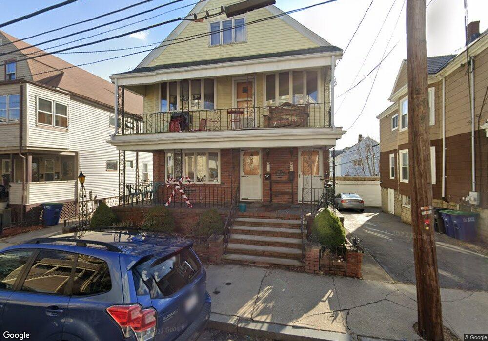
38 Whitman St Somerville, MA 02144
Davis Square NeighborhoodEstimated Value: $1,414,000 - $1,661,000
4
Beds
2
Baths
2,910
Sq Ft
$532/Sq Ft
Est. Value
About This Home
This home is located at 38 Whitman St, Somerville, MA 02144 and is currently estimated at $1,547,686, approximately $531 per square foot. 38 Whitman St is a home located in Middlesex County with nearby schools including Somerville High School, Benjamin Banneker Charter Public School, and St. Clement Elementary School.
Ownership History
Date
Name
Owned For
Owner Type
Purchase Details
Closed on
Jul 28, 2023
Sold by
Letteri Anna T
Bought by
Letteri Ft and Letteri
Current Estimated Value
Purchase Details
Closed on
Sep 5, 2008
Sold by
Letteri Anna T
Bought by
Letteri Anna T and Letteri Giuseppe
Purchase Details
Closed on
Dec 22, 2004
Sold by
Atl Rt and Donovan
Bought by
Donovan Timothy M
Create a Home Valuation Report for This Property
The Home Valuation Report is an in-depth analysis detailing your home's value as well as a comparison with similar homes in the area
Home Values in the Area
Average Home Value in this Area
Purchase History
| Date | Buyer | Sale Price | Title Company |
|---|---|---|---|
| Letteri Ft | -- | None Available | |
| Letteri Anna T | -- | -- | |
| Donovan Timothy M | -- | -- |
Source: Public Records
Property History
| Date | Event | Price | List to Sale | Price per Sq Ft |
|---|---|---|---|---|
| 02/10/2025 02/10/25 | Off Market | $2,800 | -- | -- |
| 01/20/2025 01/20/25 | For Rent | -- | -- | -- |
| 10/08/2024 10/08/24 | Off Market | $2,800 | -- | -- |
| 11/05/2020 11/05/20 | For Rent | $2,800 | -- | -- |
Tax History
| Year | Tax Paid | Tax Assessment Tax Assessment Total Assessment is a certain percentage of the fair market value that is determined by local assessors to be the total taxable value of land and additions on the property. | Land | Improvement |
|---|---|---|---|---|
| 2025 | $13,351 | $1,223,700 | $694,300 | $529,400 |
| 2024 | $12,775 | $1,214,400 | $694,300 | $520,100 |
| 2023 | $12,193 | $1,179,200 | $694,300 | $484,900 |
| 2022 | $11,478 | $1,127,500 | $661,200 | $466,300 |
| 2021 | $11,180 | $1,097,200 | $656,400 | $440,800 |
| 2020 | $10,816 | $1,072,000 | $656,800 | $415,200 |
| 2019 | $10,004 | $929,700 | $597,900 | $331,800 |
| 2018 | $9,305 | $822,700 | $543,600 | $279,100 |
| 2017 | $9,118 | $781,300 | $512,800 | $268,500 |
| 2016 | $8,804 | $702,600 | $458,000 | $244,600 |
| 2015 | $8,391 | $665,400 | $422,900 | $242,500 |
Source: Public Records
Map
Nearby Homes
- 69 Electric Ave Unit 3
- 69 Electric Ave Unit 1
- 55 Packard Ave Unit 1
- 30 Clarendon Ave
- 5 Glendale Ave Unit 5
- 69 Clarendon Ave Unit A
- 202 Powder House Blvd Unit 1
- 202 Powder House Blvd Unit 2
- 17 Holland St Unit 301
- 50 Howard St Unit 5
- 8 Seven Pines Ave
- 32 Cameron Ave
- 26 Warner St
- 233 Powder House Blvd
- 97 Elmwood St Unit 313
- 97 Elmwood St Unit 110
- 97 Elmwood St Unit 310
- 2353 Massachusetts Ave Unit 73
- 68 Winslow Ave
- 9-11 Edmunds St
- 38 Whitman St
- 38 Whitman St Unit 1
- 40 Whitman St Unit 2
- 44 Whitman St Unit 1
- 42 Whitman St Unit 1
- 42 Whitman St
- 34 Whitman St
- 48 Whitman St Unit 2
- 46 Whitman St Unit 1
- 32 Whitman St Unit n/a
- 30 Whitman St Unit 1
- 39 Whitman St
- 39 Whitman St Unit 2
- 1051 Broadway
- 1051 Broadway Unit 2
- 1051 Broadway
- 1049 Broadway Unit 1
- 1051 Broadway Unit U
- 1049 Broadway
- 1055 Broadway
Your Personal Tour Guide
Ask me questions while you tour the home.