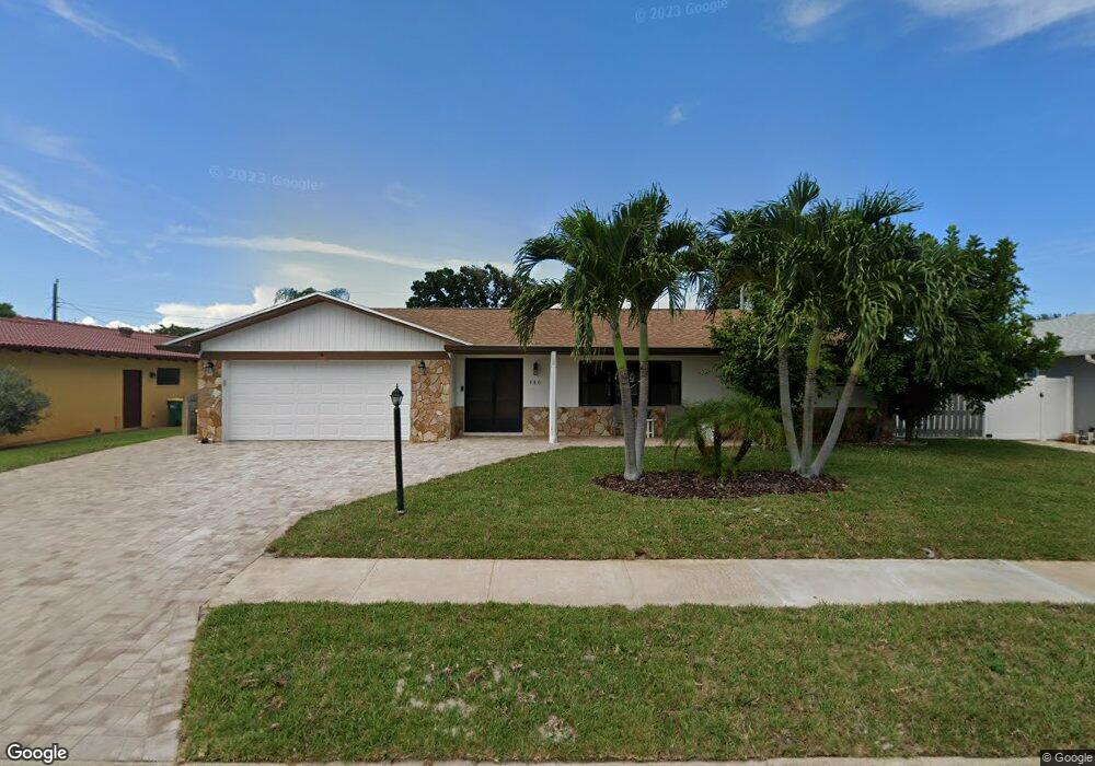
380 Desoto Pkwy Satellite Beach, FL 32937
Estimated Value: $604,000 - $670,000
3
Beds
2
Baths
2,127
Sq Ft
$300/Sq Ft
Est. Value
About This Home
This home is located at 380 Desoto Pkwy, Satellite Beach, FL 32937 and is currently estimated at $637,327, approximately $299 per square foot. 380 Desoto Pkwy is a home located in Brevard County with nearby schools including Surfside Elementary School, Satellite Senior High School, and DeLaura Middle School.
Ownership History
Date
Name
Owned For
Owner Type
Purchase Details
Closed on
Feb 20, 1997
Sold by
Sullivan Thomas D
Bought by
Baneshgar Frank
Current Estimated Value
Purchase Details
Closed on
Feb 2, 1995
Sold by
Sullivan Thomas D and Sullivan Marion V
Bought by
Thomas D Sullivan Family Tr
Purchase Details
Closed on
Nov 11, 1994
Sold by
Sullivan Thomas D and Sullivan Marion V
Bought by
Sullivan Thomas D
Create a Home Valuation Report for This Property
The Home Valuation Report is an in-depth analysis detailing your home's value as well as a comparison with similar homes in the area
Home Values in the Area
Average Home Value in this Area
Purchase History
| Date | Buyer | Sale Price | Title Company |
|---|---|---|---|
| Baneshgar Frank | $125,000 | -- | |
| Sullivan Thomas D | -- | -- | |
| Thomas D Sullivan Family Tr | -- | -- | |
| Sullivan Thomas D | -- | -- | |
| Sullivan Thomas D | -- | -- |
Source: Public Records
Tax History Compared to Growth
Tax History
| Year | Tax Paid | Tax Assessment Tax Assessment Total Assessment is a certain percentage of the fair market value that is determined by local assessors to be the total taxable value of land and additions on the property. | Land | Improvement |
|---|---|---|---|---|
| 2025 | $3,329 | $215,520 | -- | -- |
| 2024 | $3,277 | $209,450 | -- | -- |
| 2023 | $3,277 | $203,350 | $0 | $0 |
| 2022 | $2,714 | $177,690 | $0 | $0 |
| 2021 | $2,795 | $172,520 | $0 | $0 |
| 2020 | $2,785 | $170,140 | $0 | $0 |
| 2019 | $2,764 | $166,320 | $0 | $0 |
| 2018 | $2,765 | $163,220 | $0 | $0 |
| 2017 | $2,591 | $159,870 | $0 | $0 |
| 2016 | $2,598 | $156,590 | $85,000 | $71,590 |
| 2015 | $2,661 | $155,510 | $75,000 | $80,510 |
| 2014 | $2,664 | $154,280 | $70,000 | $84,280 |
Source: Public Records
Map
Nearby Homes
- 431 E Amherst Cir
- 435 Desoto Pkwy
- 620 Jamaica Blvd
- 550 Temple St
- 690 Trinidad Ct
- 235 S Marco Way
- 445 Saint Johns Dr
- 105 Carissa Dr
- 302 Markley Ct
- 484 Greenway Ave
- 502 Bay Cir
- 215 S Robert Way
- 527 Summerset Ct
- 426 Hawthorne Ct Unit G2
- 155 Elm Ave
- 368 Ocean Spray Ave
- 366 Ocean Spray Ave
- 443 Hawthorne Ct
- 199 Skyline Ct
- 43 Anchor Dr
- 388 Desoto Pkwy
- 378 Desoto Pkwy
- 395 Carissa Dr
- 405 Carissa Dr
- 390 Desoto Pkwy
- 370 Desoto Pkwy
- 385 Carissa Dr
- 415 Carissa Dr
- 375 Carissa Dr
- 375 Desoto Pkwy
- 385 Desoto Pkwy
- 360 Desoto Pkwy
- 398 Desoto Pkwy
- 585 Kale St
- 365 Desoto Pkwy
- 389 Desoto Pkwy
- 430 Carissa Dr
- 475 Carissa Dr
- 581 Kale St
- 365 Carissa Dr