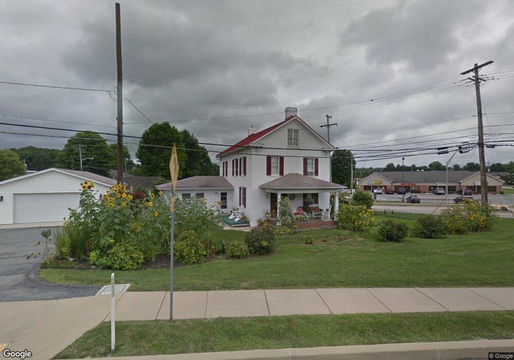
380 N Main St Spring Grove, PA 17362
Estimated Value: $252,000 - $305,000
3
Beds
2
Baths
1,634
Sq Ft
$169/Sq Ft
Est. Value
About This Home
This home is located at 380 N Main St, Spring Grove, PA 17362 and is currently estimated at $276,623, approximately $169 per square foot. 380 N Main St is a home located in York County with nearby schools including Spring Grove Area Middle School, Spring Grove Area High School, and St Rose Of Lima School.
Ownership History
Date
Name
Owned For
Owner Type
Purchase Details
Closed on
Jan 16, 2004
Sold by
Rebert Mary C and Longstreth Mary C
Bought by
Longstreth Mary C
Current Estimated Value
Home Financials for this Owner
Home Financials are based on the most recent Mortgage that was taken out on this home.
Original Mortgage
$108,000
Interest Rate
5.82%
Mortgage Type
New Conventional
Create a Home Valuation Report for This Property
The Home Valuation Report is an in-depth analysis detailing your home's value as well as a comparison with similar homes in the area
Home Values in the Area
Average Home Value in this Area
Purchase History
| Date | Buyer | Sale Price | Title Company |
|---|---|---|---|
| Longstreth Mary C | -- | -- |
Source: Public Records
Mortgage History
| Date | Status | Borrower | Loan Amount |
|---|---|---|---|
| Closed | Longstreth Mary C | $108,000 |
Source: Public Records
Tax History Compared to Growth
Tax History
| Year | Tax Paid | Tax Assessment Tax Assessment Total Assessment is a certain percentage of the fair market value that is determined by local assessors to be the total taxable value of land and additions on the property. | Land | Improvement |
|---|---|---|---|---|
| 2025 | $4,620 | $123,680 | $30,830 | $92,850 |
| 2024 | $4,575 | $123,680 | $30,830 | $92,850 |
| 2023 | $4,575 | $123,680 | $30,830 | $92,850 |
| 2022 | $4,575 | $123,680 | $30,830 | $92,850 |
| 2021 | $4,399 | $123,680 | $30,830 | $92,850 |
| 2020 | $4,368 | $123,680 | $30,830 | $92,850 |
| 2019 | $4,284 | $123,680 | $30,830 | $92,850 |
| 2018 | $4,109 | $123,680 | $30,830 | $92,850 |
| 2017 | $4,023 | $123,680 | $30,830 | $92,850 |
| 2016 | $0 | $123,680 | $30,830 | $92,850 |
| 2015 | -- | $123,680 | $30,830 | $92,850 |
| 2014 | -- | $123,680 | $30,830 | $92,850 |
Source: Public Records
Map
Nearby Homes
- 145 N Main St
- 156 N Walnut St
- 46 N Main St
- 214 Hauer Terrace
- 568 Monocacy Trail
- 540 Monocacy Trail
- St. Michaels Model 5 Monocacy Trail
- 544 Monocacy Trail
- 562 Monocacy Trail
- 560 Monocacy Trail
- 1934 Forge Heights Ln
- 6030 Deborah Dr
- 6132 Deborah Dr
- 1487 Kbs Rd
- 1941 Cedar Dr
- Lot # 2 Midhill Rd
- Lot # 1 Midhill Rd
- Lot# 3 Midhill Rd
- 6605 Woodland Dr
- 335 Cape Climb
- 350 N Main St
- 349 N Main St
- 40 W Hanover St
- 339 N Main St
- 31 W Hanover St Unit 4
- 0 W Hanover St
- 336 N Main St
- 331 N Main St
- 44 W Hanover St
- 324 N Main St
- 22-26 Roths Church Rd
- 405 N Pine Ave
- 321 N Main St
- 5 Campus Ave
- 52 W Hanover St
- Lt 12 Pigeon Hill Rd
- Lot Gnatstown Rd
- Tract 3 Rockville Rd
- 4508 Moulstown Rd
- LOT #1 Slagel Rd (10-Acres)