
Seller's Agent in 2026
Tom Jones
Elite Mississippi Real Estate
(251) 377-5974
1 in this area
122 Total Sales

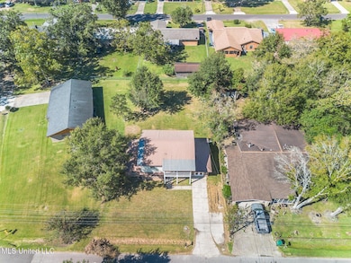

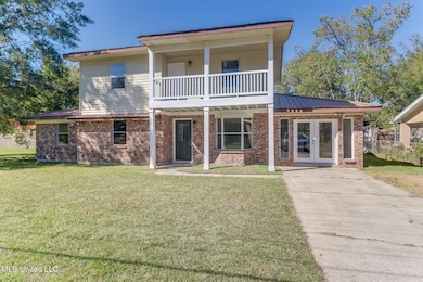
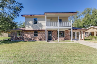
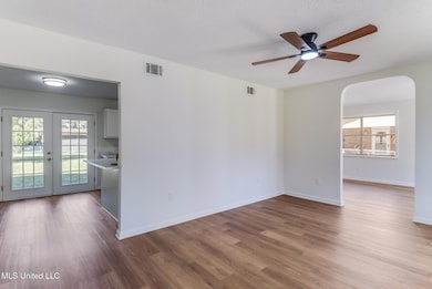
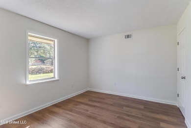
Are you looking for a large home under $200,000? Come see this one. New LVP flooring, New HVAC and new appliances.
Primary bedroom is downstairs.
Last Agent to Sell the Property
Elite Mississippi Real Estate License #S59487 Listed on: 10/22/2025
| Date | Type | Sale Price | Title Company |
|---|---|---|---|
| Warranty Deed | -- | Pilger Title | |
| Warranty Deed | -- | -- | |
| Quit Claim Deed | -- | Murphy-Government Street Lan |
| Date | Status | Loan Amount | Loan Type |
|---|---|---|---|
| Open | $171,830 | FHA | |
| Previous Owner | $2,981 | Unknown | |
| Previous Owner | $99,384 | FHA |
| Date | Event | Price | List to Sale | Price per Sq Ft |
|---|---|---|---|---|
| 01/07/2026 01/07/26 | Sold | -- | -- | -- |
| 11/15/2025 11/15/25 | Pending | -- | -- | -- |
| 11/03/2025 11/03/25 | Price Changed | $179,500 | -10.0% | $78 / Sq Ft |
| 10/22/2025 10/22/25 | For Sale | $199,500 | -- | $86 / Sq Ft |
| Year | Tax Paid | Tax Assessment Tax Assessment Total Assessment is a certain percentage of the fair market value that is determined by local assessors to be the total taxable value of land and additions on the property. | Land | Improvement |
|---|---|---|---|---|
| 2025 | $1,675 | $9,754 | $710 | $9,044 |
| 2024 | $1,675 | $9,571 | $687 | $8,884 |
| 2023 | $1,643 | $9,571 | $687 | $8,884 |
| 2022 | $0 | $6,381 | $458 | $5,923 |
| 2021 | $0 | $6,419 | $458 | $5,961 |
| 2020 | $0 | $6,606 | $526 | $6,080 |
| 2019 | $0 | $6,606 | $526 | $6,080 |
| 2018 | $0 | $6,606 | $526 | $6,080 |
| 2017 | $0 | $6,606 | $526 | $6,080 |
| 2016 | $0 | $6,606 | $526 | $6,080 |
| 2015 | -- | $66,880 | $5,260 | $61,620 |
| 2014 | -- | $6,905 | $526 | $6,379 |
| 2013 | -- | $6,905 | $526 | $6,379 |
Seller's Agent in 2026
Tom Jones
Elite Mississippi Real Estate
(251) 377-5974
1 in this area
122 Total Sales
Seller Co-Listing Agent in 2026
Sheri Hussey-Jones
Elite Mississippi Real Estate
(251) 377-5974
1 in this area
131 Total Sales
Buyer's Agent in 2026
Ken Harshbarger
Ellis Realty
(228) 343-3665
2 in this area
239 Total Sales
Source: MLS United
MLS Number: 4129424
APN: 2-16-45-046.000
Disclaimer: Certain information contained herein is derived from information provided by parties other than Homes.com. All information provided is deemed reliable, but is not guaranteed to be accurate and should be independently verified.
![]() Information is deemed to be reliable but not guaranteed. Copyright 2026 MLS United, LLC.
Information is deemed to be reliable but not guaranteed. Copyright 2026 MLS United, LLC.
Ask me questions while you tour the home.