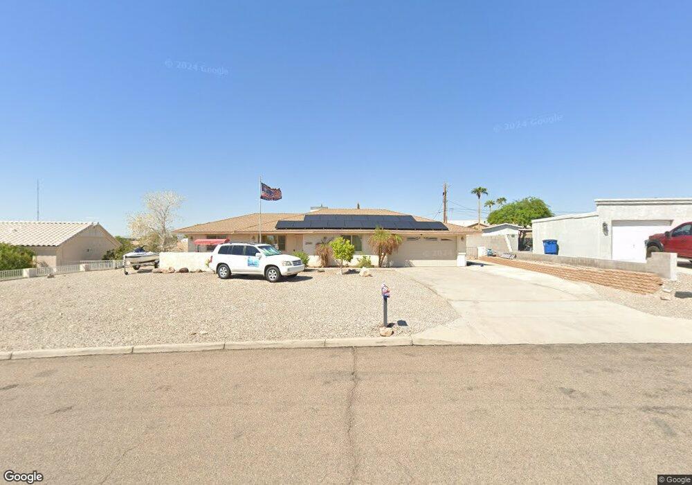
3801 Sloop Dr Lake Havasu City, AZ 86406
Estimated Value: $456,000 - $491,000
2
Beds
1
Bath
1,462
Sq Ft
$321/Sq Ft
Est. Value
About This Home
This home is located at 3801 Sloop Dr, Lake Havasu City, AZ 86406 and is currently estimated at $468,591, approximately $320 per square foot. 3801 Sloop Dr is a home located in Mohave County with nearby schools including Jamaica Elementary School, Thunderbolt Middle School, and Lake Havasu High School.
Ownership History
Date
Name
Owned For
Owner Type
Purchase Details
Closed on
Mar 26, 2007
Sold by
Walch Elizabeth and Walch Michael T
Bought by
Walch Elizabeth
Current Estimated Value
Home Financials for this Owner
Home Financials are based on the most recent Mortgage that was taken out on this home.
Original Mortgage
$200,000
Outstanding Balance
$121,258
Interest Rate
6.2%
Mortgage Type
Stand Alone Refi Refinance Of Original Loan
Estimated Equity
$347,334
Purchase Details
Closed on
Feb 2, 2006
Sold by
Anderson Elizabeth
Bought by
Walch Elizabeth and Walch Michael T
Purchase Details
Closed on
Mar 31, 2005
Sold by
Staib Daniel Walter and Staib Josephine Delia
Bought by
Anderson Elizabeth
Home Financials for this Owner
Home Financials are based on the most recent Mortgage that was taken out on this home.
Original Mortgage
$115,000
Interest Rate
5.77%
Mortgage Type
New Conventional
Create a Home Valuation Report for This Property
The Home Valuation Report is an in-depth analysis detailing your home's value as well as a comparison with similar homes in the area
Home Values in the Area
Average Home Value in this Area
Purchase History
| Date | Buyer | Sale Price | Title Company |
|---|---|---|---|
| Walch Elizabeth | -- | None Available | |
| Walch Elizabeth | -- | None Available | |
| Anderson Elizabeth | $224,000 | Capital Title Agency Inc |
Source: Public Records
Mortgage History
| Date | Status | Borrower | Loan Amount |
|---|---|---|---|
| Open | Walch Elizabeth | $200,000 | |
| Previous Owner | Anderson Elizabeth | $115,000 |
Source: Public Records
Tax History Compared to Growth
Tax History
| Year | Tax Paid | Tax Assessment Tax Assessment Total Assessment is a certain percentage of the fair market value that is determined by local assessors to be the total taxable value of land and additions on the property. | Land | Improvement |
|---|---|---|---|---|
| 2026 | $667 | -- | -- | -- |
| 2025 | $1,352 | $38,459 | $0 | $0 |
| 2024 | $1,352 | $39,168 | $0 | $0 |
| 2023 | $1,352 | $33,567 | $0 | $0 |
| 2022 | $1,302 | $24,267 | $0 | $0 |
| 2021 | $1,493 | $24,321 | $0 | $0 |
| 2019 | $1,420 | $19,999 | $0 | $0 |
| 2018 | $1,373 | $18,421 | $0 | $0 |
| 2017 | $1,350 | $17,759 | $0 | $0 |
| 2016 | $1,199 | $16,168 | $0 | $0 |
| 2015 | $1,167 | $13,996 | $0 | $0 |
Source: Public Records
Map
Nearby Homes
- 3808 Whaler Dr
- 3665 Pelican Place
- 3873 Packard Place
- 3751 Mission Dr S
- 3781 Bluegrass Dr
- 3830 Bluegrass Dr
- 3828 Cherry Tree Blvd
- 3883 Sloop Dr
- 3716 Sloop Ln
- 3770 Bluegrass Dr
- 361 Mcculloch Blvd S
- 3856 Mission Dr N
- 386 Mcculloch Blvd S
- 3852 Solar Dr
- 4019 Bluegrass Dr
- 3956 Cherry Tree Blvd
- 3565 El Rey Ln
- 3541 Chesapeake
- 3937 Comet Dr
- 3888 Lighthouse Dr
- 3807 Sloop Dr
- 3797 Sloop Dr
- 3811 Sloop Dr
- 3796 Sloop Dr
- 3732 Cattail Dr
- 3791 Sloop Dr
- 3738 Cattail Dr
- 3790 Sloop Dr
- 3726 Cattail Dr
- 3800 Sloop Dr
- 3744 Cattail Dr
- 3710 Mission Dr S
- 3817 Sloop Dr
- 3714 Mission Dr S
- 3806 Sloop Dr
- 3708 Mission Dr S
- 3708 Mission Dr S
- 3750 Cattail Dr
- 3821 Sloop Dr
- 3813 Whaler Dr