Estimated Value: $130,758 - $283,000
3
Beds
1
Bath
1,904
Sq Ft
$107/Sq Ft
Est. Value
About This Home
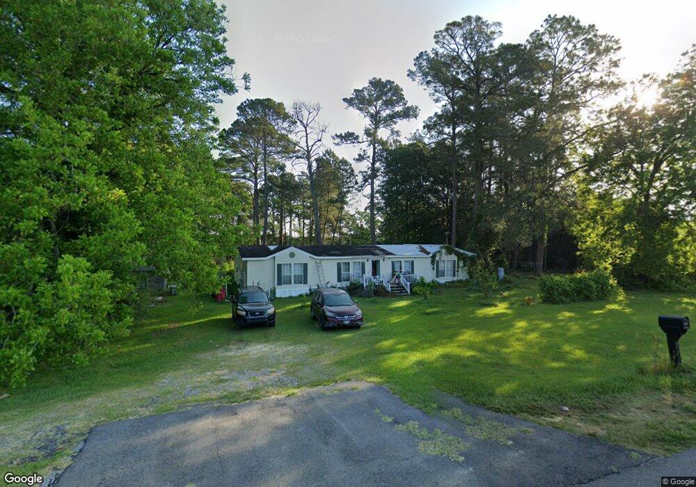
This home is located at 3801 Us Highway 82 E, Ty Ty, GA 31795 and is currently estimated at $203,690, approximately $106 per square foot. 3801 Us Highway 82 E is a home with nearby schools including Worth County Primary School, Worth County Elementary School, and Worth County Middle School.
Ownership History
Date
Name
Owned For
Owner Type
Purchase Details
Closed on
Apr 7, 2014
Sold by
Sec Of Housing & U
Bought by
Fischer Thomas C and Fischer Debra S
Current Estimated Value
Purchase Details
Closed on
Oct 16, 2012
Sold by
Goodman Kyle
Bought by
Sec Of Housing & Urban
Purchase Details
Closed on
Feb 5, 2010
Sold by
Souter Wanda W
Bought by
Goodman Kyle
Home Financials for this Owner
Home Financials are based on the most recent Mortgage that was taken out on this home.
Original Mortgage
$61,367
Interest Rate
5.07%
Mortgage Type
FHA
Create a Home Valuation Report for This Property
The Home Valuation Report is an in-depth analysis detailing your home's value as well as a comparison with similar homes in the area
Home Values in the Area
Average Home Value in this Area
Purchase History
| Date | Buyer | Sale Price | Title Company |
|---|---|---|---|
| Fischer Thomas C | $19,011 | -- | |
| Sec Of Housing & Urban | -- | -- | |
| Goodman Kyle | $62,500 | -- | |
| Goodman Kyle | -- | -- |
Source: Public Records
Mortgage History
| Date | Status | Borrower | Loan Amount |
|---|---|---|---|
| Previous Owner | Goodman Kyle | $61,367 |
Source: Public Records
Tax History Compared to Growth
Tax History
| Year | Tax Paid | Tax Assessment Tax Assessment Total Assessment is a certain percentage of the fair market value that is determined by local assessors to be the total taxable value of land and additions on the property. | Land | Improvement |
|---|---|---|---|---|
| 2024 | $1,197 | $32,672 | $1,880 | $30,792 |
| 2023 | $1,197 | $32,672 | $1,880 | $30,792 |
| 2022 | $1,192 | $32,458 | $1,880 | $30,578 |
| 2021 | $1,168 | $32,458 | $1,880 | $30,578 |
| 2020 | $1,170 | $32,458 | $1,880 | $30,578 |
| 2019 | $1,170 | $32,458 | $1,880 | $30,578 |
| 2018 | $930 | $32,458 | $1,880 | $30,578 |
| 2017 | $930 | $32,458 | $1,880 | $30,578 |
| 2016 | $930 | $32,458 | $1,880 | $30,578 |
| 2015 | $932 | $32,458 | $1,880 | $30,578 |
| 2014 | $932 | $32,458 | $1,880 | $30,578 |
| 2012 | -- | $1,716 | $1,316 | $400 |
Source: Public Records
Map
Nearby Homes
- 0 Jones Rd
- 1583 Gibbs Rd
- 1017 Sumner Rd S
- 0 U S 82
- 5.9 ac Cherry St
- 0 U S Highway 82
- 6 Ilene Glover Rd
- 1.91 ac Hwy 82 W Cherry St
- 112 Courtney Cir
- 102 Courtney Cir
- 1.86 ac Highway 82 Cherry St
- 376 West Rd
- Cottle Rd
- 4341 U S 82
- 4341 U S 82
- 0 Sands Dr
- 565 Sands Dr Unit 8
- 565 Sands Dr
- 914 Douthit Rd
- 6 Green Rd