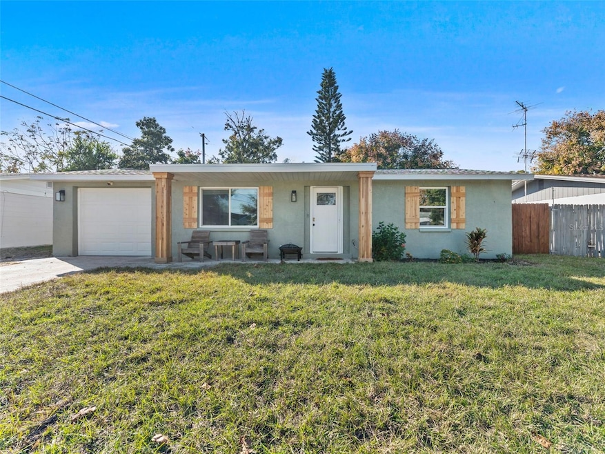
3809 Brock St New Port Richey, FL 34652
Estimated payment $1,734/month
Highlights
- Open Floorplan
- 1 Car Attached Garage
- Central Heating and Cooling System
- No HOA
- Tile Flooring
- Combination Dining and Living Room
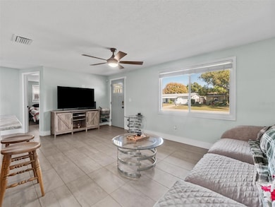
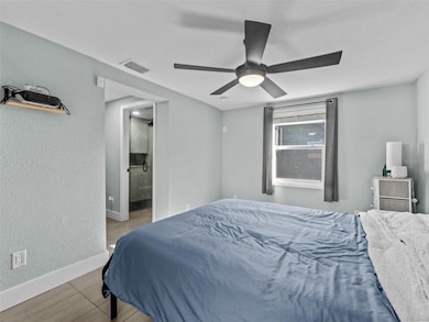
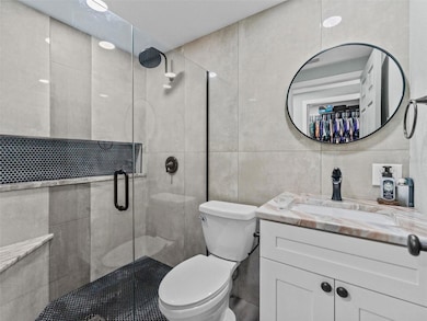
About This Home
Fully updated 3-bed, 2-bath block home: 1,056 heated sq ft, 1-car garage, fenced backyard. Move-in ready!
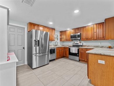
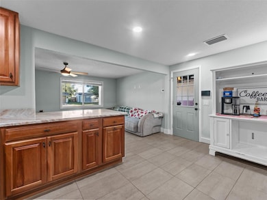
All major systems newer. Roof, HVAC, septic,, windows, water heater, tile flooring, paint, LED lights, and more. Gourmet kitchen w/ shaker cabinets, granite countertops, SS appliances. Updated baths w/ modern vanities and fixtures.
Prime spot near US-19 & SR-54: mins to shopping, dining, schools, Trinity Medical Center, Gulf beaches (5 min), Tampa Airport (40 min).
Ideal for first-timers, downsizers, investors. No HOA/flood zone
Listing Agent
THE SOMERDAY GROUP PL Brokerage Phone: 813-520-9123 License #3300270 Listed on: 11/25/2025
Home Details
Home Type
- Single Family
Est. Annual Taxes
- $3,381
Year Built
- Built in 1963
Lot Details
- 5,820 Sq Ft Lot
- East Facing Home
- Property is zoned R4
Parking
- 1 Car Attached Garage
Home Design
- Block Foundation
- Shingle Roof
- Block Exterior
Interior Spaces
- 1,056 Sq Ft Home
- 1-Story Property
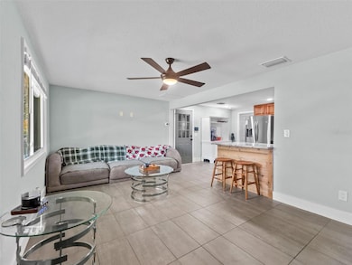
- Open Floorplan
- Combination Dining and Living Room
- Tile Flooring
- Laundry in unit
Kitchen
- Microwave
- Dishwasher
Bedrooms and Bathrooms
- 3 Bedrooms
- 2 Full Bathrooms
Utilities
- Central Heating and Cooling System
- Septic Tank
- High Speed Internet
Community Details
- No Home Owners Association
- Beacon Hill Subdivision
Listing and Financial Details
- Visit Down Payment Resource Website
- Legal Lot and Block 73 / 0730
- Assessor Parcel Number 16-26-19-002.0-000.00-073.0
Map
Home Values in the Area
Average Home Value in this Area
Tax History
| Year | Tax Paid | Tax Assessment Tax Assessment Total Assessment is a certain percentage of the fair market value that is determined by local assessors to be the total taxable value of land and additions on the property. | Land | Improvement |
|---|---|---|---|---|
| 2025 | $3,381 | $191,065 | $36,259 | $154,806 |
| 2024 | $3,381 | $196,145 | $36,259 | $159,886 |
| 2023 | $3,043 | $163,730 | $0 | $0 |
| 2022 | $2,535 | $147,940 | $20,137 | $127,803 |
| 2021 | $1,434 | $105,249 | $15,714 | $89,535 |
| 2020 | $1,286 | $89,657 | $15,423 | $74,234 |
| 2019 | $1,177 | $78,767 | $15,423 | $63,344 |
| 2018 | $1,061 | $65,730 | $12,222 | $53,508 |
| 2017 | $982 | $56,906 | $12,222 | $44,684 |
| 2016 | $810 | $41,274 | $11,640 | $29,634 |
| 2015 | $765 | $37,720 | $11,640 | $26,080 |
| 2014 | $669 | $31,209 | $8,730 | $22,479 |
Property History
| Date | Event | Price | List to Sale | Price per Sq Ft |
|---|---|---|---|---|
| 11/25/2025 11/25/25 | For Sale | $274,900 | -- | $260 / Sq Ft |
Purchase History
| Date | Type | Sale Price | Title Company |
|---|---|---|---|
| Warranty Deed | $86,000 | Haven Title Llc | |
| Warranty Deed | $86,000 | Haven Title | |
| Warranty Deed | $68,000 | Haven Title Llc | |
| Warranty Deed | $68,000 | Haven Title | |
| Warranty Deed | $60,000 | -- |
Mortgage History
| Date | Status | Loan Amount | Loan Type |
|---|---|---|---|
| Previous Owner | $57,000 | New Conventional |
Source: Stellar MLS
MLS Number: TB8451400
APN: 19-26-16-0020-00000-0730
Disclaimer: Certain information contained herein is derived from information provided by parties other than Homes.com. All information provided is deemed reliable, but is not guaranteed to be accurate and should be independently verified.
![]() IDX information is provided exclusively for personal, non-commercial use, and may not be used for any purpose other than to identify prospective properties consumers may be interested in purchasing. Information is deemed reliable but not guaranteed.
IDX information is provided exclusively for personal, non-commercial use, and may not be used for any purpose other than to identify prospective properties consumers may be interested in purchasing. Information is deemed reliable but not guaranteed.
Listing Information presented by local MLS brokerage: Ten-X - (888)-952-6393
- 3802 Cullen St
- 4708 Salem Dr
- 4715 Manor Dr
- 3648 Bedford St
- 4906 Uranus Ave
- 3744 Carron St
- 3624 Cantrell St
- 3640 Connon Dr
- 3651 Colonial Hills Dr
- 3542 Connon Dr
- 3838 Lanyard Ct Unit B
- 3832 Lanyard Ct
- 4446 Chart Ct
- 3705 U S Hwy 19
- 5040 Beacon Hill Dr
- 3522 Cambridge St
- 5053 Mecaslin Dr
- 4424 Pelorus Dr
- 4423 Pelorus Dr Unit B
- 3862 Lighthouse Way
- 3621 Latimer St
- 3600 Berkshire St
- 3607 Cambridge St
- 5015 Overton Dr
- 3508 Bedford St
- 5122 Dove Dr
- 5128 Dove Dr
- 3610 Pinehurst Dr
- 4219 Sheldon Place
- 4219 Sheldon Place Unit 4219
- 3415 Tricon Ln Unit 24
- 4222 Trucious Place Unit 3014B
- 4223 Craftsbury Dr
- 3902 Glissade Dr
- 5041 Fitchburg Dr
- 4636 Irene Loop Unit 1
- 4031 Claremont Dr
- 4428 Sunstate Dr Unit A
- 4009 Bancroft Dr
- 5424 Drift Tide Dr
