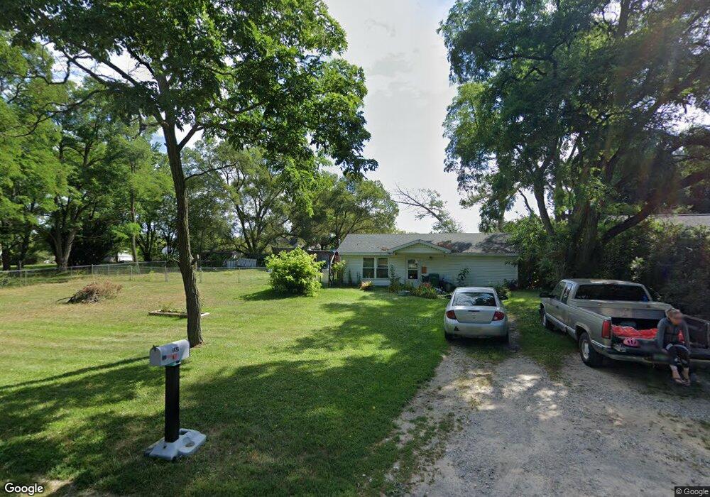
381 3rd St N Oscoda, MI 48750
Estimated Value: $121,000 - $142,353
3
Beds
1
Bath
1,080
Sq Ft
$123/Sq Ft
Est. Value
About This Home
This home is located at 381 3rd St N, Oscoda, MI 48750 and is currently estimated at $133,338, approximately $123 per square foot. 381 3rd St N is a home located in Iosco County with nearby schools including Richardson Elementary School and Oscoda Area High School.
Ownership History
Date
Name
Owned For
Owner Type
Purchase Details
Closed on
Jul 14, 2025
Sold by
Sidebottom Russell E and Ogilvie Dale
Bought by
Ogilvie Dale and Ogilvie Rushelle L
Current Estimated Value
Home Financials for this Owner
Home Financials are based on the most recent Mortgage that was taken out on this home.
Original Mortgage
$40,000
Outstanding Balance
$39,843
Interest Rate
6.85%
Mortgage Type
New Conventional
Estimated Equity
$93,495
Purchase Details
Closed on
May 22, 2025
Sold by
Sidebottom Russell E
Bought by
Sidebottom Russell E and Ogilvie Dale
Home Financials for this Owner
Home Financials are based on the most recent Mortgage that was taken out on this home.
Original Mortgage
$40,000
Outstanding Balance
$39,843
Interest Rate
6.85%
Mortgage Type
New Conventional
Estimated Equity
$93,495
Create a Home Valuation Report for This Property
The Home Valuation Report is an in-depth analysis detailing your home's value as well as a comparison with similar homes in the area
Home Values in the Area
Average Home Value in this Area
Purchase History
| Date | Buyer | Sale Price | Title Company |
|---|---|---|---|
| Ogilvie Dale | -- | Landmark Title | |
| Sidebottom Russell E | -- | None Listed On Document |
Source: Public Records
Mortgage History
| Date | Status | Borrower | Loan Amount |
|---|---|---|---|
| Open | Ogilvie Dale | $40,000 |
Source: Public Records
Tax History
| Year | Tax Paid | Tax Assessment Tax Assessment Total Assessment is a certain percentage of the fair market value that is determined by local assessors to be the total taxable value of land and additions on the property. | Land | Improvement |
|---|---|---|---|---|
| 2025 | $1,027 | $59,100 | $59,100 | $0 |
| 2024 | $1,308 | $52,300 | $0 | $0 |
| 2023 | $908 | $42,400 | $42,400 | $0 |
| 2022 | $1,208 | $36,900 | $36,900 | $0 |
| 2021 | $1,168 | $33,000 | $33,000 | $0 |
| 2020 | $1,136 | $31,200 | $31,200 | $0 |
| 2019 | $1,121 | $30,000 | $30,000 | $0 |
| 2018 | $1,097 | $28,000 | $28,000 | $0 |
| 2017 | $1,020 | $24,900 | $24,900 | $0 |
| 2016 | $995 | $24,900 | $0 | $0 |
| 2015 | -- | $25,200 | $0 | $0 |
| 2014 | -- | $25,400 | $0 | $0 |
| 2013 | -- | $26,200 | $0 | $0 |
Source: Public Records
Map
Nearby Homes
- 134 Harbor St
- 130 Smith St
- 805 Old U S 23
- 891 S State St
- 909 Farnsworth St
- 411 Ottawa Dr
- #46 Vaughan Trail
- #48 Vaughan Trail
- #3 Vaughan Trail
- #20 Vaughan Trail
- VL Vaughan Trail
- #18 Vaughan Trail
- #1 Vaughan Trail
- #16 Vaughan Trail
- #13 Vaughan Trail
- #17 Vaughan Trail
- #47 Vaughan Trail
- #26 Appletree Trail
- #49 Appletree Trail
- #21 Meadow Ln
Your Personal Tour Guide
Ask me questions while you tour the home.