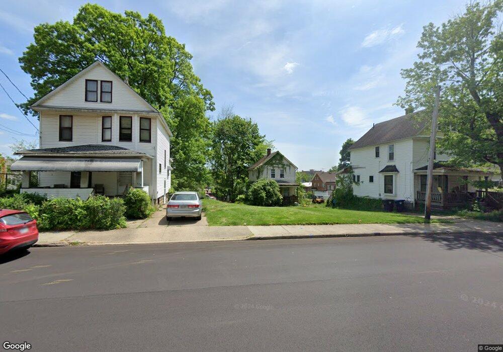
381 Rhodes Ave Akron, OH 44307
Sherbondy Hill NeighborhoodEstimated Value: $43,000
3
Beds
1
Bath
864
Sq Ft
$50/Sq Ft
Est. Value
About This Home
This home is located at 381 Rhodes Ave, Akron, OH 44307 and is currently priced at $43,000, approximately $49 per square foot. 381 Rhodes Ave is a home located in Summit County with nearby schools including Towpath Trail High School, St. Vincent Elementary School, and St Vincent-St Mary High School.
Ownership History
Date
Name
Owned For
Owner Type
Purchase Details
Closed on
May 31, 2017
Sold by
Wallacc Shirley and Scalise Kristen M
Bought by
The City Okron
Current Estimated Value
Purchase Details
Closed on
Jan 17, 2000
Sold by
Wallace Nettie B
Bought by
Wallace Nettie B and Wallace Shirley
Home Financials for this Owner
Home Financials are based on the most recent Mortgage that was taken out on this home.
Original Mortgage
$48,000
Interest Rate
7.81%
Create a Home Valuation Report for This Property
The Home Valuation Report is an in-depth analysis detailing your home's value as well as a comparison with similar homes in the area
Home Values in the Area
Average Home Value in this Area
Purchase History
| Date | Buyer | Sale Price | Title Company |
|---|---|---|---|
| The City Okron | -- | None Available | |
| Wallace Nettie B | -- | Trident Title Agency |
Source: Public Records
Mortgage History
| Date | Status | Borrower | Loan Amount |
|---|---|---|---|
| Previous Owner | Wallace Nettie B | $48,000 |
Source: Public Records
Tax History Compared to Growth
Tax History
| Year | Tax Paid | Tax Assessment Tax Assessment Total Assessment is a certain percentage of the fair market value that is determined by local assessors to be the total taxable value of land and additions on the property. | Land | Improvement |
|---|---|---|---|---|
| 2025 | -- | $9,867 | $3,434 | $6,433 |
| 2024 | -- | $9,867 | $3,434 | $6,433 |
| 2023 | -- | $9,867 | $3,434 | $6,433 |
| 2022 | -- | $5,804 | $2,020 | $3,784 |
| 2021 | $805 | $5,804 | $2,020 | $3,784 |
| 2020 | $0 | $5,800 | $2,020 | $3,780 |
| 2019 | $1,609 | $7,750 | $3,100 | $4,650 |
| 2018 | $0 | $7,750 | $3,100 | $4,650 |
| 2017 | $1,609 | $7,750 | $3,100 | $4,650 |
| 2016 | $1,609 | $7,860 | $3,100 | $4,760 |
| 2015 | $1,609 | $7,860 | $3,100 | $4,760 |
| 2014 | $844 | $7,860 | $3,100 | $4,760 |
| 2013 | $5,346 | $10,240 | $3,100 | $7,140 |
Source: Public Records
Map
Nearby Homes
- 478 Copley Rd
- 238 Gale St
- 243 S Balch St
- 483 Bishop St
- 222 Rhodes Ave
- 453 Briarwood Dr
- 413 Crestwood Ave
- 577 Rhodes Ave
- 524 Auld Farm Cir
- 568 Auld Farm Cir
- 136 Gale St
- 644 Diagonal Rd
- 434 Hillwood Dr
- 91 Westwood Ave
- 144 Hall St
- 414 Beechwood Dr
- 525 Crosby St
- 359 Beechwood Dr
- 867 Orrin St
- 262 S Portage Path
- 383 Rhodes Ave
- 387 Rhodes Ave Unit 389
- 377 Rhodes Ave
- 375 Rhodes Ave
- 395 Rhodes Ave
- 401 Rhodes Ave
- 382 Rhodes Ave
- 394 Douglas St
- 382 Douglas St
- 390 Douglas St
- 403 Rhodes Ave
- 392 Rhodes Ave
- 372 Rhodes Ave
- 398 Douglas St
- 370 Rhodes Ave
- 407 Rhodes Ave
- 406 Douglas St
- 367 Edgewood Ave
- 410 Douglas St
- 413 Rhodes Ave