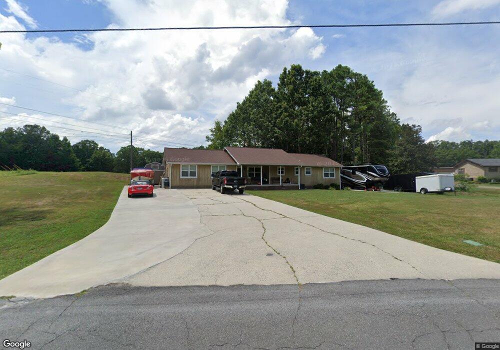
3811 Brock Rd SE Dalton, GA 30721
Estimated Value: $252,000 - $348,000
--
Bed
2
Baths
2,247
Sq Ft
$128/Sq Ft
Est. Value
About This Home
This home is located at 3811 Brock Rd SE, Dalton, GA 30721 and is currently estimated at $286,912, approximately $127 per square foot. 3811 Brock Rd SE is a home located in Whitfield County with nearby schools including Cedar Ridge Elementary School, Eastbrook Middle School, and Southeast Whitfield County High School.
Ownership History
Date
Name
Owned For
Owner Type
Purchase Details
Closed on
May 14, 2024
Sold by
Doran Connie Ruth and Doran Anthony
Bought by
Doran Connie Ruth and Doran Anthony
Current Estimated Value
Purchase Details
Closed on
Jun 1, 1997
Bought by
Doran Connie Ruth and Doran Anthony
Create a Home Valuation Report for This Property
The Home Valuation Report is an in-depth analysis detailing your home's value as well as a comparison with similar homes in the area
Home Values in the Area
Average Home Value in this Area
Purchase History
| Date | Buyer | Sale Price | Title Company |
|---|---|---|---|
| Doran Connie Ruth | -- | None Listed On Document | |
| Doran Connie Ruth | -- | -- |
Source: Public Records
Tax History Compared to Growth
Tax History
| Year | Tax Paid | Tax Assessment Tax Assessment Total Assessment is a certain percentage of the fair market value that is determined by local assessors to be the total taxable value of land and additions on the property. | Land | Improvement |
|---|---|---|---|---|
| 2024 | $2,369 | $93,910 | $5,216 | $88,694 |
| 2023 | $1,691 | $65,875 | $3,354 | $62,521 |
| 2022 | $1,351 | $54,359 | $3,292 | $51,067 |
| 2021 | $1,351 | $54,359 | $3,292 | $51,067 |
| 2020 | $1,386 | $54,359 | $3,292 | $51,067 |
| 2019 | $1,403 | $54,359 | $3,292 | $51,067 |
| 2018 | $1,400 | $53,716 | $2,649 | $51,067 |
| 2017 | $1,400 | $53,716 | $2,649 | $51,067 |
| 2016 | $1,220 | $49,095 | $2,649 | $46,446 |
| 2014 | $1,158 | $50,416 | $3,970 | $46,446 |
| 2013 | -- | $50,415 | $3,969 | $46,446 |
Source: Public Records
Map
Nearby Homes
- 3657 Airport Rd
- 01 Headrick Cir SE
- 00 Headrick Cir SE
- 1142 Ben Hill Rd SE
- 760 Keith Rd SE
- 4322 Banks Dr SE
- 185 Cedar Ridge Rd
- 2200 Ridge Rd SE
- 0 Tibbs Bridge Rd SE
- 296 Wagner Dr
- 1271 Ridge Rd SE
- 4386 Tibbs Bridge Rd SE
- 00 Tibbs Bridge Rd
- 00 Hill Rd
- TBD Old Grade Rd
- 0 Old Grade Rd
- 1401 Eastbrook Dr SE
- 741 North Dr SE
- 279 Satterfield Rd SE
- 118 Hill Rd
- 3815 Brock Rd SE
- 3812 Brock Rd SE
- 3817 Brock Rd SE
- 280 Gary Dr
- 202 Gary Dr
- 190 Gary Dr
- 3816 Brock Rd SE
- 00 Gary Dr
- 1175 Redbird Ln
- 3795 Brock Rd SE
- 3821 Brock Rd SE
- 368 Gary Dr
- 227 Gary Dr
- 3807 Airport Rd SE
- 327 Gary Dr
- 138 Crabapple Ln
- 343 Gary Dr
- 3823 Airport Rd SE
- 3825 Airport Rd SE
- 1027 Mobley Mill Rd SE