Estimated Value: $492,000 - $590,000
3
Beds
2
Baths
2,049
Sq Ft
$258/Sq Ft
Est. Value
About This Home
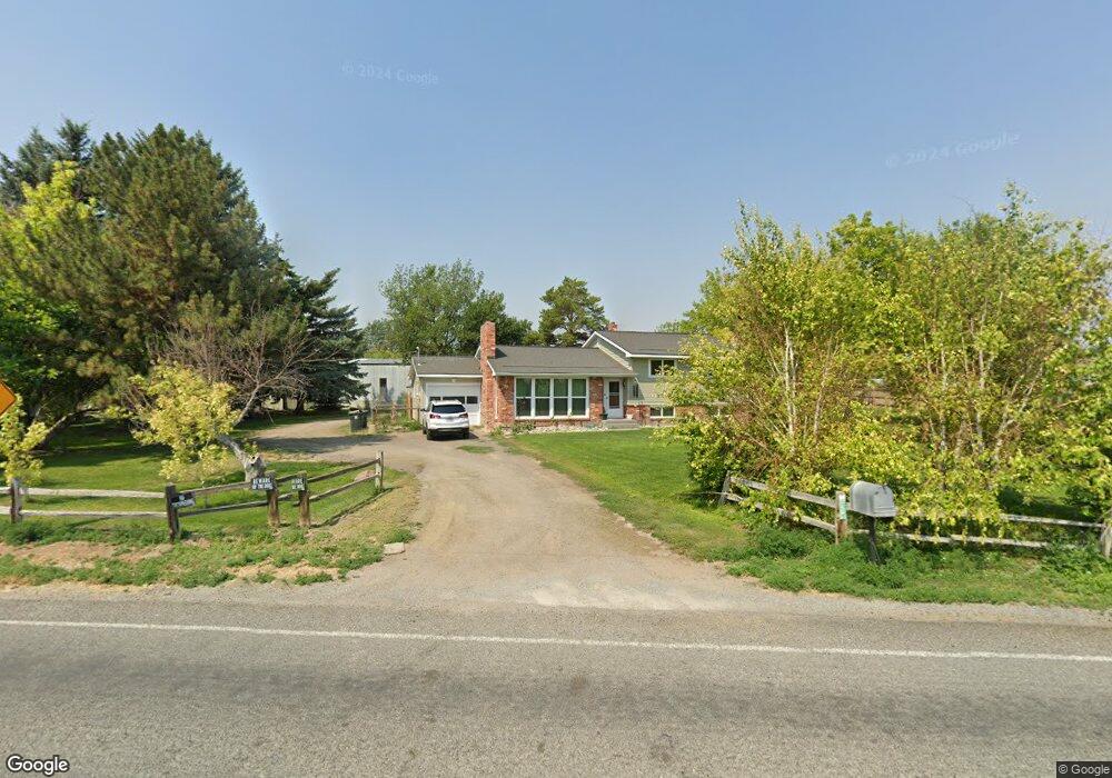
This home is located at 3811 N 2500 E, Filer, ID 83328 and is currently estimated at $527,790, approximately $257 per square foot. 3811 N 2500 E is a home located in Twin Falls County with nearby schools including Filer Elementary School, Filer Intermediate School, and Filer Middle School.
Ownership History
Date
Name
Owned For
Owner Type
Purchase Details
Closed on
Aug 17, 2011
Sold by
First Federal Savings Bank
Bought by
Shepherd George C
Current Estimated Value
Home Financials for this Owner
Home Financials are based on the most recent Mortgage that was taken out on this home.
Original Mortgage
$157,512
Outstanding Balance
$108,856
Interest Rate
4.53%
Mortgage Type
New Conventional
Estimated Equity
$418,934
Purchase Details
Closed on
Jun 21, 2007
Sold by
Volk Travis
Bought by
Rowe Violet Rae
Home Financials for this Owner
Home Financials are based on the most recent Mortgage that was taken out on this home.
Original Mortgage
$140,000
Interest Rate
6.41%
Mortgage Type
Purchase Money Mortgage
Create a Home Valuation Report for This Property
The Home Valuation Report is an in-depth analysis detailing your home's value as well as a comparison with similar homes in the area
Purchase History
| Date | Buyer | Sale Price | Title Company |
|---|---|---|---|
| Shepherd George C | -- | -- | |
| Rowe Violet Rae | -- | Twin Falls Title |
Source: Public Records
Mortgage History
| Date | Status | Borrower | Loan Amount |
|---|---|---|---|
| Open | Shepherd George C | $157,512 | |
| Previous Owner | Rowe Violet Rae | $140,000 |
Source: Public Records
Tax History
| Year | Tax Paid | Tax Assessment Tax Assessment Total Assessment is a certain percentage of the fair market value that is determined by local assessors to be the total taxable value of land and additions on the property. | Land | Improvement |
|---|---|---|---|---|
| 2025 | $1,345 | $413,266 | $145,706 | $267,560 |
| 2024 | $1,411 | $416,866 | $145,706 | $271,160 |
| 2023 | $1,474 | $417,256 | $145,706 | $271,550 |
| 2022 | $1,664 | $356,635 | $88,285 | $268,350 |
| 2021 | $1,332 | $264,950 | $55,870 | $209,080 |
| 2020 | $1,204 | $207,086 | $45,156 | $161,930 |
| 2019 | $1,162 | $193,496 | $45,156 | $148,340 |
| 2018 | $1,183 | $196,746 | $45,156 | $151,590 |
| 2017 | $1,103 | $181,676 | $45,156 | $136,520 |
| 2016 | $1,038 | $163,196 | $0 | $0 |
| 2015 | $1,023 | $163,196 | $45,156 | $118,040 |
| 2012 | -- | $145,455 | $0 | $0 |
Source: Public Records
Map
Nearby Homes
- 2468 E 3805 N
- 2531 E 3769 N
- 2531 E E 3769 N
- 2542 E 3753
- 2548 E 3753
- 2545 E 3753
- 2533 E 3759
- 2541 E 3759
- 3778 N 2555 E
- 2550 E 3759 N
- 0 Lot 9 Block 1 Unit 98932745
- Lot 8, Block 1
- 0 Lot 1 Block 1 Unit 98932739
- 0 Lot 4 Block 1 Unit 98932744
- 0 Lot 3 Block 1 Unit 98932742
- 2534 4000 N
- 176 3600 N
- 3940 N 2300 E
- 2342 Garey Ln
- 3983 N 2300 E
Your Personal Tour Guide
Ask me questions while you tour the home.