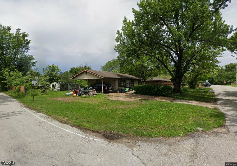
3811 Ronnie Ln Pacific, MO 63069
Estimated Value: $170,000 - $207,000
3
Beds
1
Bath
1,040
Sq Ft
$176/Sq Ft
Est. Value
About This Home
This home is located at 3811 Ronnie Ln, Pacific, MO 63069 and is currently estimated at $182,536, approximately $175 per square foot. 3811 Ronnie Ln is a home located in Franklin County with nearby schools including Pacific High School and St Bridget Elementary School.
Ownership History
Date
Name
Owned For
Owner Type
Purchase Details
Closed on
Sep 25, 2023
Sold by
Wilson Realty Inc
Bought by
Annie K Properties Llc
Current Estimated Value
Purchase Details
Closed on
Sep 1, 2017
Sold by
Franklin Financial Corp
Bought by
Wilson & Son Properties Inc
Purchase Details
Closed on
Mar 28, 2013
Sold by
Shaw William J
Bought by
Franklin Financial Corp
Purchase Details
Closed on
Apr 6, 2006
Sold by
Shaw William J and Shaw Debra S
Bought by
Franklin Financial Corp
Purchase Details
Closed on
Dec 29, 2005
Sold by
Anderson Sandy A
Bought by
Franklin Financial Corporation`
Create a Home Valuation Report for This Property
The Home Valuation Report is an in-depth analysis detailing your home's value as well as a comparison with similar homes in the area
Home Values in the Area
Average Home Value in this Area
Purchase History
| Date | Buyer | Sale Price | Title Company |
|---|---|---|---|
| Annie K Properties Llc | -- | None Listed On Document | |
| Wilson & Son Properties Inc | -- | -- | |
| Franklin Financial Corp | $84,328 | -- | |
| Franklin Financial Corp | -- | None Available | |
| Shaw William J | -- | None Available | |
| Franklin Financial Corporation` | -- | None Available |
Source: Public Records
Tax History
| Year | Tax Paid | Tax Assessment Tax Assessment Total Assessment is a certain percentage of the fair market value that is determined by local assessors to be the total taxable value of land and additions on the property. | Land | Improvement |
|---|---|---|---|---|
| 2025 | $1,630 | $21,835 | $0 | $0 |
| 2024 | $1,630 | $20,271 | $0 | $0 |
| 2023 | $1,516 | $20,271 | $0 | $0 |
| 2022 | $1,260 | $18,065 | $0 | $0 |
| 2021 | $1,255 | $18,065 | $0 | $0 |
| 2020 | $1,145 | $16,460 | $0 | $0 |
| 2019 | $1,144 | $16,460 | $0 | $0 |
| 2018 | $1,145 | $16,160 | $0 | $0 |
| 2017 | $1,137 | $16,160 | $0 | $0 |
| 2016 | $1,131 | $15,926 | $0 | $0 |
| 2015 | $1,101 | $15,926 | $0 | $0 |
| 2014 | $1,094 | $16,084 | $0 | $0 |
Source: Public Records
Map
Nearby Homes
- 3858 Ronnie Ln
- 3958 Highway Nn
- 1695 Wade Rd
- 403 Lakeview Dr
- 407 Lakeview Dr
- 0 Red Bud Unit MIS25053128
- 3 Oak Hill Rd
- 0 Oak Hill Rd
- Lot36 BLOCKF Redbud Dr
- Lot 44-48 Redbud Dr
- 3956 & 3960 Redbud Dr
- 3838 Oak Hill Dr
- 3830 Redwood Ln
- 3846 Oak Hill Rd
- Lot 45 Block G Red Bud Dr
- Lot 46 Block G Red Bud Dr
- 3939 Redbud Dr
- Lot 48 Block G Red Bud Dr
- 1414 Timber Valley Ct
- 2557 Nike Base Rd
- 3803 Ronnie Ln
- 3810 Ronnie Ln
- 3814 Ronnie Ln
- 3817 Ronnie Ln
- 3818 Ronnie Ln
- 2780 Tiny Ridge Way
- 293 Marjorie Ln
- 3889 Highway Nn
- 3822 1st St
- 3897 Highway Nn
- 3903 Highway Nn
- 3792 Twin Oaks Dr
- 3825 Ronnie Ln
- 3883 Highway Nn
- 3909 Highway Nn
- 3830 1st St
- 3830 1st St Unit SHOW!)
- 3826 Ronnie Ln
- 2794 Tiny Ridge Way
- 2761 Tiny Ridge Way
Your Personal Tour Guide
Ask me questions while you tour the home.