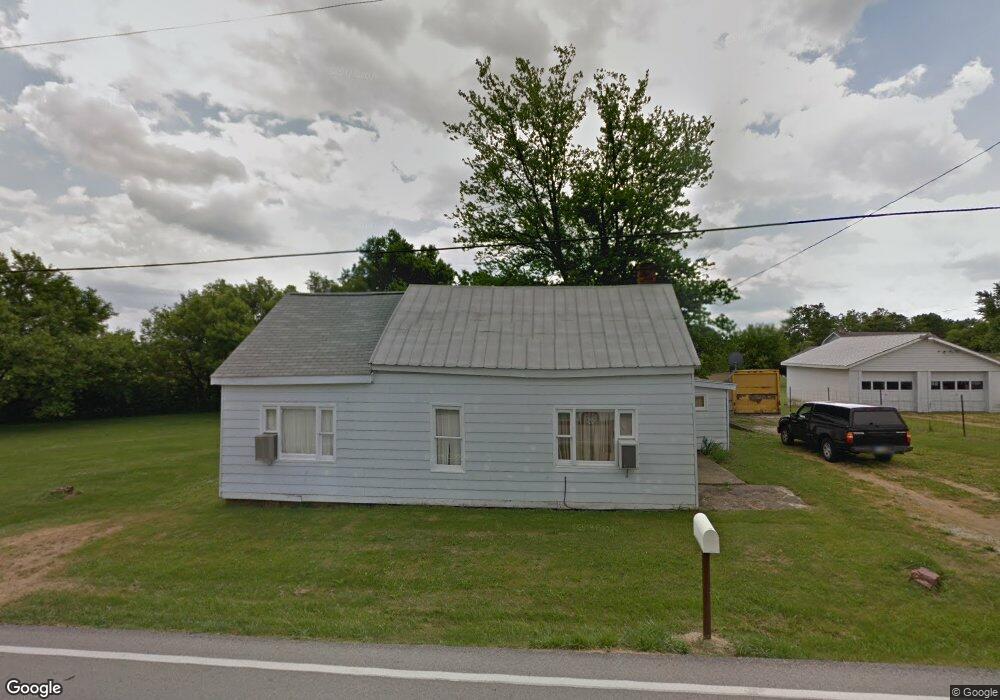
3816 State Route 350 Martinsville, OH 45146
Estimated Value: $78,520 - $173,000
2
Beds
1
Bath
1,176
Sq Ft
$109/Sq Ft
Est. Value
About This Home
This home is located at 3816 State Route 350, Martinsville, OH 45146 and is currently estimated at $128,380, approximately $109 per square foot. 3816 State Route 350 is a home located in Clinton County with nearby schools including East End Elementary School, Denver Place Elementary School, and Roy E. Holmes Elementary School.
Ownership History
Date
Name
Owned For
Owner Type
Purchase Details
Closed on
Nov 5, 2019
Sold by
Marshall Russell M
Bought by
Heal Sharon K and Heal Paul C
Current Estimated Value
Home Financials for this Owner
Home Financials are based on the most recent Mortgage that was taken out on this home.
Original Mortgage
$53,535
Interest Rate
3.74%
Mortgage Type
New Conventional
Purchase Details
Closed on
Jan 1, 1990
Bought by
Marshall Russell M
Create a Home Valuation Report for This Property
The Home Valuation Report is an in-depth analysis detailing your home's value as well as a comparison with similar homes in the area
Home Values in the Area
Average Home Value in this Area
Purchase History
| Date | Buyer | Sale Price | Title Company |
|---|---|---|---|
| Heal Sharon K | $53,000 | None Available | |
| Marshall Russell M | -- | -- |
Source: Public Records
Mortgage History
| Date | Status | Borrower | Loan Amount |
|---|---|---|---|
| Previous Owner | Heal Sharon K | $53,535 |
Source: Public Records
Tax History Compared to Growth
Tax History
| Year | Tax Paid | Tax Assessment Tax Assessment Total Assessment is a certain percentage of the fair market value that is determined by local assessors to be the total taxable value of land and additions on the property. | Land | Improvement |
|---|---|---|---|---|
| 2024 | $548 | $17,330 | $5,290 | $12,040 |
| 2023 | $548 | $17,330 | $5,290 | $12,040 |
| 2022 | $422 | $12,450 | $4,970 | $7,480 |
| 2021 | $427 | $11,750 | $4,270 | $7,480 |
| 2020 | $389 | $11,750 | $4,270 | $7,480 |
| 2019 | $304 | $9,270 | $2,720 | $6,550 |
| 2018 | $308 | $9,270 | $2,720 | $6,550 |
| 2017 | $298 | $9,270 | $2,720 | $6,550 |
| 2016 | $334 | $10,350 | $3,520 | $6,830 |
| 2015 | $342 | $10,350 | $3,520 | $6,830 |
| 2013 | $350 | $10,530 | $3,700 | $6,830 |
Source: Public Records
Map
Nearby Homes
- 162 Knolls Dr
- 3657 Farmers Rd
- 2457 Martinsville Rd
- 1200 Farmers Rd
- 67 Sweet St
- 89 E Main St
- 13 S High St
- 816 Farmers Rd
- 421 Silver Creek Dr
- 682 Leslie Dr
- 11ac Steele Rd
- ac Steele Rd
- 5891 Farmers Rd
- 0 Hildebrant Rd Unit 1856809
- 1529 Hildebrant Rd
- 85 Lakeview Place
- 50 & 62 E State Route 350
- 392 Romans Rd
- 62 Kings Ct
- 6086 S State Route 73
- 3816 St Rt 350
- 3675 State Route 350
- 3633 State Route 350
- 3798 State Route 350
- 3817 State Route 350
- 3799 State Route 350
- 3799 State Route 350
- 3780 State Route 350
- 6983 State Route 134
- 3799 St Rt 350
- 0 Greene Rd Unit 741749
- 0 Greene Rd Unit 692300
- 0 Greene Rd Unit 639312
- 0 Greene Rd Unit 1647476
- 0 Greene Rd Unit 1622737
- 0 Greene Rd Unit 1603716
- 38 St Rt 134
- 6868 St Rt 134 S
- 0 St Rt 350 Unit 1536886
- 0.162ac Ohio 350