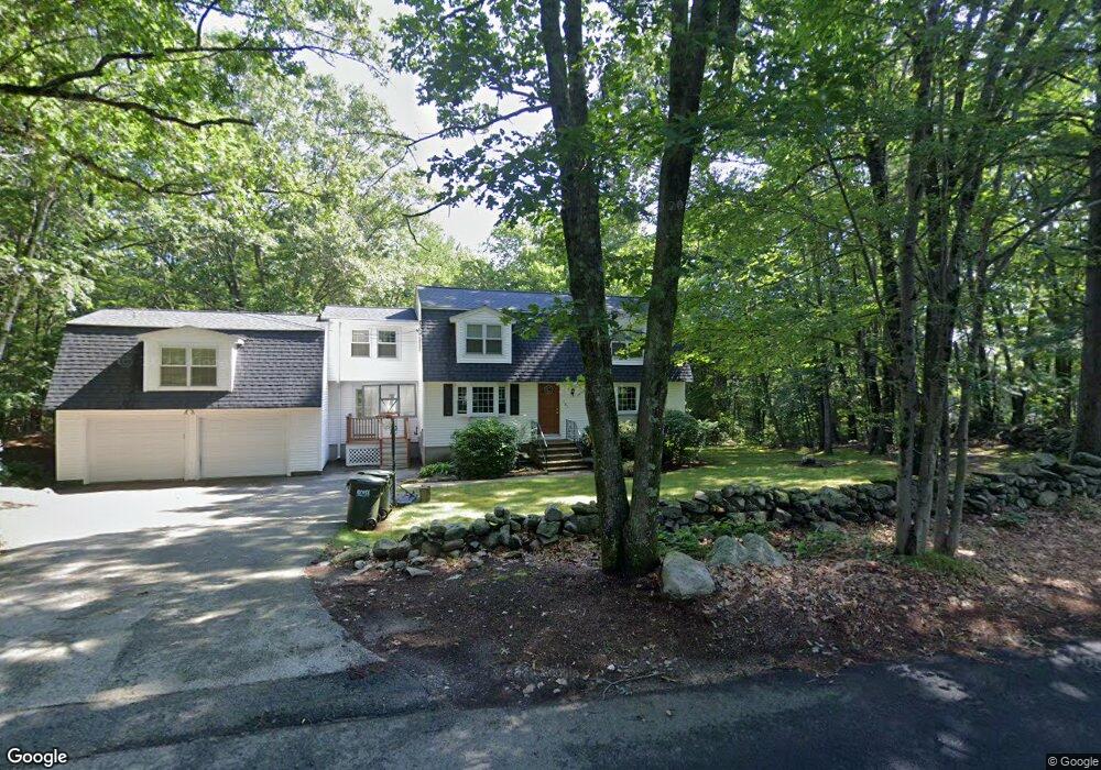
382 Pollard Rd Northbridge, MA 01534
Estimated Value: $675,469 - $804,000
4
Beds
4
Baths
2,660
Sq Ft
$279/Sq Ft
Est. Value
About This Home
This home is located at 382 Pollard Rd, Northbridge, MA 01534 and is currently estimated at $742,117, approximately $278 per square foot. 382 Pollard Rd is a home located in Worcester County with nearby schools including Northbridge Elementary School, Northbridge Middle School, and Northbridge High School.
Ownership History
Date
Name
Owned For
Owner Type
Purchase Details
Closed on
Feb 25, 1991
Sold by
Gallagher Stephen M and Gallagher Melissa M
Bought by
Ekberg Steven R and Ekberg Cynthia M
Current Estimated Value
Home Financials for this Owner
Home Financials are based on the most recent Mortgage that was taken out on this home.
Original Mortgage
$117,500
Interest Rate
9.53%
Mortgage Type
Purchase Money Mortgage
Create a Home Valuation Report for This Property
The Home Valuation Report is an in-depth analysis detailing your home's value as well as a comparison with similar homes in the area
Home Values in the Area
Average Home Value in this Area
Purchase History
| Date | Buyer | Sale Price | Title Company |
|---|---|---|---|
| Ekberg Steven R | $162,500 | -- | |
| Ekberg Steven R | $162,500 | -- |
Source: Public Records
Mortgage History
| Date | Status | Borrower | Loan Amount |
|---|---|---|---|
| Open | Ekberg Steven R | $208,000 | |
| Closed | Ekberg Steven R | $25,000 | |
| Closed | Ekberg Steven R | $113,000 | |
| Closed | Ekberg Steven R | $117,500 |
Source: Public Records
Tax History
| Year | Tax Paid | Tax Assessment Tax Assessment Total Assessment is a certain percentage of the fair market value that is determined by local assessors to be the total taxable value of land and additions on the property. | Land | Improvement |
|---|---|---|---|---|
| 2025 | $7,279 | $617,400 | $185,000 | $432,400 |
| 2024 | $7,053 | $583,400 | $185,000 | $398,400 |
| 2023 | $6,807 | $525,200 | $169,600 | $355,600 |
| 2022 | $6,377 | $463,100 | $130,500 | $332,600 |
| 2021 | $6,115 | $422,000 | $124,300 | $297,700 |
| 2020 | $518 | $408,600 | $124,300 | $284,300 |
| 2019 | $5,080 | $391,700 | $124,300 | $267,400 |
| 2018 | $3,080 | $375,600 | $118,300 | $257,300 |
| 2017 | $4,809 | $355,400 | $118,300 | $237,100 |
| 2016 | $4,653 | $338,400 | $107,500 | $230,900 |
| 2015 | $4,528 | $338,400 | $107,500 | $230,900 |
| 2014 | $4,487 | $338,400 | $107,500 | $230,900 |
Source: Public Records
Map
Nearby Homes
- 191 Hartness Rd
- 90 Leland Hill Rd
- 7 Central Turnpike
- 240 Roosevelt Dr
- 5 Wildflower Dr
- 220 Alana Dr
- 53 Fisherville Terrace
- 58 Fisherville Terrace
- 64 Fisherville Terrace
- 62 Fisherville Terrace
- 86 Mikes Way Unit 86
- 82 Central Turnpike
- 51 Lincoln Rd
- 24 Mcquades Ln
- 56 Luka Dr Unit 56
- 20 Wunschel Dr
- 175 Armsby Rd
- 578 Carpenter Rd
- 20 Millers Way Unit C
- 229 Worcester-Providence Turnpike
- 385 Pollard Rd
- 367 Pollard Rd
- 381 Pollard Rd
- 356 Pollard Rd
- 353 Pollard Rd
- 396 Pollard Rd
- 337 Pollard Rd
- 395 Pollard Rd
- 418 Pollard Rd
- 316 Pollard Rd
- 311 Pollard Rd
- 304 Pollard Rd
- 423 Pollard Rd
- 295 Pollard Rd
- 66R Maple Ave
- 290 Pollard Rd
- 210 Chipper Hill Rd
- 275 Pollard Rd
- 268 Pollard Rd
- 252 Pollard Rd
Your Personal Tour Guide
Ask me questions while you tour the home.