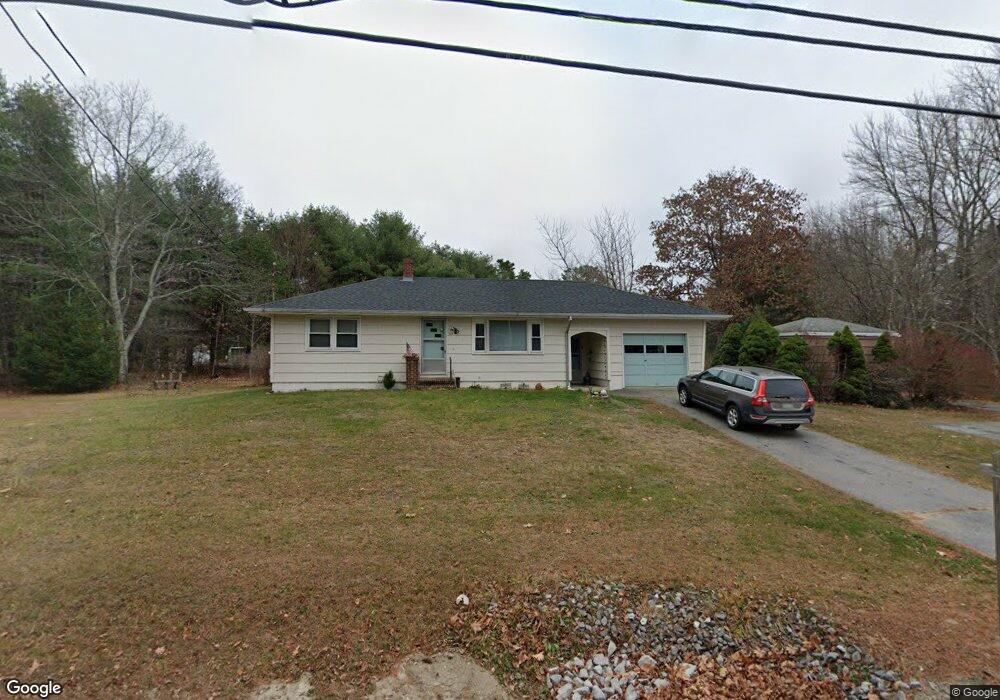
383 Mere Point Rd Brunswick, ME 04011
Estimated Value: $352,477 - $483,000
2
Beds
1
Bath
864
Sq Ft
$480/Sq Ft
Est. Value
About This Home
This home is located at 383 Mere Point Rd, Brunswick, ME 04011 and is currently estimated at $414,619, approximately $479 per square foot. 383 Mere Point Rd is a home located in Cumberland County with nearby schools including Kate Furbish Elementary School, Brunswick Jr High School, and Brunswick High School.
Ownership History
Date
Name
Owned For
Owner Type
Purchase Details
Closed on
Feb 4, 2014
Sold by
Thibeault Carmelle L
Bought by
Akladiss Therese
Current Estimated Value
Home Financials for this Owner
Home Financials are based on the most recent Mortgage that was taken out on this home.
Original Mortgage
$76,000
Interest Rate
4.47%
Mortgage Type
Unknown
Create a Home Valuation Report for This Property
The Home Valuation Report is an in-depth analysis detailing your home's value as well as a comparison with similar homes in the area
Home Values in the Area
Average Home Value in this Area
Purchase History
| Date | Buyer | Sale Price | Title Company |
|---|---|---|---|
| Akladiss Therese | -- | -- |
Source: Public Records
Mortgage History
| Date | Status | Borrower | Loan Amount |
|---|---|---|---|
| Closed | Akladiss Therese | $76,000 |
Source: Public Records
Tax History
| Year | Tax Paid | Tax Assessment Tax Assessment Total Assessment is a certain percentage of the fair market value that is determined by local assessors to be the total taxable value of land and additions on the property. | Land | Improvement |
|---|---|---|---|---|
| 2024 | $3,780 | $158,500 | $76,200 | $82,300 |
| 2023 | $3,691 | $158,500 | $76,200 | $82,300 |
| 2022 | $3,438 | $158,500 | $76,200 | $82,300 |
| 2021 | $3,306 | $158,500 | $76,200 | $82,300 |
| 2020 | $3,229 | $158,500 | $76,200 | $82,300 |
| 2019 | $3,126 | $158,500 | $76,200 | $82,300 |
| 2018 | $2,999 | $158,500 | $76,200 | $82,300 |
| 2017 | $3,615 | $196,800 | $99,000 | $97,800 |
| 2016 | $2,850 | $97,100 | $41,500 | $55,600 |
| 2015 | $2,754 | $97,100 | $41,500 | $55,600 |
| 2014 | $2,661 | $97,100 | $41,500 | $55,600 |
| 2013 | $2,577 | $97,100 | $41,500 | $55,600 |
Source: Public Records
Map
Nearby Homes
- 250 Mere Point Rd
- 6 Chebeague Ln
- 291 Maquoit Rd
- 6 Melden Dr
- 0 Melden Dr
- 51 Maquoit Rd
- 0 Gundalo Gap Rd Unit 1638108
- Lot 14 Village Cir
- Lot 15 Village Cir
- Lot 16 Village Cir
- Lot 8 Village Cir
- 32 Village Cir
- 23 Village Cir
- 20 Village Cir
- 9 Village Cir
- 4 Iris Way Unit 50
- 60 County Crossing
- 61 Woodside Rd
- 5 Round Hill Ln
- 307 Church Rd
- 19 Simpsons Point Rd
- 391 Mere Point Rd
- 30 Simpsons Point Rd
- 374 Mere Point Rd
- 386 Mere Point Rd
- 11 Simpsons Point Rd
- 370 Mere Point Rd
- 33 Simpsons Point Rd
- 397 Mere Point Rd
- 42 Simpsons Point Rd
- 384 Mere Point Rd
- Lot# 41 Simpson's Point
- 402 Mere Point Rd
- 403 Mere Point Rd
- 357 Mere Point Rd
- 14 Teaberry Ln
- 410 Mere Point Rd
- 411 Mere Point Rd
- 351 Mere Point Rd