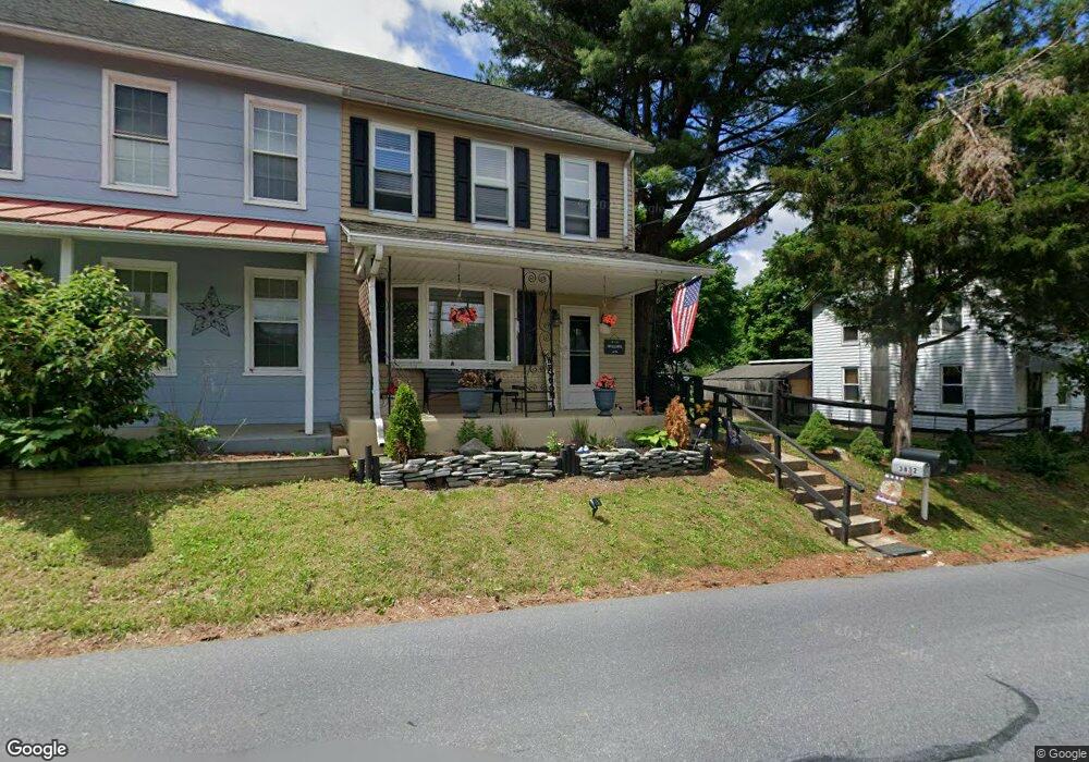
3832 Chestnut Rd Alburtis, PA 18011
Lower Macungie Township West NeighborhoodEstimated Value: $262,000 - $328,000
3
Beds
1
Bath
1,451
Sq Ft
$203/Sq Ft
Est. Value
About This Home
This home is located at 3832 Chestnut Rd, Alburtis, PA 18011 and is currently estimated at $293,973, approximately $202 per square foot. 3832 Chestnut Rd is a home located in Lehigh County with nearby schools including Alburtis Elementary School, Lower Macungie Middle School, and Emmaus High School.
Ownership History
Date
Name
Owned For
Owner Type
Purchase Details
Closed on
Nov 23, 1987
Sold by
Loux John N and Loux Mariam E
Bought by
Wisser Todd G and Scheirer Karen E
Current Estimated Value
Purchase Details
Closed on
Jun 12, 1984
Sold by
Goodman Richard M and Goodman Carol
Bought by
Loux John N and Loux Mariam E
Purchase Details
Closed on
Sep 29, 1983
Bought by
Goodman Richard M and Goodman Carol
Create a Home Valuation Report for This Property
The Home Valuation Report is an in-depth analysis detailing your home's value as well as a comparison with similar homes in the area
Home Values in the Area
Average Home Value in this Area
Purchase History
| Date | Buyer | Sale Price | Title Company |
|---|---|---|---|
| Wisser Todd G | $67,000 | -- | |
| Loux John N | $36,000 | -- | |
| Goodman Richard M | $30,000 | -- |
Source: Public Records
Tax History Compared to Growth
Tax History
| Year | Tax Paid | Tax Assessment Tax Assessment Total Assessment is a certain percentage of the fair market value that is determined by local assessors to be the total taxable value of land and additions on the property. | Land | Improvement |
|---|---|---|---|---|
| 2025 | $3,079 | $120,600 | $33,800 | $86,800 |
| 2024 | $2,979 | $120,600 | $33,800 | $86,800 |
| 2023 | $2,919 | $120,600 | $33,800 | $86,800 |
| 2022 | $2,850 | $120,600 | $86,800 | $33,800 |
| 2021 | $2,790 | $120,600 | $33,800 | $86,800 |
| 2020 | $2,763 | $120,600 | $33,800 | $86,800 |
| 2019 | $2,716 | $120,600 | $33,800 | $86,800 |
| 2018 | $2,680 | $120,600 | $33,800 | $86,800 |
| 2017 | $2,634 | $120,600 | $33,800 | $86,800 |
| 2016 | -- | $120,600 | $33,800 | $86,800 |
| 2015 | -- | $120,600 | $33,800 | $86,800 |
| 2014 | -- | $120,600 | $33,800 | $86,800 |
Source: Public Records
Map
Nearby Homes
- 428 Thomas St
- 317 Lockridge Ln
- 31 Barbara Dr
- 241 Flint Hill Rd
- 121 S Main St Unit 123
- 3371 Mathews Ln
- 354 W 2nd St
- 1108 S Barbara Dr
- 0 Clauss Hunt Knight Dr Unit 10 Units 763578
- 6903 Lincoln Dr
- 6709 Mountain Rd
- 0 Mountain Lot 1
- 4759 Sheep Rock Rd
- 7230 Pioneer Dr
- 6875 Pioneer Dr
- 7318 Sauerkraut Ln Unit E
- 6405 Robin Rd
- 167 Aspen Ln
- Lot 1 Mountain Rd
- 8312 Mertztown Rd
- 3842 Chestnut Rd
- 3820 Chestnut Rd
- 3814 Chestnut Rd
- 3854 Chestnut Rd
- 3806 Chestnut Rd
- 3866 Chestnut Rd
- 8210 Hensingersville Rd
- 3880 Chestnut Rd
- 8258 Hensingersville Rd
- 3845 Chestnut Rd
- 3867 Chestnut Rd
- 3839 Chestnut Rd
- 3901 Chestnut Rd
- 3875 Chestnut Rd
- 3819 Chestnut Rd
- 3805 Chestnut Rd
- 3797 Chestnut Rd
- 8313 Winchester Ln
- 8247 Hensingersville Rd
- 8298 Hensingersville Rd