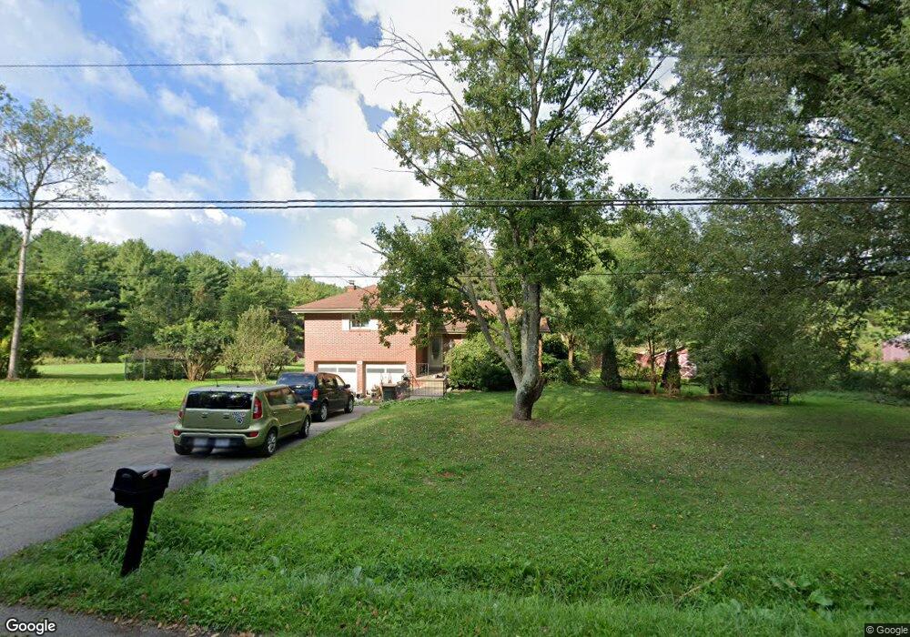
384 Collar Price Rd SE Brookfield, OH 44403
Estimated Value: $183,000 - $339,000
3
Beds
2
Baths
1,908
Sq Ft
$148/Sq Ft
Est. Value
About This Home
This home is located at 384 Collar Price Rd SE, Brookfield, OH 44403 and is currently estimated at $282,848, approximately $148 per square foot. 384 Collar Price Rd SE is a home located in Trumbull County with nearby schools including Brookfield Elementary School, Brookfield Middle School, and Brookfield High School.
Ownership History
Date
Name
Owned For
Owner Type
Purchase Details
Closed on
Apr 12, 2023
Sold by
Malutic Lisa
Bought by
Mcfall Paul and Li Hua
Current Estimated Value
Purchase Details
Closed on
May 30, 2017
Sold by
Fleck Peter and Samit Robert
Bought by
Davis Heather L
Home Financials for this Owner
Home Financials are based on the most recent Mortgage that was taken out on this home.
Original Mortgage
$167,000
Interest Rate
4.02%
Mortgage Type
New Conventional
Purchase Details
Closed on
May 20, 2011
Sold by
11955 Llc
Bought by
Stitt Heather L and Fleck Peter
Purchase Details
Closed on
Jun 28, 2006
Sold by
Stitt Michael R and Stitt Heather L
Bought by
11955 Llc
Purchase Details
Closed on
Jun 1, 2006
Sold by
Stitt Michael R and Stitt Heather L
Bought by
11955 Llc
Purchase Details
Closed on
Aug 8, 1994
Sold by
Boozer David M
Bought by
Anerino Brian and Anerino Tami
Create a Home Valuation Report for This Property
The Home Valuation Report is an in-depth analysis detailing your home's value as well as a comparison with similar homes in the area
Home Values in the Area
Average Home Value in this Area
Purchase History
| Date | Buyer | Sale Price | Title Company |
|---|---|---|---|
| Mcfall Paul | $240,000 | None Listed On Document | |
| Davis Heather L | -- | None Available | |
| Stitt Heather L | -- | Attorney | |
| 11955 Llc | -- | None Available | |
| 11955 Llc | -- | None Available | |
| Anerino Brian | $45,000 | -- |
Source: Public Records
Mortgage History
| Date | Status | Borrower | Loan Amount |
|---|---|---|---|
| Previous Owner | Davis Heather L | $167,000 |
Source: Public Records
Tax History Compared to Growth
Tax History
| Year | Tax Paid | Tax Assessment Tax Assessment Total Assessment is a certain percentage of the fair market value that is determined by local assessors to be the total taxable value of land and additions on the property. | Land | Improvement |
|---|---|---|---|---|
| 2024 | $3,352 | $71,440 | $16,280 | $55,160 |
| 2023 | $3,352 | $71,440 | $16,280 | $55,160 |
| 2022 | $3,626 | $62,650 | $17,570 | $45,080 |
| 2021 | $1,050 | $19,330 | $13,760 | $5,570 |
| 2020 | $1,043 | $19,330 | $13,760 | $5,570 |
| 2019 | $1,025 | $17,710 | $12,740 | $4,970 |
| 2018 | $1,016 | $17,710 | $12,740 | $4,970 |
| 2017 | $1,015 | $17,710 | $12,740 | $4,970 |
| 2016 | $1,123 | $18,840 | $14,180 | $4,660 |
| 2015 | $1,124 | $18,840 | $14,180 | $4,660 |
| 2014 | $1,119 | $18,840 | $14,180 | $4,660 |
| 2013 | $1,099 | $18,840 | $14,180 | $4,660 |
Source: Public Records
Map
Nearby Homes
- 6130 Warren Sharon Rd
- 209 Wyngate Dr
- 0 Albright McKay Rd NE
- 7086 Warren Sharon Rd
- 550 Warner Rd
- 7085 Sunnydell Dr
- 887 State Route 7 SE
- 1212 State Route 7 NE
- 6855 Stewart Sharon Rd
- 7290 Lee Rd NE
- 7182 Stewart Sharon Rd
- 5050 Warren Sharon Rd
- 5030 Pin Oak Dr
- 1472 Warner Rd
- 928 Bedford Rd
- 7440 Stewart Sharon Rd
- 1370 Custer Orangeville Rd
- 0 Smith Stewart Rd Unit 5120727
- 1555 Sodom Hutchings Rd NE
- 6976 White Oak Dr
- 345 Collar Price Rd SE
- 435 Collar Price Rd SE
- 332 Collar Price Rd SE
- 327 Collar Price Rd SE
- 6230 Warren Sharon Rd
- 6220 Warren Sharon Rd
- 6210 Warren Sharon Rd
- 6200 Warren Sharon Rd
- 468 Collar Price Rd SE
- 6186 Warren Sharon Rd
- 462 Collar Price Rd SE
- 6273 Warren Sharon Rd
- 6178 Warren Sharon Rd
- 6205 Warren Sharon Rd
- 6287 Warren Sharon Rd
- 6344 Warren Sharon Rd
- 490 Collar Price Rd SE
- 483 Collar Price Rd SE
- 483 Collar Price Rd SE
- 478 Collar Price Rd SE