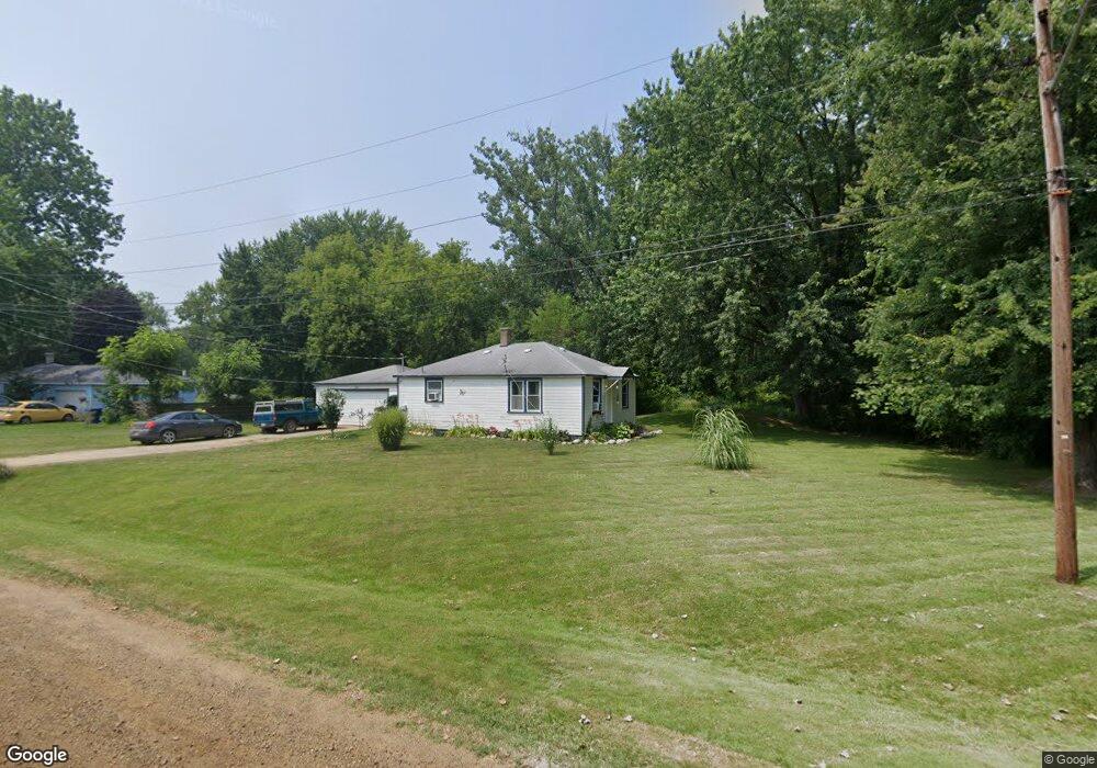
384 Vernon Rd Benton Harbor, MI 49022
Benton Heights NeighborhoodEstimated Value: $67,000 - $99,069
2
Beds
1
Bath
770
Sq Ft
$109/Sq Ft
Est. Value
About This Home
This home is located at 384 Vernon Rd, Benton Harbor, MI 49022 and is currently estimated at $83,767, approximately $108 per square foot. 384 Vernon Rd is a home located in Berrien County with nearby schools including Fair Plain Middle School, Benton Harbor High School, and Mildred C. Wells Preparatory Academy.
Ownership History
Date
Name
Owned For
Owner Type
Purchase Details
Closed on
Sep 10, 2018
Sold by
M & W Rental Properties Llc
Bought by
D & H Rentals Llc
Current Estimated Value
Purchase Details
Closed on
Jul 8, 2011
Sold by
Davies Justine and Davis Fred
Bought by
M & W Rental Properties Llc
Purchase Details
Closed on
Apr 30, 2010
Sold by
Davis Fred
Bought by
M & W Rental Properties Llc
Purchase Details
Closed on
Apr 27, 2010
Sold by
M & W Rental Properties Llc
Bought by
Davis Fred
Purchase Details
Closed on
Jan 26, 1989
Purchase Details
Closed on
Nov 4, 1988
Purchase Details
Closed on
Sep 16, 1988
Purchase Details
Closed on
Jan 13, 1986
Purchase Details
Closed on
Jun 1, 1972
Create a Home Valuation Report for This Property
The Home Valuation Report is an in-depth analysis detailing your home's value as well as a comparison with similar homes in the area
Home Values in the Area
Average Home Value in this Area
Purchase History
| Date | Buyer | Sale Price | Title Company |
|---|---|---|---|
| D & H Rentals Llc | $35,000 | First American Title | |
| M & W Rental Properties Llc | -- | None Available | |
| M & W Rental Properties Llc | -- | None Available | |
| Davis Fred | -- | None Available | |
| -- | $11,300 | -- | |
| -- | $100 | -- | |
| -- | $25,000 | -- | |
| -- | -- | -- | |
| -- | -- | -- |
Source: Public Records
Mortgage History
| Date | Status | Borrower | Loan Amount |
|---|---|---|---|
| Closed | D & H Rentals Llc | $0 |
Source: Public Records
Tax History Compared to Growth
Tax History
| Year | Tax Paid | Tax Assessment Tax Assessment Total Assessment is a certain percentage of the fair market value that is determined by local assessors to be the total taxable value of land and additions on the property. | Land | Improvement |
|---|---|---|---|---|
| 2025 | $1,313 | $31,500 | $0 | $0 |
| 2024 | $875 | $25,400 | $0 | $0 |
| 2023 | $833 | $23,900 | $0 | $0 |
| 2022 | $794 | $22,600 | $0 | $0 |
| 2021 | $1,123 | $21,900 | $3,000 | $18,900 |
| 2020 | $1,109 | $21,400 | $0 | $0 |
| 2019 | $1,089 | $16,500 | $1,800 | $14,700 |
| 2018 | $517 | $16,500 | $0 | $0 |
| 2017 | $510 | $15,300 | $0 | $0 |
| 2016 | $497 | $15,200 | $0 | $0 |
| 2015 | $496 | $15,300 | $0 | $0 |
| 2014 | $317 | $15,500 | $0 | $0 |
Source: Public Records
Map
Nearby Homes
- VL Clinton Rd
- 0 Vl Clinton Rd
- 2416 Highland Ave
- 2202 Berg Ave
- 425 N Euclid Ave
- 846 N Benton Center Rd
- 2431 E Britain Ave
- 000 N Euclid Ave
- 00 N Euclid Ave
- 0 N Euclid Ave Unit 24029856
- 1081 Villa Ct
- 948 Baldanza Ave
- 1187 Villa Ct
- 2277 Laurel Dr
- 640 O'Brien Dr
- 2062 Hatch Ave
- 2039 Taube Ave
- 1192 N Benton Center Rd
- 3547 N Blue Creek Rd
- 140 N Crystal Ave