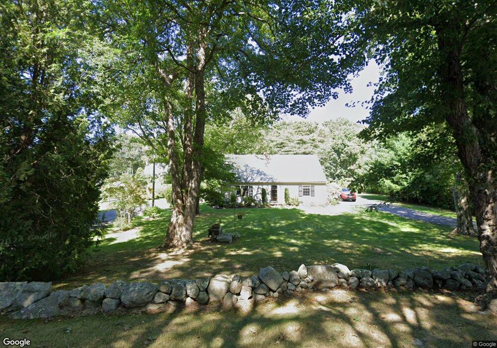
384 Weir Rd Yarmouth Port, MA 02675
Yarmouth Port NeighborhoodEstimated Value: $652,074 - $808,000
3
Beds
2
Baths
1,560
Sq Ft
$469/Sq Ft
Est. Value
About This Home
This home is located at 384 Weir Rd, Yarmouth Port, MA 02675 and is currently estimated at $732,019, approximately $469 per square foot. 384 Weir Rd is a home located in Barnstable County with nearby schools including Dennis-Yarmouth Regional High School and St. Pius X. School.
Ownership History
Date
Name
Owned For
Owner Type
Purchase Details
Closed on
Nov 30, 2011
Sold by
E&C Colbeth Ret and Colbeth Edward A
Bought by
Bruckhauser Karen and Woodward Martha
Current Estimated Value
Home Financials for this Owner
Home Financials are based on the most recent Mortgage that was taken out on this home.
Original Mortgage
$240,000
Outstanding Balance
$164,884
Interest Rate
4.1%
Mortgage Type
Purchase Money Mortgage
Estimated Equity
$567,135
Purchase Details
Closed on
Feb 4, 1998
Sold by
Mulrenin Robert R and Mulrenin Andrea M
Bought by
Colbeth Edward A and Colbeth Carol L
Create a Home Valuation Report for This Property
The Home Valuation Report is an in-depth analysis detailing your home's value as well as a comparison with similar homes in the area
Home Values in the Area
Average Home Value in this Area
Purchase History
| Date | Buyer | Sale Price | Title Company |
|---|---|---|---|
| Bruckhauser Karen | -- | -- | |
| Colbeth Edward A | $153,000 | -- |
Source: Public Records
Mortgage History
| Date | Status | Borrower | Loan Amount |
|---|---|---|---|
| Open | Bruckhauser Karen | $240,000 | |
| Previous Owner | Colbeth Edward A | $26,000 | |
| Previous Owner | Colbeth Edward A | $15,000 | |
| Previous Owner | Colbeth Edward A | $18,000 |
Source: Public Records
Tax History Compared to Growth
Tax History
| Year | Tax Paid | Tax Assessment Tax Assessment Total Assessment is a certain percentage of the fair market value that is determined by local assessors to be the total taxable value of land and additions on the property. | Land | Improvement |
|---|---|---|---|---|
| 2025 | $3,875 | $547,300 | $172,000 | $375,300 |
| 2024 | $3,601 | $488,000 | $149,600 | $338,400 |
| 2023 | $3,616 | $445,900 | $136,000 | $309,900 |
| 2022 | $3,376 | $367,800 | $129,800 | $238,000 |
| 2021 | $3,337 | $349,100 | $129,800 | $219,300 |
| 2020 | $3,323 | $332,300 | $137,400 | $194,900 |
| 2019 | $3,138 | $310,700 | $137,400 | $173,300 |
| 2018 | $2,961 | $287,800 | $114,500 | $173,300 |
| 2017 | $2,884 | $287,800 | $114,500 | $173,300 |
| 2016 | $2,771 | $277,700 | $105,400 | $172,300 |
| 2015 | -- | $260,500 | $100,800 | $159,700 |
Source: Public Records
Map
Nearby Homes
- 18 Crab Creek Ln
- 14 Many Oaks Cir
- 4 Old Colony Way
- 8 Rowley Ln
- 800 Route 6a
- 800 Route 6a
- 20 Trophy Ln
- 118 Driftwood Ln
- 6 Nimble Hill Dr
- 16 Warren Rd Unit 16
- 16 Warren Rd
- 129 Driftwood Ln
- 21 Boxwood Cir
- 15 Follins Pond Rd
- 13 Covey Dr
- 68 Seminole Dr
- 1 Winsome Rd
- 38 N Dennis Rd
- 4208 Heatherwood
- 28 Oak Glen