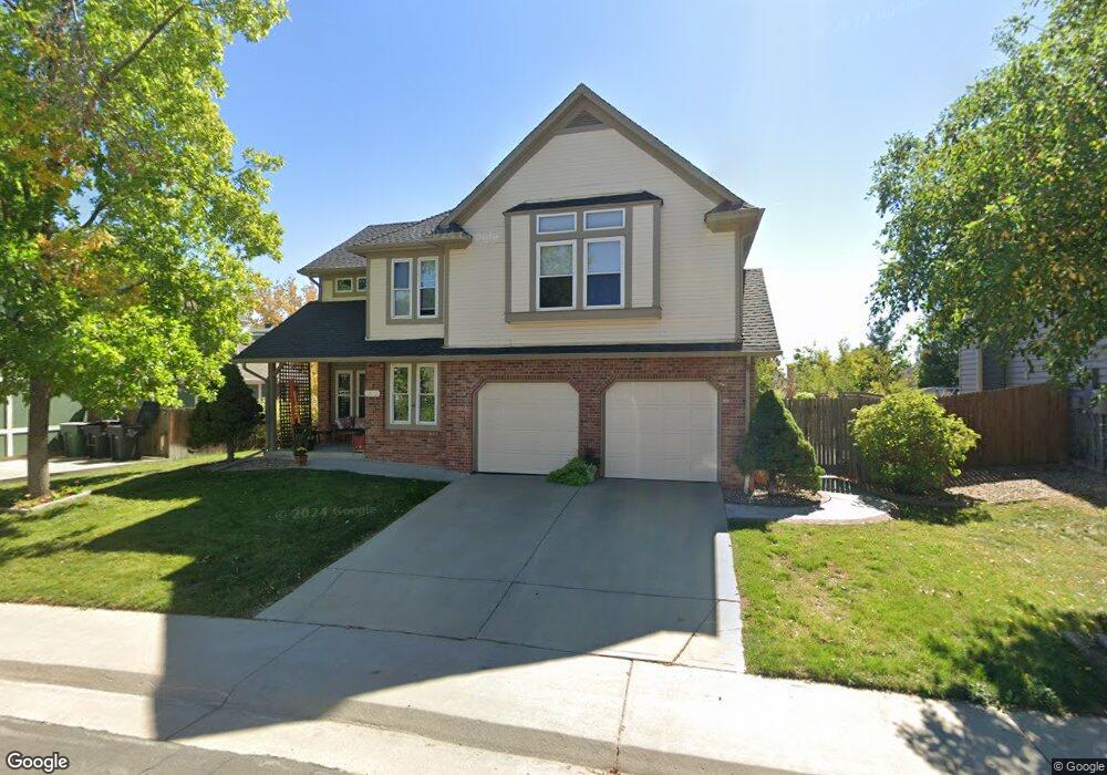
3840 E 135th Dr Thornton, CO 80241
Estimated Value: $503,000 - $599,000
3
Beds
3
Baths
2,206
Sq Ft
$248/Sq Ft
Est. Value
About This Home
This home is located at 3840 E 135th Dr, Thornton, CO 80241 and is currently estimated at $547,428, approximately $248 per square foot. 3840 E 135th Dr is a home located in Adams County with nearby schools including Tarver Elementary School, Century Middle School, and Horizon High School.
Ownership History
Date
Name
Owned For
Owner Type
Purchase Details
Closed on
Jul 21, 2009
Sold by
Krauser Carol A
Bought by
The Carol A Krauser Trust
Current Estimated Value
Purchase Details
Closed on
Aug 5, 1993
Create a Home Valuation Report for This Property
The Home Valuation Report is an in-depth analysis detailing your home's value as well as a comparison with similar homes in the area
Purchase History
| Date | Buyer | Sale Price | Title Company |
|---|---|---|---|
| The Carol A Krauser Trust | -- | None Available | |
| -- | -- | -- |
Source: Public Records
Tax History
| Year | Tax Paid | Tax Assessment Tax Assessment Total Assessment is a certain percentage of the fair market value that is determined by local assessors to be the total taxable value of land and additions on the property. | Land | Improvement |
|---|---|---|---|---|
| 2025 | $3,025 | $37,470 | $7,140 | $30,330 |
| 2024 | $3,025 | $34,440 | $6,560 | $27,880 |
| 2023 | $2,994 | $39,720 | $6,770 | $32,950 |
| 2022 | $2,313 | $27,950 | $6,950 | $21,000 |
| 2021 | $2,390 | $27,950 | $6,950 | $21,000 |
| 2020 | $2,298 | $27,750 | $7,150 | $20,600 |
| 2019 | $2,303 | $27,750 | $7,150 | $20,600 |
| 2018 | $2,086 | $25,330 | $7,200 | $18,130 |
| 2017 | $1,897 | $25,330 | $7,200 | $18,130 |
| 2016 | $1,406 | $21,040 | $4,220 | $16,820 |
| 2015 | $1,404 | $13,080 | $2,620 | $10,460 |
| 2014 | -- | $11,530 | $2,170 | $9,360 |
Source: Public Records
Map
Nearby Homes
- 0 Colorado Blvd
- 13488 Monroe St
- 13604 Garfield St Unit E
- 3867 E 133rd Ct
- 13608 Garfield St Unit D
- 4087 E 133rd Cir
- 13638 Garfield St Unit C
- 2615 Signal Creek Dr
- 13212 Clermont Cir
- 13222 Clermont Cir
- 13068 Harrison Dr
- 13064 Harrison Dr
- 13743 Steele Ct
- 13055 Harrison Dr
- 13064 Garfield Dr
- 2973 E 133rd Ln
- 13406 Clayton St
- 13004 Harrison Dr
- 13845 Adams Cir
- 13904 Cook St
- 3880 E 135th Dr
- 3800 E 135th Dr
- 13465 Harrison Ct
- 3788 E 135th Dr
- 3801 E 135th Dr
- 13475 Harrison Ct
- 13455 Harrison Ct
- 3799 E 135th Dr
- 3881 E 135th Dr
- 13477 Jackson Dr
- 13487 Jackson Dr
- 13467 Jackson Dr
- 3779 E 135th Dr
- 3901 E 135th Dr
- 3772 E 135th Dr
- 13497 Jackson Dr
- 13457 Jackson Dr
- 13551 Jackson St
- 13553 Jackson St
- 13450 Harrison Ct
Your Personal Tour Guide
Ask me questions while you tour the home.