Estimated Value: $562,000 - $665,000
4
Beds
3
Baths
3,722
Sq Ft
$165/Sq Ft
Est. Value
About This Home
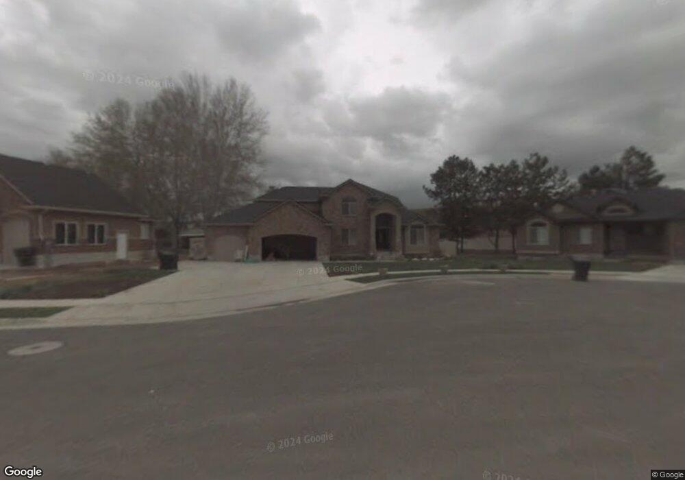
This home is located at 3841 S 950 W, Ogden, UT 84405 and is currently estimated at $614,329, approximately $165 per square foot. 3841 S 950 W is a home located in Weber County with nearby schools including Riverdale School, T.H. Bell Junior High School, and Bonneville High School.
Ownership History
Date
Name
Owned For
Owner Type
Purchase Details
Closed on
Jul 5, 2013
Sold by
Wade Scott J
Bought by
Wade Scott J and Wade Kathryn
Current Estimated Value
Home Financials for this Owner
Home Financials are based on the most recent Mortgage that was taken out on this home.
Original Mortgage
$262,200
Outstanding Balance
$189,606
Interest Rate
3.79%
Mortgage Type
New Conventional
Estimated Equity
$424,723
Purchase Details
Closed on
Apr 11, 2007
Sold by
Sanders Real Estate Llc
Bought by
Hanamaikai Quinn T and Hanamaikai Brittany
Home Financials for this Owner
Home Financials are based on the most recent Mortgage that was taken out on this home.
Original Mortgage
$57,000
Interest Rate
5.86%
Mortgage Type
Stand Alone Second
Create a Home Valuation Report for This Property
The Home Valuation Report is an in-depth analysis detailing your home's value as well as a comparison with similar homes in the area
Home Values in the Area
Average Home Value in this Area
Purchase History
| Date | Buyer | Sale Price | Title Company |
|---|---|---|---|
| Wade Scott J | -- | Hickman Land Title Company | |
| Wade Scott J | -- | Security Title Of Davis Coun | |
| Hanamaikai Quinn T | -- | None Available |
Source: Public Records
Mortgage History
| Date | Status | Borrower | Loan Amount |
|---|---|---|---|
| Open | Wade Scott J | $262,200 | |
| Previous Owner | Hanamaikai Quinn T | $57,000 | |
| Previous Owner | Hanamaikai Quinn T | $228,000 |
Source: Public Records
Tax History
| Year | Tax Paid | Tax Assessment Tax Assessment Total Assessment is a certain percentage of the fair market value that is determined by local assessors to be the total taxable value of land and additions on the property. | Land | Improvement |
|---|---|---|---|---|
| 2025 | $3,512 | $621,175 | $172,428 | $448,747 |
| 2024 | $3,349 | $333,299 | $94,835 | $238,464 |
| 2023 | $3,148 | $310,750 | $94,787 | $215,963 |
| 2022 | $3,393 | $341,550 | $94,787 | $246,763 |
| 2021 | $2,760 | $508,000 | $121,733 | $386,267 |
| 2020 | $2,437 | $414,000 | $72,814 | $341,186 |
| 2019 | $2,468 | $397,000 | $67,819 | $329,181 |
| 2018 | $2,451 | $377,000 | $67,819 | $309,181 |
| 2017 | $2,227 | $327,000 | $62,758 | $264,242 |
| 2016 | $1,961 | $156,608 | $28,028 | $128,580 |
| 2015 | $1,961 | $153,122 | $26,385 | $126,737 |
| 2014 | $1,984 | $153,122 | $26,385 | $126,737 |
Source: Public Records
Map
Nearby Homes
- 3757 S 900 W
- 4061 S 950 W
- 3940 Lamplighter Way Unit 40
- 644 W Lamplighter Way
- 621 Coachman Way
- 748 W 4075 S
- 658 W 4150 S
- 620 W 3600 S
- 1075 W 4175 S
- 592 W 3550 S
- 4256 S 1100 W
- 1198 W 4400 S Unit V
- 1198 W 4400 S Unit T
- 4418 S 850 W Unit 14
- 4375 Weber River Dr Unit 44
- 1114 W 4650 S
- 2985 Pennsylvania Ave
- 3800 S 1900 W Unit 256
- 3800 S 1900 W Unit 196
- 3800 S 1900 W Unit 63
Your Personal Tour Guide
Ask me questions while you tour the home.